Mishrikote fort was discovered while scanning Hubli area in Wikimapia. Mishrikote village is situated 18 kms South-West of Hubli. This is a Google Map screen-shot of the fort. It's almost a square in plan, few places are marked for reference.
A - Bastion
B - Fort entrance
C - Maruti Devasthana
D - Ramteerth Kere
E - Jain Mandir
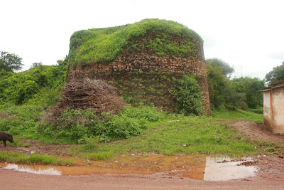
To be honest, Mishrikote looked like a village of ruins and in wet conditions the streets were a mess. The fort's is in complete ruins; most rampart walls have collapsed; only a part of the western wall stands. Mishrikote is surrounded by a moat however, the moat is a filled with trash and vegetation.
Ruins of the western wall and moat trench.
This is a village square outside the south-west corner of the fort.
Mishrikote fort entrance.
Within the fort walls are two ponds- Qilla Honda and Ramtheerth Kere. At the north-east corner of the fort is Ramtheerth pond.Within the fort are several temples, the ones I saw are Maruti Devastana and Uma Rameshwara Devasthana. Maruti temple is situated close to Ramtheerth Kere. Diety in Maruti temple looked ancient but the structure is new. Local folks mentioned a big Basavanna in Uma Rameshwara Devasthana but the temple doors were locked.
Outside the fort walls but within the village is a Jain temple- Bhagwan Shri 1008 Parshwanath Jaina Mandir.
Inside was a Digambhar monk; this was the first time I ever spoke to a Jain monk. He was camping here few days. With his permission I took pictures of the deity, a polished black granite statue.
Closer look at brass idols.
From Mishrikote I drove down to Kalghatgi to see the ancient Jain Mandir. Kalghatgi is also known for a family managed cottage industry manufacturing colorful cradles. However, I visited two Jain Mandirs and decided to head back home.
Mishrikote fort Coordinates: 15°14'47"N 75°3'39"E
.........


No comments:
Post a Comment