Jul 29, 2023

A tour of Vatapi Chalukyan realm - part3

July 18, 2022. After a good night sleep, we woke up early, fresh & energetic. We bathed, got ready and had a light breakfast near Durga temple complex junction. Our plan for the morning was to explore Aihole hill starting with the ancient quarry with an bathing place, then see the Jaina Basadi, the prehistoric megalithic tombs, Meguti Gudi, Boudha Chaitya and nameless temples on the hill. We drove straight to the Jaina Basadi which is on the western side of the hill and parked our car, got the cameras, a backpack with snacks & water and locked the car. This is my third or fourth visit to this spot, every single time this place has been peaceful. Behind me is the Basadi..

This Basadi is a special one because it's monolithic, like Ravalaphadi which is a kilometer from here. BTW, locals call this Myanada Basadi. Myanada means "made of wax" in Kannada. Ancient sculptors hacked this cone-shaped boulder, making it partially hollow inside. While we were here, a canine watched us from the boulder top...it was curious about tourists coming this early.
I wanted to spend a few minutes here so that Pushpa could see this shrine created in VII or VIII Century CE i.e. during the early Chalukyan times. This is the fifth rock-cut shrine in this trip, the earlier ones being the four rock-cut temples of Badami. Straight ahead in this picture is the western slope of Aihole hill. On the slope are natural shelters, a few suitable for humans and a number of smaller caverns which could be inhabited by wild animals. In a few shelters paintings dating back to the Neolithic times can be seen. The lower part of the slope is a former quarry, signs of quarrying activity can be seen even to this day. Do read my earlier post on Ravalaphadi & ancient sandstone quarry.
The temple has two sections; inner and outer. The outer section is a rectangular hall with Jaina motifs on the ceiling, and on the walls are relief sculptures of Parshvanatha and Bahubali. One portion of the ceiling art has a maze of Swastika & Kamala. The inner section is a larger hall with three sanctums i.e. Garbhagudi. Only the south-facing sanctum has a deity i.e. a life-size idol of Mahaveera. The sanctum is flanked by guards holding lotuses. All inner doorways feature pairs of sculpted pillars. A huge relief sculpture occupies the entire ceiling of the inner hall. The sculpture features five lotuses, four forming a square and the fifth at the point where the diagonals meet. It's a pretty complex piece of work showing floral motifs, a pair of human faces, and imaginary creatures. One could spend hours studying these amazing works of arts.
After spending about 15 minutes in the Basadi, we moved on to see the ancient quarry. I wanted to see the bathing spot and show it to Pushpa. Though I had seen it earlier I missed it as we passed by it. It was Pushpa who spotted it. Here we are, the showering place with a natural water source. The sculptors have made a groove to channelize the water and a small cavity at the edge of the vertical face. There's some engineering in the groove & cavity design to handle different rates of flow.
The vertical face seen here seems like a combination of natural and manmade. If you look closely, a outline of a pillar can be seen. Possibly the sculptors had planned some aesthetic touches. Just above the horizontal band are two inscriptions which seems to be two different names. These are two of the many other inscriptions here.
In the picture below, see the chisel marks along the curved edge. A good portion of this rock has been cut away systematically. Ancient stone workers were expert geologists, with the knowledge they possessed they cut & shaped stones as though they were wax. There are plenty of such quarried rocks on this side of the hill.
Close to the bathing place, we found this rock with series of vertical bars. These sets of bars as I understand is sculptor's work log, may be the master sculptor's log. Probably each bar denotes a week or a day. We had seen similar 'logs' and also names inscribed at Badami cave temples site.
We decide to move on. Next on our list was the prehistoric megalithic tombs site for which we had to get on the hill. The hill top is a 640m long sloping plateau, of I may call it that. During my previous visit here, we had counted 70+ tombs of various sizes, all of them made of slabs sourced locally. Meanwhile, the curious canine had become our friend and tagged along. Somewhere in the vicinity was another canine which was little shy, it followed us but at a distance.
This is one of the first tombs we see as we head in the northerly direction. Each of these tombs is a simple assembly of five slabs; four vertical slabs forming a four-walled chamber and a capstone. Most of these tombs have been vandalized by treasure hunters. That's the reason why most of these tombs seem like assemblies of three or four slabs. In this picture, the slabs lying on the ground must've been a demolished tomb. Since we are looking at tombs, one might wondering about the burial.
This is another badly damaged tomb, two of the walls have been removed which has exposed the innards which is a mass of red dirt. I'm trying to imagine the burial process. First the four walls are positioned to create a open chamber. Next a bed of soil is prepared, the corpse is placed on the bed and then covered with more soil until the chamber is completely packed. Then the much heavier capstone is placed thereby sealing the chamber making it scavenger proof. Neolithic period in India is starts 6500 BCE and ends 1400 BCE. These structures remained undisturbed for thousands of years but the present day humans simply can't leave things alone.
Of the 70+ tombs, this particular structure is probably the biggest and the best preserved. I'm not sure is each tomb was meant for one body or more. The larger the tomb, the more I wonder how the ancient people handled these heavy slabs. What kind of tools did they use to cut & shape them? So many questions..
This region, part of present day Bagalkot district, was very active during the Neolithic times. There were hundreds of such sites here and surrounding districts however many have been lost over time. Ancient humans here became expert at stone crafting. Their deep interest evolved the designs, technology, skills and talents. The products of that evolutionary process are rock-cut temples, structural temples and other ancillary structures like stepped wells, shelters and arches. Apart from structures stone workers also produced utility tools like ladders, water troughs, grinding stones, etc.
All the walking and climbing had worked up our appetite. We decided to take a break and snack. We had madkikaal sprouts (bean sprouts), banana chips and water. Our canine friends won't eat sprouts, we could only offer them chips.
The next item on the list was Meguti Gudi which was a stone's throw away. As we walked towards Meguti we scanned the area between this hill and Malaprabha where there are several temples, both individual and groups. Below is a snapshot of Google Maps of the area we focused on. I've marked the place where we stood (X) and the four temples with A, B, C & D. A is Boyar Gudi and the remaining are nameless temples, may be the villagers have names for them, need to check during the next visit.
Here's a collage of the four temples. While pictures A, C and D were shot in this trip, B was shot way back 2011. I had seen Boyar Gudi (A) and B in 2011. Here's a short blog post of Boyar Gudi & Huchappayyana Mata. There are close to 125 individual temples in Aihole. For the ancient temple builders Aihole was a laboratory where they experimented different designs. One can find permutations & combinations of various aspects of a temple like orientation of sanctum / entrance; number of sanctums / entrances; pillar designs; vestibule, halls & portico designs; and so on. With so much to see, one cannot really justify one visit to Aihole, it has to be several visits.

We reach the fort like wall around Meguti Gudi. Locals have made a small 'breach' in the wall which serves as a short cut. This is a view of the wall from the gap. This wall runs along the edge of the hill, to be clear this enclosure is situated at the northern end of the hill.

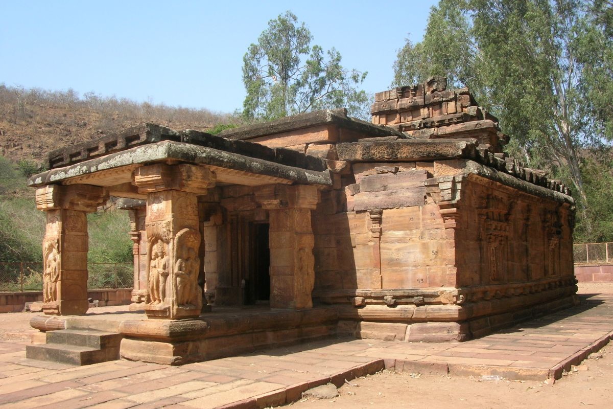
The north-facing Meguti Gudi, positioned almost at the center of the enclosure. Meguti is corrupted form of Megudi ~ Meline Gudi meaning upper temple. Most temple names here are derived from their location or the family / individual who had occupied it before ASI took charge. Going by archaeological findings, this is a Jain Basadi. On the left side wall of this temple is a Kannada inscription dated 634 CE. The inscription praises Chalukyan king Pulakeshi II for his support for this temple construction.

Meguti Basadi as seen through the gateway. Behind me is a long flight of steps which goes down to the base of the hill. About 20 to 25 steps down, is a Buddhist shrine.

This is the two-storey Boudha Chaitya dating back to the VI Century CE. This shrine is a combination of rock-cut & structural i.e. the façade is structural while the inner portion is rock-cut. The square section columns seem simple but they feature some clever designs. Directly opposite to this side of the hill are two temple groups- Mallikarjuna and Jyotirlinga and in a distance are Huchimalli Gudi and Ravalaphadi.

This image of a meditating Buddha is on the ceiling of the upper portico. 

On the northern slope are four smaller temples, of which one is a rock-cut temple. Sadly these temples have been neglected, the surroundings are filthy, and moreover in rainy season its better not to go there. One of the objectives of this visit was to closely see the rock-cut temple but I had to drop it. Here's a collage of the hill slope, two temples are visible and the rock-cut shrine in the inset. These pictures were shot from the road on the following morning as we said bye to Aihole. As I know Aihole has four rock-cut shrines, there could one or two more in any of the groups.

This building in the foreground is a Desai Vaadae. I think during one of the earlier visits with two of my uncles, we had been inside that complex. Besides the Vaadae is Tryambakeshwara group and across the road is Charantimath complex. A decade ago I'd heard about a plan to relocate all residents and make Aihole a exclusive tourist center. However due to technical hurdles the plan is on the backburner. I try to imagine a decluttered Aihole, like how it was between VI and XII Centuries.

Having covered Aihole hill we head back the way we came. Our canine friends were still with us but sadly we did not have anything to treat them with.

This is the southern end of the hill, Pushpa is seen coming out from the gap between the rocks. This spot is almost behind the rock-cut Jaina Basadi we saw in the beginning of this post. I think this is the 'official' ancient entrance to the megalithic site. In fact the ground has stones which are more or less like steps, very convenient - I feel those stepping stone arrangement is manmade.

We were kind of tired because of the humid weather, when its cloudy it feels stuffy and uncomfortable. After a 5-minute rest we loaded our stuff into the car. Just before getting into the car I happened to notice a triangle shaped stone, I picked up out of curiosity and realized it was a stone axe. Wow! I just found an implement made by a prehistoric man. Most likely a man's work, because women were engaged with children and gathering food. This collage shows both sides of the axe head. Its around 10 cm long, 5.5 cm wide and 3 cm thick, very nicely shaped, surely an expert has made it. In the left hand side image, see the top edge which had been sharpened. I think this axe was well used. This finding made my morning!

The next item on our list was Ramlingeshwara group of temples and Galaganatha temple complex, both situated on Malaprabha right bank. This article will continue in the following post... A tour of Vatapi Chalukyan realm - part4.
.........

Jul 22, 2023

A tour of Vatapi Chalukyan realm - part2

Now we almost at the hill top. At the end of the passage is the sixth gateway Badami northern fort. This passage seems like a natural one; or may be it's a natural passage modified to make it man friendly.

The passage has a T-junction; the left side is blocked by trees and few boulders and the right side is paved and fit for easy walking. The passage gradually fades away as we reach the hill top which is a rough surface. At the elevated are these two domes. Each of the domes have a rectangular doorway close to their bases. These are said to be ancient granaries.
Right besides the granaries is a ruined structure which looks like shelters for guards on duty here. In the foreground is a wall with gaps to shoot arrows; in the middle ground is the rock formation with the passage through which we reached here; and in the background is a huge turret and a natural mound which is a good view point.
As you see it was a partly cloudy sky. These low level clouds trap heat. Weather was warm and humid. Heat radiating from these rocks made it even more uncomfortable. It was a relief when it got breezy. A few minutes back, close to Lower Shivalaya, we happened to befriend a tourist from Kalburgi side, he tagged along with us. I guess our friend Praveen was apprehensive of coming here alone. This place has a history of unpleasant incidents, Praveen's hesitation was justified. However when we reached the top we saw an armed guard near Upper Shivalaya. The day-time guard has been posted to discourage treasure hunters from vandalizing monuments on this hill. Also the presence of an armed guard is a consolation for tourists.
As per the Heritage Series booklet on Badami, Upper Shivalaya may be built in the middle of VI Century CE when Chalukyan kings were worshippers of Vishnu. It also mentions that the original deity of this temple was Vishnu, however the sanctum now has only a pedestal but no deity. The temple has several windows with creative grill work. The external walls have relief sculptures depicting depicting scenes from Sri Krishna Charitha, Govardhana Giridhari, Kaliyamardini Krishna, Ugranarasimha and Ganas.
Being situated at a corner and edge of the cliff, this spot has a great view of Agastya Honda, the north fort & cave temples and Badami town. When one stands at this spot, one is bound to wonder how the builders worked. I wonder if safety nets fixed or scaffolding erected to prevent accidents.
Talking about cliffs, here we have a chasm which is 50' to 60' deep. At the bottom-left corner of the picture, the gap is narrow, may be 10' to 12' wide. This is a monkey crossing spot, only the fittest & bravest of monkeys leap across the gap. Other monkeys have to climb all the way down and climb up to the other side. 
After spending about 30 minutes at Upper Shivalaya we head back. We squeeze through the narrow gap to reach the kings' meeting place. As you see, here we have two pillared shelters. These shelters are actually quite big, in fact they are so high that climbing on to them is not an easy task. However, centuries ago, there would've been arrangements like ladders or portable steps for the royal members convenience. This spot has sheer drops on all sides and only one way to access hence this is an ideal place for secret meetings.
The return journey through the passage was tougher. It left me warm & sweaty, it was a relief to come out of the passage. From here we went to the museum. The museum has clean restrooms & washbasins, I washed my arms and face, it felt so refreshing. We spent about 15 minutes seeing the exhibits most of which are stone sculptures found in Badami and surrounding places. The Lajja Gowri sculpture here is the most treasured item. Besides sculptures, there are prehistoric artifacts. Then there's a scale model of Sidlapadi, the naturally formed sandstone arch. Sidplaphadi is a prehistoric site situated on the sandstone hill of Badami. After the tour of the museum we rested here a while and headed back to the car parking area. Meanwhile I had invited our friend Praveen to join us to see Shivayogi Mandir, Mahakoota and Pattadakal.
As we drove towards Banashankari I remembered my visits to Ranganatha Swamy Gudi and the rock paintings site. Ranganatha Swamy Gudi is situated in a cleft. One has to climb up a few hundred steps to reach the temple. The prehistoric paintings site is visited only by people who a really interested in prehistory. To reach it one has to walk about a kilometer, part of which is a steep climb through clusters of thorny shrubs. I'm thankful to Dr. Umesh who had introduced his friend here who helped me reach this rare site. The site is rare because of the nature of  the paintings.. they depict creatures- humanoid and animals -which seem alien. One of the paintings shows a rocket and an astronaut.
We skip going to Banashanakari temple since it is always crowded. This picture of the lamp tower was shot years ago. During one of the visits, I had climbed it, an experience I won't forget.
From Banashankari, we head towards Shivayogi Mandir. On the way, one could stop at Naganatha Kolla which is about a kilometer away from the main road. This handsome looking temple is called Naganatha Gudi, one of the many Chalukyan creations of this region. The sculptures of amorous couples on the portico pillars are quite interesting. This spot, where two hills merge or two arms of a hill merge is called a Kolla. Usually a Kolla has a source of flowing water. Since this Naganatha Gudi is situated here this place is called Naganatha Kolla.
We didn't stop at Naganatha Kolla during this trip, we moved on towards Shivayogi Mandira which is situated on the left bank of river Malaprabha. Established in the year 1909 to protect local breed cow, presently Shivayogi Mandir is known for the following: 1. a school to train Matadipathis (Lingayath and Veerashaiva monastery heads), 2. a library of religious scripts including Talegari Shasana (scriptures written on palm leaves), 3. Ayurvedic hospital, and 4. Vibhuti making center. The basic ingredient of Vibhuti is dung of local breed cow. Shivayogi Mandira's annual fair is attended by thousands of people and, it conducts daily Anna Dasoha.
We visited the Samadhis of the founding Swamijis and then proceeded to partake Prasada at monastery's dining hall. After Prasada we purchased a Vibhuti block. We were the last customer for the day. Shivayogi Mandira's Vibhuti has great demand but production is limited, each person/group can buy only one Vibhuti per day. Lastly we saw the Vibhuti making center where most workers are women. It's a simple setup producing the highly revered Vibhuti.
By 1-30 PM or so we left Shivayogi Mandira and headed towards Mahakoota, a group of temples, built during Chalukyan times. For some reason the Chalukyans created two Mahakuta known as Halae Mahakoota (old) and Hosa Mahakoota (new). These places are a few kilometers away, both are situated at the eastern base of Badami hill, a few kilometers between them. Both Mahakoota have natural source of fresh water. Halae Mahakoota has a temple which is apsidal in plan and a group of 4 or 5 smaller shrines. I'd been here in Sept 2012 and the next visit was this day. However, this visit was little disappointing because the historical site was under renovation, it looked like a construction site. So we did not bother getting out of the car, we moved on towards Hosa Mahakoota or simply Mahakoota.
Mahakoota is a very popular place, it attracts huge crowds on holidays, on Amavasya and Hunnime days and festivals like MahaShivaRatri. Unlike Halae Mahakoota, here the freshwater pond & group of temples are enclosed in a quadrangle.
All these temples are of the same architecture, all are built of sandstone, so I guess all were built during the period of Chalukyas. Besides these ancient temples, this site also has a number of ancient trees, they too have the age old look. The presence of trees gives this place a special feel, like we are in another world. This is how I felt during my first visit here in 2010... click on this link to see Mahakuta in 2010.
However, this visit was a disappointment because of the noisy crowd. This spring water pond is the main reason for the crowd. Pushpa and our friend Praveen too were kind of taken back at the lack of sensitivity of the boys who were yelling and diving into water. I observed the crowd several minutes, could hear plenty of Urdu phrases. This noisy bunch wasn't here to visit temples, this was a free resort for them. I was angry, upset... there were so many other people who came as pilgrims, to perform rituals, none of them objected to the outsiders' behavior. Even the temple staff hadn't bothered to intervene. This reminded me of similar incidents at Nagavi and Gangibavi, same Urdu blabbering teenagers creating havoc at a holy place. These 'people' are abusing the accommodating nature of  Hindu people. Time to put up resistance and end such nonsense.
Anyway, I would to mention a underwater shrine dedicated to Shiva. One needs to dip into water and pass through a gap in the side wall of the pond to see the shrine. Hopefully I'll come here one early morning and see that shrine, and spend time in the peaceful ambiance.
During my first visit here, we had discovered a pair of strange looking sculptures flanking a gateway. So this structure here is the original gateway of Mahakoota. Flanking the passage is a pair of shriveled characters called Kaala and Kaali, very captivating sculptures. I make sure to see them during every visit. The other thing I would like to say here is a footpath connecting Mahakoota and Badami. The path traverses over the hill, approximately 8 km trek. I really want to do this trek once.
Having spent thirty minutes at Mahakoota, we left the place and headed to Pattadakal. In the meantime, clouds had gathered and air felt humid. Pattadakal, unlike Badami or Aihole, is a closed group of temples in one enclosure, all dedicated to Shiva. In this enclosure there are approximately 17 temples however only 8 of them have names and the remaining are minor structures. Then there are two temples in walking distance outside of the enclosure, at two sites away from each other. The interesting part is that the temple enclosure is situated on the left bank of Malaprabha river, where Malaprabha bends and flows northward. Such a spot is considered holy in Hindu traditions and coronation ceremonies were conducted here. Hence this place is called Pattadakallu.
Most tourist guides at Pattadakllu start their tour by saying that Aihole was the cradle of temple architecture, so it was called as the school; and Pattadakallu was the college. Perhaps one must see Aihole & Pattadakallu a few times to get a hang of school & college idea. Of course, Chalukya builders didn't limit their creations to just the well known tourist spots, there are several less known sites whose history go back to Neolithic times.
The ten temples (eight plus two) are as follows: 1. Kaada Siddeshwara Gudi, 2. Jambulingeshwara Gudi, 3. Galaganatheshwara Gudi, 4. Chandrashekhara Gudi, 5. Sangameshwara Gudi, 6. Kashi Vishwanatha Gudi, 7. Mallikarjuna Gudi, 8. Virupaksha Gudi & Nandi Mantapa. The other two are: 9. Papanatha Gudi and 10. Jaina Narayana Gudi.
Our tour was paused as we approached Galaganatha Gudi, thanks to a heavy downpour which lasted almost an hour. We took shelter in Galaganatha along with few other tourists. Once the rain subsided we resumed the tour but the enthusiasm had waned slightly. We spent another hour checking out the sculptures on both interior and exterior of the structures. This was my third visit, I think, yet I'm left with a dissatisfied feeling. I must make another visit, the tour must start early morning.
Kaada Siddeshwara Gudi | Jambulingeshwara Gudi
Sangameshwara Gudi | Galaganatheshwara Gudi
Where there are shrines dedicated to Shiva there are idols of Nandi. This is one of the better preserved Nandi idols here. The Nandi idol related to Virupaksha Gudi is the largest, about 5.5' high, it has its own Mantapa. Then the other important relic of Pattadakallu is the inscribed stone pillar. The pillar area was undergoing restoration work and covered, temporarily out of sight for tourists.
We were kind of tired because of the humid weather and the long wait while it rained, we winded up the tour. We did not bother going to Papanatha and Jaina temples. Instead we found a good snacks & tea shop, enjoyed steaming hot bajji and tea. Also, it was time for our friend Praveen to leave, he had a train to catch at Badami station. Pushpa and I had booked a room at KSTDC hotel at Aihole. We checked into the hotel, had refreshing bath and rested.
The plans for the morrow was to tour monuments of Aihole which you can see in the following post... A tour of Vatapi Chalukyan realm - part3.
.........

Jul 15, 2023

A tour of Vatapi Chalukyan realm - part1

One can never see enough of Aihole, the cradle of temple architecture, the laboratory of Chalukyan temple architecture. Anyone who hasn't seen Aihole at all must make an effort to visit it. I had visited Aihole seven times between 1996 and 2013, yet I wanted see it again. Pushpa hadn't seen it at all - something unacceptable for a resident of Dharwad. We found a reason to plan a trip to Aihole. A plan was formed, we would be seeing Badami, Pattadakal, Aihole, Mahakoota, Shivayogi Mandir and a few other places in this area between July 17th and 19th.
We left Dharwad early morning. Monsoon had set in fully, weather was really wet, our journey began in a rain. The rains lasted until Navalgund and then on it was partly cloudy but no rains. A few kilometers before Nargund town, Nargund hill comes. It was a sight to behold... the upper half was shrouded in clouds..
At Kulgeri we turned right towards Badami. I was traveling on Kulgeri-Badami road after almost a decade. The road had been widened, traveling now was much better than earlier. Our plan was to see the caves, temples, forts and hills of Badami first which would require a few hours which means it was better to have breakfast and then start the tour. We found a peaceful stretch, parked, stretched and then unpacked our home-made food. Jolada rotti, madkikaal, putani chatni and cucumber was our breakfast.
After a 20 minute stop, we resumed our journey. The road entering Badami had also been widened, a new flyover with an arch welcoming tourists has been built. Being familiar with roads here, I drove straight to the caves, the vehicle parking area wasn't crowded yet. Pushpa got the tickets while I took out the camera bag and locked the car. One thing tourists must remember here is not to carry any food items because of monkeys. Better not to carry anything extra, avoid taking handbags too.
On this rock-hill are five caves; four are manmade and one is natural. These cave-temples were made between mid of VI and early VIII Century. All the cave-temples are north facing and connected to each other externally by steps.
The cave interiors can feel stuffy since there's hardly any air movement. The moment we stepped out it felt better. However, if you remain motionless inside a cave, it feels okay.
Right besides Cave-2 is the natural cave. This is the view from the natural cave... Agstya Honda, Yellamma Devastana on the embankment, oldest part of Badami town and in the background is the north hill & fort. One could imagine this cave being used in the prehistoric times... tens of thousands of years ago, probably this cave was inhabited by a group. Back then, the space between south and north hills would be a jungle with a stream flowing in the middle. Maybe a natural pond existed which was developed to store more water around the Chalukyan times.
Between the natural cave and Cave-3 is a cleft through which runs a flight of steps to the hill top. Atop the hill are ruins of fort walls which is called the South fort. This is where I told Pushpa about my first visit to this place which was early 80s during summer holidays with a group of relatives from Dharwad. Back then a few of us had climbed up. The steps were high, foot-hold was narrow, which means it got really steep as we went higher. I don't think we climbed all the way up because of the gradient. A few years later, tourists fell down leaving one or two dead. Ever since the accident, a gate was installed barring access to the steps.
In 2011 I had come here again with two of my uncles. While they saw the caves, I engaged a local boy as a guide to show me North fort. Another cleft runs on the western side of this rock hill. My guide, Avanesh led me through a rather risky path to the hill top. After seeing the ruins of the walls and a lone canon, I was ready to descend. However my guide wanted me to see another spot, an ancient shrine. We walked almost a kilometer along the edge of the hill. The shrine was on the side of the hill... a rock-cut shrine with a small water-tank inside. The shrine is called Arali Tirtha. I was lucky to have seen Arali Tirtha. In fact this is one of the least visited spots of Badami. Thanks to Avanesh for being a thoughtful guide.
Cave-3 elevation is twice elevation of Cave-1 however the view of the water-tank is blocked by a massive rock formation. Of the four manmade cave shrines, Cave-3 is the largest. We spent more time here than the previous ones.
This is the view from Cave-4, the still surface of Agastya Honda. After an hour we should be exploring the northern fort which has more varieties to see... fort gateways, rampart walls, turrets, temples, mantapas, walk through a path flanked by towering vertical rock-faces, and a unhindered view of Badami town.
On the rock faces near Cave-3 and Cave-4 there are names etched which I assume to be the master sculptors' names. Also there are sets of small vertical lines which could be sculptors' work logs. May be they indicate the number of weeks worked.
Here's a collage and summarized info of the caves.

CavePeriod of makingDevoted toDimensions
width x depth
Relief works
Cave-1550 CEShiva65' x 48'Ardhanarishwara
Nataraja
Harihara
Dwarapala
Cave-2Late VI or
Early VII
Vishnu33' x 24'Vamanavatar
Varahavatar
Cave-3578 CEMahavishnu70' x 65'AshtabujaVishnu
Mahavishnu
Narasimhavatar
Vamanavatar
Varahatavar
Cave-4Late VII or
Early VIII
Jaina31' x 16'Adinatha
Bahubali
Mahavira
Mahavira & Jakkave
Parshvanatha
Done with the caves for this tour, we decided to move on. This is the passage leading to Agastya Honda. These walls are part of Badami fort. A gateway at the end of this passage regulated access to the waterbody. Also, when the tank was full, excess water escaped through in passage and flowed towards Badami-Banashankari road.
Ancient gateway with platforms. Beyond the door, on the right hand side wall is a series of small shrines, none of them have deities. These shrines most likely had Shivalinga in them. At that period there was a practice of carrying out pooje immediately after bath i.e. the person would finish bathing in the tank, walk straight to the shrine dripping wet. Several water tanks or wells of Chalukyan times had this arrangement. One purpose built well is at Dambal, just outside the fort, locally it called Japada Bavi.
Badami hill and Agastya Honda. This very view after a heavy rain would be sight to see... a great waterfall covers half the perimeter of the arc. This flat-topped sandstone hill is approximately 8.3 km long and 3.6 km wide. On and around this hill are several historical monuments and of course the entire hill is a prehistoric site.
As we pan to the left the stepped embankment comes into view. On the ship-shaped mass of rock sits Badami's northern fort; and within the fortification are ruins of three temples and a royal meeting place. From here we find our way to Yellamma temple. These steps are around a foot high, twice the height of present day steps.
Yellamma Devastana is a fine example of Chalukyan architecture. In plan this east-facing temple has a pillared hall (Sabha Mantapa), a vestibule (Antharala) and a sanctum(Garbhagudi). Over the Garbhagudi is the Vesara type Shikhara. This temple has survived the ravages of history.
Done with Yellamma Gudi, we walk towards the northern fort. The path ran parallel to the embankment. Town municipality and tourism department together had refurbished this path a few years ago so that tourists could move around comfortably. The lanes were okay but the last part of the route was filthy. Somehow our people have aversion towards cleanliness.
At the fort entrance is the archaeological museum. We decided to see the hill & fort, come back and go to the museum. That way we could rest a while inside the museum. That's Pushpa posing in front of gate #1. 
After the third gateway.. those two Mantapa are said to be the kings' meeting place. To reach those pillared structures one has to squeeze through a narrow gap between two rocks. A part of the path is so narrow that only one person can pass at a time. With both ends well guarded, the meeting place is totally secure. 
We skip the kings' meeting place for now and climb up further towards the fourth gateway. The rocks flanking this path are at least 50' high, almost vertical. These rocks are home to several groups of monkeys. It's scary to see them clambering over the rocks. The small monkeys too are also confident but there are challenging spots where even they are extremely cautious.
This is the fourth gateway. Flanking the door is a pair of Dwarapala sculpted during the Chalukyan times. The path beyond the door forks out; to the left is the temple known as the Lower Shivalaya; the path to the right goes to the hill top.
That's Lower Shivalaya. It's a two storey structure and a partially remaining portico. The temple's Shikhara is an octagonal shaped dome. This temple was found in a badly damaged state, it was restored to the present condition by the ASI.
As seen from the Lower Shivalaya... houses crowd the space between the two rock masses. Four of five cave mouths are visible from here. At the top are ruins of the fortification. Also visible from here, to the left hand side is the King's meeting place, which is at a lower level.
After spending about 15 minutes at the ancient Shiva temple, we resume our trek. The fifth gateway was a minute's walk away and another couple of minutes we reach the sixth gateway, the last one.
This article will continue in A tour of Vatapi Chalukyan realm - part2.
.........