Jul 28, 2012

Elephant Tomb at Galgali

First week May 2012
My Dodappa's invitation to join him and cousin Naveen at Mudhol was unexpected. It would be an opportunity to meet my Dodappa's brother-in-law Ramesh. Uncle asked me to confirm right away. My mind in a turmoil because of work related issues. I accepted Dodappa's invite, it would do me good to spend time with family. I confirmed. The plan was to reach Mudhol May 6th morning.

May 6, 2012
I left Dharwad by 6-15. Dharwad-Saundatti was like a cross country drive ...road construction work had commenced few weeks ago. Saundatti-Munvalli-Lokapur-Mudhol was a breeze. It was 8-20 when I drove into Ramesh uncle's farm. I was seeing Ramesh uncle after many years. Uncle had not changed much in those years, slim and fit like before. I was glad to see Ramesh uncle's mother too.

At 10-30 Kanbur lawyer joined us and we all went to Jamkhandi to see a cousin. We left Jamkhandi after lunch and headed towards Halgali, our destination was Kanbur's dairy farm. On the way Kanbur lawyer told us about an anti-British uprising in Halgali by Valmiki people (hunter tribesmen). The uprising was instigated by two brave warriors Jada and Bala. The uprising which started with slaying of 3 British officer ended with the execution of 16 Valmiki tribesmen including Jada and Bala. On the way back we stopped to see relatives at at Halgali. I was introduced to a school headmaster who narrated the Halgali incident. A relative even presented a book about history of Halgali.The headmaster told us about a lake in the jungle and other spots. He also mentioned a elephant tomb at Galgali. Later Kanbur lawyer took us to an ancient temple, Veerabhadresvaragudi. We left Halgali back to Mudhol, visited Kanbur lawyer's home and later he dropped us back to the farm. We planned to visit Galgali next morning.

May 7, 2012
Kanbur lawyer had called his acquaintance at Galgali- Mr.Nyamgoudar. We went straight to Nyamgoudar's home, got introduced, had a cup of tea and we were set to go to the elephant tomb. Nyamgoudar's nephew Anand was appointed our guide. Two minute walk through the main street of Galgali we reached the monument. I was expecting to see a four-pillared structure... nothing of that sort. It was simple raised platform but large enough to match an elephant's size. The monument is within the Gram Panchayat office compound. If not for this location, probably this monument would be unknown or worst it would have been vandalized and lost forever.

Anand volunteers to climb up. Then I too clamber up. The circular sculpture would be a lotus, I guess.

A pair of lions and a pair of elephant sculptures decorate the front part of the grave.

Not much information about this monument is available but people did mention that the elephant served in the tyrant Aurangzeb's army during his Deccan campaign. According to an online document from The Gazetteers Department - Bhir; Aurangzeb  moved out of Maharatsra and established a camp at Galgali in 1690. In 1695 Aurangzeb had his camp moved to Brahmapuri (Solapur district, Maharastra). The document does mention use of elephants while camping at Galgali. Going by the these facts, this grave must have been built some time between 1690 and 1700.

I do not remember anyone saying that tyrant Aurangzeb himself rode this elephant. I wonder what the elephant was called as ...surely it would have had a name.

Floral art on two other sides. The fourth side was too close to a wall and plants had filled the gap.


That's Naveen, Vijay uncle and Nyamgoudar. A badami tree is the only shelter the elephant grave has.

Muslim rulers- Adil Shahis, Bahamanis, Mughals and many more -are known for their massive and expensive tombs. The kings would have their tombs built while they lived. But having a tomb built for an elephant is something different.

A short video-

On the way back home the elders went ahead. I stopped to buy a chilum from this cart shop selling tobacco, betelnuts and paan leaves. The Rs.10 chilum is made of clay.

That's Nyamgoudar's house. We exchange phone numbers, thank them and leave.

Galgali is a village on river Krishna's west bank. We went for a drive on the bridge across the mighty Krishna. The river was almost dry except for large ponds in the rocky bed. On the left was a barrage running the entire span of the riverbed. On the right I could see few boys diving into the ponds and swimming. Uncle would have loved to go for a swim ...bad luck- he was not carrying his swimming trunks.

Like any other village Galgali has two ancient temples; one of the temples is built on the rocky river bed, close to where boys were swimming. I wish I had checked out the temples but we were expected at Yedahalli Desai's vaade.

Elephant grave's approximate coordinates: 16°25'6"N   75°26'17"E
.........

Jul 21, 2012

Bhadhur Banda Fort

March 17, 2012
Bhadhur Banda fort on the horizon as seen from Koppal fort.
Road distance between Koppal and Bhadhur Banda is about 5 km and air distance is 3.2 km. The hill fort as seen from the village outskirts.
We entered the fort area, Shivu parked his Indica in a corner. There were few men hanging around, we asked if they would show us their fort. No, everyone's busy. No problem. With company like Shivya and Mehboob, my guides from Koppal Fort, we'll surely cover every bit of this fort. This hill is not as high as Koppal fort hill. The construction looks similar. Perhaps Tipu Sultan wanted a garrison here for emergencies.

Jai Hanuman!
Google Maps screenshot of the fort.
A -Fort entrance 
B - Hanuman temple
C - Penultimate gateway
D - Ruins of bastion at the summit
E - Area protected by cannons
Rough steps going up the hill.
A overhanging rock with a bastion on it's top.
Rocks form a inverted V tunnel. A gateway remains unseen from this angle. This is the only access to the inner fort. That's Shivya about to step into the inner fort.
Beyond the gateway is a passage under a low hanging rock. That was a good lace for guards to remain hidden. A little further is another flight of steps and another gateway. Typical Tipu Sultan's security system.
Narrow path on a ledge leads to another gateway. There's no way to bypass any of these gateways unless you are an expert rock climber at night. No enemy soldier would have dared to scale these rocks during day.
A bastion and rampart walls. notice the stones sticking out of the rock at the base of the wall. those stones are retainers. Hutridurga is the only other fort I've seen retainers like here.
The penultimate gateway.
Close to the gateway is a sheer drop of 100 feet. As I stood at the edge and looked down, a brown colored bird dove and at the last moment leveled out and flew around in graceful arcs before landing on a bush. What a daring stunt it pulled off!!
Rampart walls at different levels.

Gateway with simple decoration.
Looking back the penultimate gateway from the summit.
The summit is an open space with ruins of a structure in the center. We climbed on the walls and got a good view of the surrounding area. 
Water tanks to capture rain water.
Thick walls on the Southern side.
Lower rampant walls and bastions as seen from the summit. More water ponds. 
I wonder how the engineers decided on the positions of walls, bastions and gateways. Brilliant characters. 
Mehboob was comfortable walking narrow walls. He managed to climb on the bastion. Mehboob possessed good knowledge about forts. He pointed out a chamber with a narrow L-shaped entrance in a rampart wall (next to the bastion on which he is standing) and said it was a toilet for ladies. Later he pointed out a rectangular pocket in a wall- that was toilet for men. He was right, both cases we could see openings in the floor.
Slits in the wall for firing bullets at enemy forces. I feel Bhadhur Banda fort was also modified under the supervision of French engineers.
This portion of the fort i well preserved. It looks as though these walls were constructed a year ago. I asked Mehboob if repair works were carried out. He said a confident no. This area was probably defended by heavy fire power- cannons.
The breeze kept us cool at the summit but the lower levels were hot. The heat was tiring us and we had run out of water. We decided to head back down.
We took a different route to Koppal this time. From Koppal we drove to Sri Male Malleshwara Devasthana on Indrakeela hill. Right next to the temple is a path which goes up the hill and there's a board proclaiming the location of Palki Gundu. I was happy to find this but unhappy about the fact that the climb would take an hour. It was almost 1 'O clock. I decided not to scale the hill on a empty tummy and under the blazing Sun. Some other day. We head back towards Koppal and stop on the outskirts at a limbu-soda shop. The cool tangy drink was refreshing! Later we drop off Shivu and Mehboob near the bus-stand and head toward Anegundi.
Bhadhur Banda fort coordinates: Coordinates: 15°18'52"N   76°9'41"E
.........

Jul 14, 2012

Ashokan minor rock edict of Gavimath, Koppal

March 17, 2012

...continued from Koppal Fort.

Gavimath or Gavisiddeshwara Matha is on the outskirts of Koppal. The hooded rock sits atop a rocky hillock just behind Gavimath.

This board is fixed close to the street- The Ashokan Edict of Gavimath.
Fine, we found the board. Now where is the inscription. We went up the hill, four people- Ravi, Shivu, Mehboob and I -in search of an inscription. We found four more boards with more information about the inscription. Here is a transcription of some parts of the board.

Written on a rock here are the words of one of India's greatest rulers, Ashoka the Great.

The Mauryan emperor Ashoka ruled over most of India more than 2200 years ago. He is one of the most remarkable kings in the history of the world: never before had a ruler made non-violence, tolerance, charity and kindness the core of his public policy. He is also an important figure in world history. It was his patronage and propagation of Buddhism that eventually ensured its spread around the world.

Ashoka became an apostle of peace after he won a war in Kalinga (modern Orissa). Filled with remorse over the slaughter and suffering of war, Ahoka turned non-vilent and decided to propagate Dhamma (meaning 'little evil , and much good') among people. To do this he has a number of his messages recorded on rocks and pillars throughout his empire.

The Gavimath edict is one such message. It was inscribed in about 258 BC, making it one of India's oldest written deciphered records. Like at Gavimath, the Ashokan edict at Palkigundu is also inscribed on a boulder that has a rock canopy above it.

Ashoka had several copies of each edict made. So far, versions of the Gavimath inscription - called Minor Rock Edict 1 - are found in 17 other places, including in Palkigundu, including in Palki Gundu, just 3.5km away, and in Rajasthan and Madhya Pradesh, more than 1600km away.

Scribes in the Mauryan capital, Patalipura (modern Patna), recorded the Emperor's words and then on rocks and pillars through out the empire. Early edicts - called the Minor and Major Rock Edicts - were recorded on conviniently placed rocks. Later proclamations - the Pillar Edicts - were inscribed on polished stone pillars.

The locations of Ashoka's edicts give us an idea of the extent of Mauryan influence Karnataka is particularly rich in Ashokan inscription. Nine sites in the state have Ashokan edicts.

The nine sites are-
  1. Brahmagiri
  2. Jating Rameshwar
  3. Koppal - Gavimath
  4. Koppal - Palki Gundu
  5. Maski
  6. Nittur
  7. Sannati
  8. Siddapura
  9. Uddegolam

After deliberating we decided the inscription must be under the rock shelter. Let's go up.


Oh! To reach the hooded rock, we had to climb a steep rock, luckily a series of square pockets ran up ...those would b our steps. Ascending would be easy, descending would be tricky.
Since I had company I did not worry much. We shed our foot wear and up we went except for Mehboob, he went to check another rock 100 meters away.
I asked Shivya to check for inscriptions. The kid was dumb at times, he would point at natural texture lines and say he found it. I told him look carefully, it would be spread on a area much larger than your palm. Look at him examining the painted surface for text! Ravi was peacefully enjoying the cool shade.
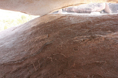
A pair of feet engraved on the floor. With this I was confident the inscription is close by.
Done with checking in the shelter, I thought of checking the outside. Yes! There it is. Thank the person who marked the engraving with chalk. I was happy we found it. Shivu was almost gawking at the letters ...he must be a real bad student.
inscription of Ashoka
A closer look at the inscription. I touch the engraving with my fingers ...Ashoka's message for peace.
Two short videos of the hooded rock and the inscription.

As imagined, getting down the steps was tricky with my palms and feet sweating like crazy. Mehboob helped me by lending a hand.

As seen from the other side.
Back in the car Shivya and Mehboob were arguing a great deal if this road linked to the road to Bahadhur Banda. Ignoring them, Ravi and I inquired with couple of passersby- yes, go straight and check directions at a junction. So Shivya was right.


Hooded rock coordinates: 15°20'14"N   76°9'43"E

.........

Jul 7, 2012

Koppal Fort

Some time 2003
I was traveling by bus from Hyderabad to Dharwad. On entering Karnataka, the route passed through Raichur, Koppal, Gadag.and Dharwad districts. At Raichur I got a glimpse of the fort from the bus-stand while I waited for a bus. At Koppal I was fascinated by the rocky hills. I promised to visit the town and climb the hills. Years later during my research on forts I learned about Koppal fort.
March 17, 2012

The journey from Dharwad to Koppal took about 2 hours and 30 minutes. The hill fort is visible from the main street of Koppal. Finding the way to the fort entrance was easy however driving through the narrow streets was not so easy. Anjaneya temple marked the beginning of fort area. At a street kids were curious to a car. On asking the way to fort entrance, one kid asked me if he could be a guide. That's exactly what I was looking for! Shivu was our guide at Koppal. We found a good spot to park Ravi's Indica. I asked him to stay in the car ...narrow streets, for some reason the car had to be moved.
The approach to the fort's gate at the base of the hill is filthy. I prefer not to describe it ...same problem with many of our forts. Conditions got better as we got closer to the first gateway. 

A concealed gateway Its partially damaged but overall the fort is in well preserved.

Koppala Kote

Different stages of the fort is visible from here. Looks like its a short climb to the top.

Stairway going up along the side of the hill. That's Shivu aka Shivya.

Looking back at the first gateway from the second gateway. The hillock in the picture below is a part of this fort. There's a bastion on that mound and rampart walls emerging from the bastion. To the left a water body is seen. That must be Moti Talab, a water tank just outside the fort walls.

Two flights of steps face each other. The one seen here goes up to a watch point and its a dead end.

As we emerge through the second gateway a water tank filled with green colored water is seen. There's evidence of recent restoration work carried out recently. We walk around the tank on a wide platform. In the background is the peak of this hill.

This is where a young man joined us- Mehboob. He had seen Shivu and me climbing up. His curiosity lead him here. Shivu showed me a inch diameter through hole in one of the dressed in the wall facing the town. Shivu demonstrates me how that hole was used to make a sound which could be heard at the base of this hill.

Slightly above the water tank level is another level with ruins of a mosque and two temples. One of the temples is dedicated to Yellammadevi, rituals are carried out regularly. The bastion in the mid top would be the highest point on this hill.

Looking towards the south. A watch tower can be seen in towards the bottom right. The fort was definitely well guarded. Bahadhur Banda fort is visible faintly on the horizon. When I asked Shivu and Mehboob if they can come to Bahadhur Banda. Yes!

Looking up at the bastion and the summit of this hill.

Gateway to this part of the fort is on the left. Pockets in rocks have been wisely used to store rain water. this portion has close to 5 such tanks. A trademark of Tipu Sultan. Sources say that Tipu Sultan captured Koppal fort in 1786 from Marathas. It is said that Mallasarja Desai of Kittur was imprisoned here by Tipu, however Mallasarja escapes from the prison. Koppal fort was very important to Tipu; with the help of French engineers he made it one of the strongest forts. Four years later i.e. in 1790 Tipu lost Koppal fort to British and Nizam forces. 

Very complex construction. The ditch to the right was used for capturing rain water. Notice the wall; its a dam across the gully. An inscription in Persian can be seen on the opposite wall. Mehboob's story: anyone reading the inscription will know the location of a hidden treasure but the reader's head will explode. Terrific. I assured these guys that seeking hidden treasure was not my interest.

Koppal's lake is hidden among hills. The lake's plan is three pointed. I feel this lake is a home to few migratory water birds. Breeze on this part of the hill was refreshing. At the base of the hill across the lake on the left are small cave formations. Mehboob mentioned they are used as gambling dens.

We reach the summit. The bastion offers a commanding view of the surroundings. Moti Talab is seen. To the left is the white painted stairway leading up to a Dargah. Top of this hill is supposed to be an inscription of Ashokan edicts. The inscription is called as Palaki Gundu inscription. But I wasn't sure of the location because my research showed a different location- very close to Gavimath. But Mehboob was quite confident of the location. Let's see.

The green patch in the center is the water tank on level 1. That's where Mehboob joined us. With watch points like this, surely the fort can be guarded well.

The summit bastion seen from the other side. There's another inscription on the rock face below the walls. Mehboob showed us 4 inscriptions, all Persian.

These walls were surely built during Tipu's rule. This design can be seen at Gummanayakanakote and Gudibandekote also. Notice two studs projecting out from the wall? Both studs have through holes running vertically. I asked Mehboob the purpose of those holes; flag staff is passed through them held there while the flag flies above.

One of the four inscriptions. Compared to Halegannada or Pali inscriptions definitely looks recent. The other difference is Halegannada, Pali or Marathi inscriptions are engraved but the Persian inscription here is embossed.

We spent a good deal of time. Thanks to Shivu and Mehboob- they showed me around nicely. I think Mehboob was pointing at Moti Talab.

All of us were hungry. We woke the sleeping Shivu and went in search of a canteen. We found one in the market area, it was a small one, idli was the only item on menu. Fine, we had idlis and tea. While at the canteen we asked the owner for directions for Palki Gundu. He wasn't sure, neither were to other customers. However one of them asked us to check out a hood shaped rock just behind Gavisiddeshwara Matha. We go in search of the hooded rock under which is Samrat Ashoka's edict.

PS: below pictures were shot during subsequent visits to Koppal.

Koppal fort as seen from Gavimath Gudda.

..as seen from Indrakeela Betta. In the background Bhadhur Banda fort is also visible.

Koppal fort coordinates: 15°20'18"N   76°8'59"E

.........