Aug 28, 2021

Khadi Kendra, Garag

June 28, 2021
Plan for the day was to meet a friend at Belur Industrial Area and then meet another friend at Jeeragiwad village. When Durga got to know about my plan she asked if she could join. That was a good idea because she would get to see a factory and rural life around Dharwad.
My friend, Mr. Sirdesai's factory is an ancillary to auto industry, aluminum-glass windows for buses and earth moving equipment are manufactured there. During the introductory chat, we got to know that Mr. Sirdesai and Durga were students of the same boarding school near Ooty. Their batches were a few decades apart, despite his seniority, the respect displayed by Mr. Sirdesai was profound. Durga got to see various aspects of production- raw material i.e. aluminum sections, glass & other stuff; machinery & plant layout; the assembly line, and a few finished goods. Mr. Sirdesai patiently explained and answered Durga's questions. I hadn't expected Durga to show interest in machines, the interaction was a pleasant surprise.
Next in our agenda was Jeeragiwad. On the way is Garag, the village where khadi cloth for our national flag is made. As we approached the village, I decided to visit Khadi & Yarn Production Center. This was one opportunity for Durga to see it, might as well use it. There are two Khadi and yarn production units at Garag both under the organization named Garag Kshetriya Seva Sangha. This is the entrance to the administration & production center. 

 Straight ahead is an yard enclosed by tile-roof buildings on four sides. The buildings are probably 50 years old. The one on the left houses the office and the remaining are production centers.

The simple office and humble office-bearers of a great organization which provides fabric for our national flag.

The office furniture too is traditional, so is the working culture. The cushions and covers are also Khadi. Photos of renowned Indian leaders adorn the office walls: Sardar Patel, Dr. Rajendra Prasad, M K Gandhi, Dr. Sarvepalli Radhakrishnan, Lal Bahadur Shastri and a few other eminent personalities.

The workshop has a supervisor's desk with a pair of weighing scales to measure the output of individual workers and quality control. Also there's an assortment of mechanical tools required for maintenance work of looms and spinning machines.

Two rows of handlooms facing each other is the standard layout here.

The inputs for each handloom is tightly spun khadi yarn which are perpendicular to each other mesh into each other producing the fabric. The workers have to match the output to given specifications. The yarns have to weigh certain grams for a given length. Same for the cloth- so many yarns per centimeter, and so many grams per square meter. The workers and supervisors have to be alert at all stages of the production because everything has to be monitored manually.

Here's a part view of the handloom operator's view. A marks the yarn in one direction (perpendicular to operator's view) and B is the fabric. A pair of wooden slats mesh the intersecting yarns tightly into each other producing the fabric.   

Shri Ekbote shows us a recently produced fabric. Each worker has a production target. As I know the fabric is sent to Gujarat Khadi Kendra where the fabric is dyed and flags are stitched. We had a tight schedule, so we did not delve into the details. We thanked the two office bearers here and left.

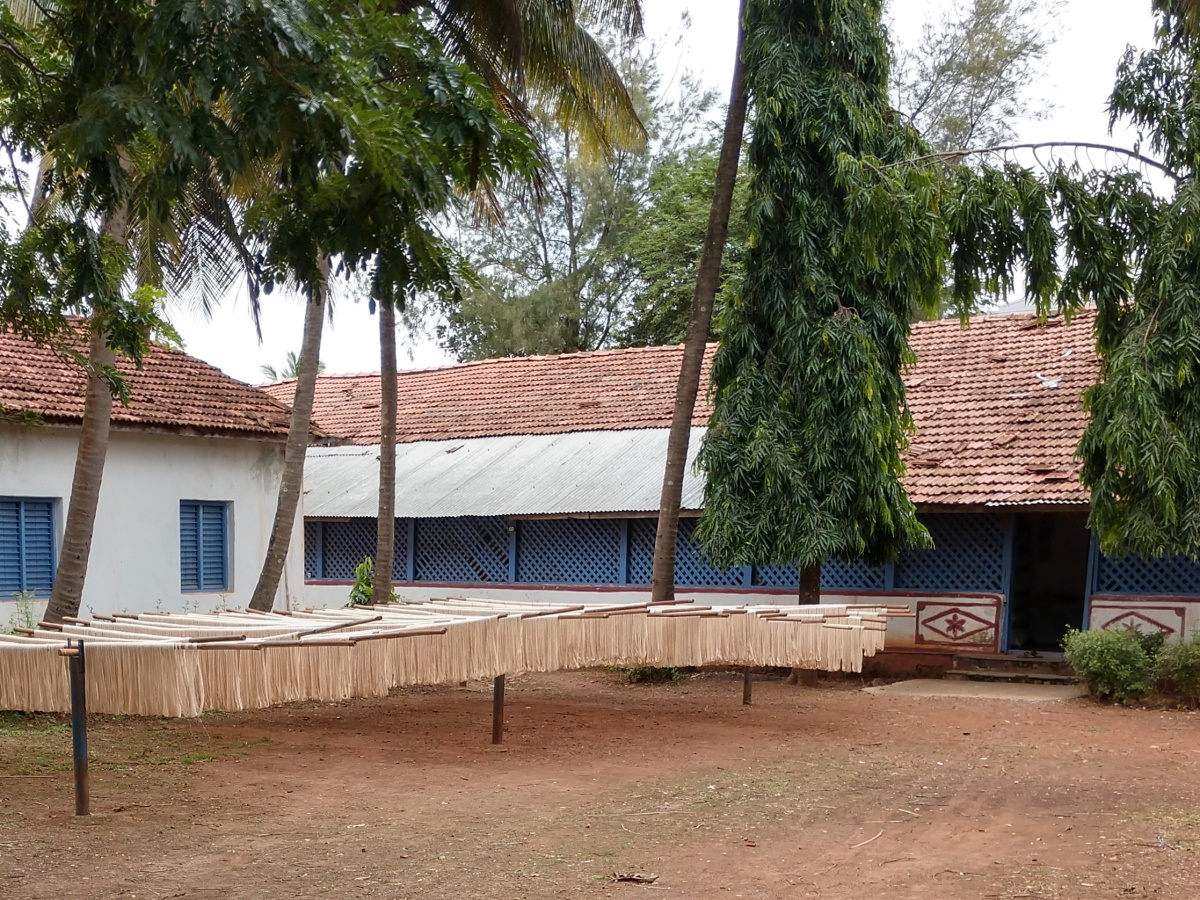
This is the scene at the other production unit which is about a kilometer away. These are the starched yarn hung outside for drying. I guess starch improves the yarn's bonding i.e. tensile strength.

The buildings at this unit are also old, probably 50+ years old. Situated on the outskirts, this place has a peaceful ambiance. Here, the supervisor was a man and yarn machines and looms were operated by women. The supervisor showed us various stages of the yarn making process. Originally cotton was made into yarns at Garag. For some reason the state government shifted that activity to a facility in Chitradurga which supplies the basic yarn to Garag unit. Here the basic yarn undergoes several iterations before it is ready for weaving.

Here are the three stages of the yarn. The bottom most is basic yarn and the top one is final.


Here's a short video which shows part of the process- 1. how the yarns are made and 2. weaving khadi fabric in a handloom.
Durga checks out a few colored yarns. Besides fabric for our national flag, fabric is also produced for kurtas, towels, napkins, handkerchiefs, and jamkhanas (large floor mats). 

This is the machine with which the smaller spools of yarns are transferred to a master spool. The tall stand holds around 192 small spools - all the tarn from these 192 spools is transferred to one master spool.

The supervisor gave a quick demo- he turns the lever which slows pulls the yarn from the stands and winds them around the master spool. The demo can be seen in the above video.

Here's one spool which is ready to be loaded on to a loom.

The humble peaceful handlooms. When in operation, the clickety clackety sounds are like music. One must see the ladies operate them to truly feel the beauty of the setup.

At one end of the handloom center sits this modern Charaka. I guess this is used to spin a tighter yarn rather than to produce yarn from cotton.

With this our short tour comes to an end. We thank the supervisor and leave.

Here's a flag I'd purchased from Garag Khadi Kendra late 90s. I had taken this Tiranga to Savandurga once, otherwise it's always at home. Tiranga of different sizes can be purchased from Khadi Kendra outlets at Dharwad. There are two in the market area- 1. near Gandhi Chowk on Subhas Road and 2. near Ram Mandir on Tikare Road.

Whenever you are at Dharwad on a weekday, try to visit Garag Khadi Kendra once. The place & its people deserve some attention.
.........

Aug 21, 2021

What to see in Chitradurga district?

Chitradurga district is one of the southern districts of Karnataka. The district is known for its rich mineral deposits, wind energy farms, a formidable fort, several prehistoric sites, 3/9 edicts of Samrat Ashoka are in Karnataka state, and there's one geological heritage site too. Chitradurga is one of the districts which shares it's border with neighboring state Andhra Pradesh. The district is bound by five districts i.e. Tumkur, Chikmagalur, Davangere & Ballari, and Anatapur district of Andhra Pradesh. Davanagere was formerly a part of Chitradurga district. The district consists of six taluqs namely Chitradurga, Hiriyur, Hosadurga, Holalkere, Challakere and Molakalmuru. The district's terrain is a mix of plain land scattered with dirt hills and rock hills. The major river of this district is Vedavathi and the dam in its path is Vani Vilas Sagar.
A few notable people of this district are- 1. S Nijalingappa a prominent politician, 2. TaRaSu (T R Subba Rao) a renowned author, 3. P R Thippeswamy an artist & writer, and 4. Tirumalai Krishnamacharya a Yoga & Ayurvedic guru.
For tourists the popular places are Chitradurga fort and Chandravalli. And for history enthusiasts there's a lot more.
Multi-level gateway near Murugha Matha | Fort walls
Grinding stones | Gopalaswamy Honda

Pillow Lava of Maradihalli | Jain temple next to Brahmagiri
Pond at Chandravalli | Prehistoric burial site near Brahmagiri

Jatinga Rameshwara hill | Ashokan edict of Brahmagiri
Ashokan edict of Siddapura

Here's a list of interesting places one could see, starting with the fort of seven rings.
Chitradurga fort - Chitradurga fort has the reputation of being one of the largest and strongest forts of Karnataka. Spread over several rock hills, the fort has seven tiers hence called the Elu Suttina Kallina Kote. Within the fort are several bastions & turrets, gateways, a secret passage, ruins of palaces and treasury, temples & a monastery, waterways & water storage tanks, a flour mill, granary and edible oil storage tanks carved into boulders. The fort was designed to hold off sieges for two years. Chitradurga was built between XI and XIII centuries in stages by Chalukyas, Hoysalas, Vijayanagara and Nayakas. During Madakari Nayaka's rule Hyder Ali laid siege which lasted a year. A secret passage, guarded by a lone soldier, was discovered by enemy soldiers who tried to make their way in. The infiltration of enemy soldiers was discovered by the guard's wife Obavva. The narrow passage allowed only one person a time. Obavva knocked out several soldiers with her pestle before she was overpowered. In honor of the brave woman, the secret passage has been dedicated to her as Obavvana Kindi. To the British people Chitradurga was known by the name Chittaldroog.
This fort is a popular tourist destination despite the tiring climbs one needs to endure. The fort has been a favorite for cinema makers too, the popular ones being Hamsa Geethe and Nagara Haavu. Below is a list of places within Chitradurga fort:
Apart from the fort, the other places of the district are listed below:
  1. Uchangi Yellamma Devastana - A temple built in Vijayanagara architecture in the outer fort area of Chitradurga.
  2. State Archaeological Museum - The mueseum has a collection of artifacts from prehistoric times such as Neolithic tools, weapons, pottery sherds, terracotta jewelry. The museum has a sizable collection of coins including gold coins from Vijayanagara times. Then there are sculptures ranging from X to XVIII Centuries collected from nearby villages and other parts of the district. The exhibits include modern paintings, palm leaf manuscripts, cannon balls and, arms & armory.
  3. Ramadurga fort - This hill is also known as Hosagudda and Hosadurga. Atop the hill is fort in ruined condition. The fort's stone walls and bastions are standing on three sides. A stone water tank can be seen in the center of the fort. The hill is popular for Sri Ramalingeshwara cave temple hence called Ramadurga. Hosagudda is about 36 km northeast of Chitradurga and 9 km south of Nayakanahatti.
  4. Thipperudra Swamy Devastana, Nayakanahatti - Thipperudra Swamy was a spiritual leader and a social reformer of the XV or XVI Century who's origin remains unknown. The name Thippe Rudra Swamy derives from the story of him performing meditation on a thippe ~ dump of agri waste and cow-dung which converts into manure. There are three shrines associated to Thipperudra Swamy namely Olamatha (residence), Ekanatha Matha (meditation retreat) and Horamatah (grave). Nayakanahatti is about 45 km northeast of Chitradurga.
  5. Chandravalli - is an important prehistoric site and also a religious site. Situated in a valley formed by the hills of Chitradurga, Jolagudda and Kirabanakallu. This place has several spectacular rock formations with caverns and a fresh water pond. Besides artifacts of Vijayanagara times, Roman and Chinese coins have been found here. The major attraction of this place is the subterranean temple known as Ankali Mataha. Chandravalli is 4 km south of Chitradurga fort. 
  6. Jogimatti - This is a hill range with forest cover. The name Jogimatti is derived from the tomb of an ancient ascetic named Jogi Siddeshwara. The tomb is situated atop a hill with spectacular rock formations. The place is popular for picnickers during rainy season when the entire hill is green and grey. Jogimatti shrine is 11 km south of Chitradurga.
  7. Adu Malleshwara Devastana - This is an ancient shrine dedicated to Shiva. Within the temple premises is a stepped water tank and a zoo. Adu Malleshwara Gudi is about 5.5 km southwest of Chitradurga fort. 
  8. Himvat Kedaya - This is a brook which flows out from the mouth of a Nandi idol inside a cavern. This place is also known by the name Himadagiri waterfall. The spot is about a kilometer southeast of Adu Malleshwara Devastana. 
  9. Megalithic burial site, Brahmagiri - Cist graves dating back to 900 BC have been discovered in the plains on the western side of Brahmagiri hill. Archaeologists have found that the graves show  astronomical orientation. The graves have been vandalised in the recent past yet the site remains important. Roppa village is about 100 km northeast of Chitradurga.  
  10. Ashokan edict, Siddapura - Emperor Ashoka embraced Buddhism after the Kalinga war. As a part of his mission to propogate peace had messages inscribed on rocks through out his empire which covered most of the Indian subcontinent. Of the surviving edicts, nine of them are within Karnataka state. Three of nine sites are located in Chitradurga district. The edict here is found on rock formations less than a kilometer from Siddapura village. Ashoka Siddapura is about 99 km northeast of Chitradurga.  
  11. Ashokan edict, Brahmagiri - A kilometer from Ashoka Siddapura is another Ashokan edict, situated at the northern base of Brahmagiri hill.    
  12. Ashokan edict, Jatinga-Rameshwara -  Jatinga-Rameshwara is a rock hill with its peak at 180 meters above the surrounding plains. This place is connected with Ramayana. It is here that Jatayu fell fighting with Ravana trying to rescue Sita. Atop the hill is a temple dedicate to Rameshwara and the inscription of Ashoka. Jatinga Rameshwara is about 18 km northwest of Ashoka Siddapura and 114 km northeast of Chitradurga. 
  13. Maari Kanive Dam & Vani Vilas Sagar - This is the reservoir created by a dam across river Vedavathi, a tributary of river Tungabhadra. The dam was was built between 1897 and 1907 by the kings of Mysore kingdom. Queen Kempa Nanjammani Vani Vilasa Sannidhana, the widow of king Chamaraaja Wadiyar was one of the promoters of this dam project. Also known as Maari Kanive project (named after a nearby village), this dam is 43m high. The reservoir irrigates about 100 sq km land. The dam and reservoir is situated about 20 km southwest of Hiriyur and 50 km south of Chitradurga. Close to the dam is Kanive Maaramma Devastana, a state tourism garden and forest department park. The forest dept park has a number of theme gardens of which one is Bruhat Panchavati Vana inside which is a group of the rare Krishna Ficus trees.
  14. Teru Malleshwara Devastana - this is an ancient shrine on the bank of river Vedavathi at Hiriyur. The Dravidian style temples seen here were built during Vijayanagara times. Hiriyur is about 42 kms southeast of Chitradurga.
  15. Gayatri Jalashaya - This is a small dam across river Suvarnamukhi near Kariyalla village in Hiriyur taluk. Suvarnamukhi is a tributary of river Vedavathi, they confluence at Koodalahalli. Kariyala is situated about 26 km southwest of Hiriyur and 66 km southeast of Chitradurga.
  16. Bayalu Ganapati Devastana, Holalkere - The main deity of this temple is a monolithic Ganapati approximately 20 feet tall. It is said that the idol was established in 1475 CE by  Guthyappa Nayaka.
  17. Sri Ontikambada Murugha Matha, Holalkere - This Lingayath monastery is a branch of Murugarajendra Brahmanata. The monastery is popular for its sprawling garden and stepped well which creates a peaceful ambiance.
  18. Raghavendra Swamy Anatha Sevashrama, Malladihalli - Raghavendra Swami (1890 to 1996) of Barkur village is the founder of this ashram. Raghavendra had served under a Siddharudha Swami of Hubli. He learned Ayurveda from Lakshman Das, a Yoga and Ayurveda scholar at Lahore. Jaggi Vasudev (Sadhguru) the founder of Isha Foundation was one of his disciples of this ashram. Malladihalli is about 50 km southwest of Chitradurga and 11 km west of Holalkere.
  19. Doddahotte Laxmi Ranganatha Swamy Devastana, Lokadolalu - The name of this shrine is derived from the big belly of the deity. The shrine is situated on a rocky hill which offers a beautiful view from the top. Lokadolalu is about 45 km southwest of Chitradurga and 15 km south of Holalkere.
  20. Molakalmuru silk weaving industry - Molakalmuru is a town close to Andhra-Karnataka border known for handwoven silk sarees. The saree weaving tradition here commenced a few decades ago. The sarees are woven by the Swakulasali community from Maharastra and Padmasali community of Andrapradesh. The patterns, motifs and designs are inspired by nature. These sarees received special patronage during Nalvadi Krishnarajendra Wadeyar's rule. Molakalmuru is about 90 km northeast of Chitradurga.
  21. Jagadguru Muruga Rajendra Brihanmatha - this is one of the major Lingayath monasteries. Also known as Murugi Matha, this monastery was established in the XVII Century. Murugi Matha has been lead by twenty four pontiffs starting with Sri Murige Swamiji I to the present Sri Shivamurthy Murugha Sharanaru. Murugi Matha is engaged in religious, social, educational and cultural activities which is of great value to the society. Within the Matha premises is Muruga Vana, a garden with lifesize sculptures of humans, animals and other scenes. The collection of animal sculptures include dinosurs. The Matha is situated on the outskirts of Chitradurga, off Bangalore-Poona highway.
  22. Dasaratha Rameshwara Punyakshetra, Doddavajra - This is an ancient shrine connected to the epic Ramayana. It is beleived that this is the spot where king Dasharatha killed Shravanakumar in the darkness mistaking him for an animal. The shrine is situated in the cleft of a hill. This peaceful place has a natural source of fresh water and temple. Doddavajra is about 88 km south of Chitradurga and 48 km southwest of Hiriyur.
  23. Halu Rameshwara Punyakshetra - This is another place associated with Ramayana. It is believed that Rama installed and worshipped Shivalinga here while going to Srilanka to rescue Sita. Apart from the Shivalinga, the place has two natural sources of water namely Udbhava Gange and Varava Koduva Bavi. The latter is a well, its water is white colored like milk. Hence the name Halu (milk) Rameshwara. Halurameshwara is about 12 km northeast of Hosadurga and 60 km southwest of Chitradurga.
  24. Taralabalu Jagadguru Brihanmath, Sirigere - this is another large Lingayath monastery which was founded by Marulasiddha in the XII Century CE. It is said that Marulasiddha blessed his successor by uttering "Taralabalu" which means "long live my child" and that is how the monastery's name came by. Sirigere Matha manages a number of educational institutions and carries out social activities. The present pontiff is Dr. Shivamurthy Shivacharya Mahaswamiji. Sirigere is about 25 km west of Chitradurga, about 6 km west of NH48.
  25. Pillow Lava Rocks, Maradihalli - Pillow lava rocks are formed when submarine volcano lava comes in contact with seawater. The result of sudden chilling is bulbous or pillow shaped structures. They are flat bottomed and convex topped with thin glassy margin. These rocks of Maradihalli were first recognized by Dr. C S Pichamuthu, Director of Mines and Geology Department. Maradihali is situated between Chitradurga and Hiriyur, close to NH48, about 20 km southeast of Chitradurga.
  26. Laxmi Narasimha Swamy Devastana, Horakeredevapura - This is a 800 year old temple originally built by Chola kings, it was later developed by Palegars and Nayaka rulers. It is believed that Lord Laxmi Narasimha came here from Tirupati in three steps only. Horakeredevapura is 30 km south of Chitradurga and 50 km west of Hiriyur. 

Aug 14, 2021

Mandaragiri - part 3

 ...continued from Mandaragiri - part 2.

In the earlier two parts I'd covered the hill climb, the temple enclosure, rainwater harvesting ponds and an aerial view of Mydala Kere. The last item to see is this Mantapa built in front of a boulder.

This is a marvelous creation. The framework is ready, roof is missing. The Mantapa has 14 pillars supporting the beams, and two more free standing. Going by the looks of the pillars, a grand Mantapa had been planned here.

The idol, rather the remains of the idol which is part of the boulder itself. Going by the colors of the stones, the damage seems to be recent.

A closer look at the idol. It looks like a man on a seat, sitting in Padmasana, probably engrossed in Dhyana. It seems like a Jain Theerthankara's idol. The part above the head must've been an serpent hood. The three lions below the seat seems like Hoysala design.. there's a good chance this was sculpted during Hoysala reign. On the top-right, within the frame of the sculpture, are three bas-reliefs which appears like flowers but are not. Lets take a closer look at them..

The closeups of the three works.. they are palms, two individual and one pair. In Hindu culture downturned palm of left hand is called Varada Hasta or Varada Mudra. Usually its an empty palm. An upward pointing palm is called Abhaya Hasta or Abhaya Mudra. While Varada Mudra signifies granting a boon, Abhaya Mudra is a gesture of protection & reassurance. In the picture below the pair of Varada Hasta has something in it.. can't say what it is.

View of the Mantapa in the opposite direction. Notice the small pits on the left hand side column. I remember seeing the pits only on this face of the pillar. No idea how such pits are made without disturbing the surrounding material. I guess this was meant to be a meditation hall. For some reason it remained incomplete without a roof.

Two date palm, all alone in this hill. Looks like someone here had discarded seeds which germinated, took roots and grew into handsome date palms. 

Taking a second look at the rainwater harvesting pond. The pond could be 5' deep and 40' in diameter. Probably the water stays fresh through out the year. The pond has a overflow arrangement on the left hand side i.e. water flows out on the rock so that the mud bank is not eroded.

The huge boulder seen earlier.. one face is covered with a painting of three anthropomorphic images. Since the painting measuring approximately 10' wide and 12' high has faded. I'm guessing the three figures are Jain Theerthankara. Whoever the artist was (artists were) had taken up a challenging work.

Wish I could spend one or two more hours exploring the hill and lake but decided against it. Hunger was one reason, and the other was not to get stuck in peak hour traffic while entering Bangalore. The descent was quick, probably five minutes. People of Tumkur are lucky to have these wonderful hills, so many getaways, so much to explore. However, expanding cities- Bangalore and Tumkur -are wrecking havoc. Its scary to think how this place will be in the next 10 or 15 years.

This building here is close to the base of Mandaragiri. It is shaped like a peacock feather fan, the type Jain monks carry to brush away insects in their path. From the looks, it seems like a meditation hall. The hall was closed, so was the gate in the fence. Probably the management had shut the place due to Covid restrictions. I was wondering if the interior was plain or special like its exterior. Anyway, I decided to have lunch here since the place was peaceful.

Found a cool spot close by, freshened up with a quick face wash, and finished off the remaining chapati, tomato curry & cucumbers. Hunger taken care of, I was ready to continue my journey.

One last looks at Mandaragiri. Lovely place!

.........

Aug 7, 2021

Mandaaragiri - part 2

...continued from Mandaaragiri - part 1.

In the first part, the stairway on the southern face of Mandaragiri was covered. Also the exterior of the temple enclosure at the hill top, a pond and few natural boulders. The hill has a nice view of the man made lake called Mydala Kere adjoining the hill. Now we move on to the second pond for harvesting rainwater. Across the pond is an open temple with its deity sculpted on the boulder. A very unique temple this is. May be, instead of temple, I should call it a Mantapa.

The almost placid water surface creates a lovely reflection of the Mantapa. One could sit and stare at this scene as long as the reflection lasts.

The clumps of grass is what caught my attention here. This type of grass is usually seen after rains in rocky hills across Karnataka and Andhra Pradesh. The jigsaw stone is a naturally shattered boulder. This may not be granite, it could be sandstone. This reminds me of the smaller jigsaw at Kumbi Betta near Huliyur Durga,

The temple enclosure as seen from the jigsaw boulder. This is a good place for trekking.. just form your route on the fly.

Panning to the right, the boulder shrine comes into view. The two date palm trees are a nice touch to this scene. Its like adding salt & pepper on your omelet.  Taking about treks, one could actually walk bare foot here.

The stone-water-triangle of Madaragiri and Mydala Kere. Beyond the lake are the hills of Devarayanadurga. The rock formation on the right is marked as Sumitra Betta in Google Maps. I have no idea what's the story behind the name of that mound.

Mydala Kere is a man made reservoir. On the left hand side is the man-made bund (earthen dam) which holds the water. The other shores of the lake are natural slopes.

The bund is clearly visible in this picture. It is about 750 meters long. I'm guessing this reservoir was made any time between Vijayanagara times and British rule. The reservoir, 1.5 km at its widest point and 1.5 km at its longest point, seems three fourths full. With more rains the water level could rise further.

Looking back towards the Jain temple and the boulder.

This is the track which runs around this hill. Those who wish to ride or drive up here have to take the road starting at the arch (near the base of the stairway). After rains the road can be a little rough. But that should be okay for two wheelers and SUVs.

Another interesting rock in the vicinity. The shy palm is hiding behind its friend.

This road might be developed in a few years. I hope its left as it is for the sake of natural beauty.

After a short exploration, I head back towards the temple. One thing remains to be seen is the sculpture on the other face of this rock and, the Mantapa.

The reminder of the article will continue in Mandaaragiri - part 3.

.........