Jan 29, 2022

Fort Machigad part-1

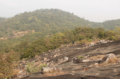
Machigad is one of the small hill forts of Belgavi district. It is about 4 kilometers from Halasi. Machigad hill and Raamteerth hill are part of one group of hills. Machigad is the highest hill of the group. The hill seen in the below picture is Machigad, the fort ruins are concealed in the thick vegetation. This is the view of Machigad as seen from Raamteerth. As you see the hills are joined. In fact there's a direct route from Raamteerth to Machigad fort through the jungle. Only a local who has traveled in that path will be able to guide.

December 15, 2021
My day started with a trek to Raamteerth which is about 4.5 km from Halasi. By the time my trek ended and I returned to my car it was around 11-15. I had breakfast and contemplated the next destination- Machigad or BhuVaraha Devastana at Halasi. I decided to check out Machigad. I'll climb the hill if the trek was short and if a guide was found.

At Machigad, I happened to meet two gentlemen named Rajaram Shinde and Rajaram Hanabar. The latter appointed his son Kalmeshwar as my guide. This is Kalmeshwar leading me to Machigad fort. These steps were laid out recently so that people can ascend the hill comfortably. People here usually go up to the Mata Mandir inside the fort premises.


The steps ended in 5 minutes. From here steps have been made into the dirt, slabs will be laid out soon. I was trying to imagine the dirt path without steps... it could be slippery even during dry weather and perilous during rains. 

The dirt steps too ended a few minutes later, then it was just dirt path but not too steep. At one point the village comes into view. The cement road is the approach to the fort, my car was parked at the end of road in the village.

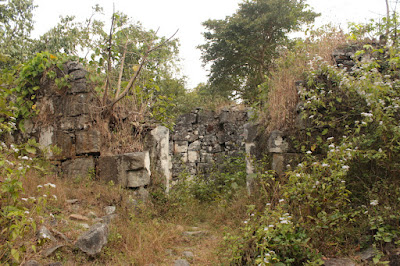
As we climbed higher there were two or three hairpin bends in the path. Most of the way the path was flanked by walls of vegetation. Then suddenly the ruins were seen. The entire climb- from the village to the fort gate lasted 11 minutes. The walls are made of semi-finished granite blocks, probably sourced from this hill and also brought from Raamteerth side. Kalmeshwar waits while I take a few pictures. Only a hundred feet of wall is seen, the rest is lost into the vegetation.

Its a zigzag path into the fort. The walls, though made of rough cut blocks have a plain surface so that they are not scalable easily. The approximate age of these ruins could be 500 to 800 years. They have withstood the test of Nature. This hill can be very damp and wet during rainy season, yet the walls are almost intact.

Close to the fort entrance, on the left hand side is a shrine dedicated to Hanuman (see inset). Its a rule that every fort has a Hanuman shrine as a mark of strength and valor. Kalmesh removed his sandals at a distance, went to the shrine, removed dried flowers and did Namaskara to Hanuman. I guess all people of this village are quite religious here.

This is the second or the inner entrance. The distance between the two gateways could be 80 feet. I'm trying to imagine the massive wooden gates manning these passages. Probably the entrances had arches as well, which are not seen now.

The other side of the inner entrance. Seems like the inner walls are more damaged than the outer walls.

This is the second shrine of this fort. This little temple is dedicated to Mata Durga. Kalmeshwar went inside the temple, swept the floor clean, did Namaskara to Mata. He seemed so genuine with his emotions when it came to religious matters.

Next we head towards northern side passing over this rock. Kalmeshwar wanted me to see his village from here.

That's most of Machigad. The village is surrounded by paddy fields. Most people here speak Kannada and Marathi. We see lot of RCC houses now but if we go back 20 years we would've seen mostly tiled roof houses.

Kalmeshwar is doing PUC II in science. He has plans to do BCA. I felt it was a good choice. He said that he and friends spent their holidays on the hill.. this spot below is one of their favorites because of the view it offers. He said this spot was too good for photo shoots. Yes, he was right!

A bed of rock and an open view of the surroundings. It was a hazy day, clouds of mist shrouded the hills and plains. I liked the ambiance of this spot. However, we did not stop any place for long.

Raamteerth was visible from the spot. However, trees in the foreground blocked the view. Kalmeshwar said there's another spot which gives a clearer view of Raamteerth. We would be heading there next.

The photo shoot spot. Indeed its lovely.
The granite bed had lot of white bands on its surface. Must check out how these bands occur when the stone is formed.

Kalmeshwar led and I followed. He knew this fort like the back of his hand. The terrain was uneven, up & down, twists & turns, we had to bend to dodge thorny branches... it was a good exercise.

Then suddenly this marvelous little tank came into view. A hollow created by hacking out tons of stone. The tank must be 10' long, 7 ' wide and 6' deep which means its capacity is 11800 liters. Water was little greenish, that's because of the moss at the bottom. There was no odor as such. It seems this becomes a swimming pool for village boys during summers.

Rock-cut water tanks are wonderful creations. It may not be as easy as it seems. The stone workers need to know how deep the stone is. Wonder how they found out. And, I think this work was assigned to apprentices under close supervision. The other forts which have rock-cut tanks are Chitradurga fort and Chandragutti fort.

We has seen approximately half the fort. The tour will continue in the following post - Fort Machigad part-2.
.........

Jan 22, 2022

trek to Sri Ramlingeshwara Devastana part-4

...continued from trek to Sri Ramlingeshwara Devastana part-3.

The previous three parts were about the 4 km trek through paddy fields, jungle path passing over hills and through jungle. Raamtheerth, a group of three shrines & a water pond, sits on the highest point of a rock hill which is accessible from one side i.e. the northern side. The other sides of the hill are steep and not safe for climbing. Adjacent to Raamtheerth hill, on the northeastern side is Machigad ~ a hill with a fort dating back to Chatrapathi Shivaji's time, probably even more older.

To the west are some plain land in between hills. Any plain land available here is mostly a paddy field because that's the only crop that grows in water-logged land. In the foreground is the western slop of Raamtheerth hill. That's one of the few massive boulders on this hill. The surface's dark color is due to dry moss. This is a part of the western ghats, when it rains here, it pours.

Even in dry season one needs to be careful while moving on these slopes. What appears to be rough enough may not be, especially when the rocks are warm under bright sun.

This is the southwestern slope. The mound seen on the right is the neighboring hill who's slopes are wooded and its summit is a plateau. On the left  hand side is a projecting rock. Its a huge rock, a number of people could actually stand on the overhanging part without disturbing the equilibrium.

About 60 meters from the temple are these two slabs. They seems like dressed stones. Probably the temple builder had planned to construct a small temple here. For that purpose a level surface was needed. Somehow the project was abandoned.

The slab as seen from above. More of the neighboring hill is visible here - it looks interesting, a place to be explore some day.

The rock with a overhang. During our previous visit, my companions stood on the rock for a photo. I could see they were not sure of the rock's stability, they were scared yet wanted a photo there. To see pictures of my previous visit click on Ramtheerth visit October 2010.


A natural niche and a pit. This pit would be filled with clean water during rainy season, a perfect home for tadpoles. Also a neat little pond for bird to bathe.

Of all the boulders here, this is the most prominent. The rock looks like a tortoise head, may be a lizard head. Its been sitting there for god know how many millennia. I don't think the temple builders tried to quarry stone from this boulder. Below the rock is a nice space for people to rest on a sunny morning. Also, the rock is scalable, one could clamber on to the top for a different view of the temple & surroundings.

Next to the tortoise rock are veins in stone. I've seen bands in granite in many places, seen wall like formations in igneous rocks at Sidlapadi, but I can't recall seeing anything like this before. These veins are about 2" wide and high. Similar veins were seen at a smaller rock formation on the trial leading to the temples. Those lines were random but here we have three long parallel lines and one short diagonal line. 

Close to the tortoise rock is this boulder which was targeted to be broken to make pillars or beams. The line of square holes is the first step in splitting a stone with a plain face. These holes are 3 to 5 inches deep. As I heard- hot water is poured into these holes which will create a crack connecting these holes and the boulder splits with an almost straight edge. This method of splitting stones is in practice even to this day.

That whitish rock in the center of the picture is the overhanging rock. 

The shelter created by tortoise rock. Its quite a big space, 15 to 20 people can easily sit here.

The pile of rocks on the right seemed to be broken by humans , probably for making blocks for temple construction.

The tortoise rock as seen from the opposite side. The main boulder and the pieces lying below might have been one huge piece. How is broke is something I'm pondering about. Did it split naturally or did humans intervene, May be a geologist would be able to get some clues by studying the pictures or visiting the site.

The tortoise rock is a part of a bigger cluster. Probably all these boulders was one huge unit ages ago. Stones, with time, breakup like families. One becomes two, two becomes five, five to ten, on and on. In the course they suffer erosion as well. A freshly split stone may have sharp edges which rounds off over time. Then they split, erode and roundoff. Philosophically speaking, when a change happens its looks different, sticks out. However with time the change normalizes.

There's a lot more to see here. One could spend an entire day looking around and taking pictures. BTW, I was the only human being on the entire hill. I think the closest human being would be at least a kilometer away. This, solitude, is something one needs to experience. I've experienced the same at Savandurga and Chandrgutti fort.

 I decided to call it a visit, and move on. I had two more places on the itinerary for the day. So, one last look at Ramlingeshwar Devastana.

The trek was easier since it was downhill most of the way until this point where the paddy fields begin. One more last look at the hill and the faintly visible temple. 

And I turned around to continue my trek, I saw a line of women with sickles in their hands. They had finished their morning chores at homes and now they are ready for working in the fields. Once they are done for the day at the fields, they go back home and take care of another set of chores. Oh man, do they ever rest!

I was famished when my car came into sight. I just grabbed the bag with food stuff, found a spot in a field and attacked. After the first chapati, my mind started functioning... where should I go next- Machigad or Halisi. Machigad means another hill climb. Okay, let me go to Machigad and find out how the climb is, then come some other day to climb the hill. So with that plan, I ended by morning meal, ready to head to Machigad.
.........

Jan 15, 2022

trek to Sri Ramlingeshwara Devastana part-3

Part-1 and Part-2 of this article covered the walk to Ramteerth and an overall look of the temple site. We have 3 temples here- two temples are close together, and the third one is a stone's throw away. These two are the main temples whose construction seems complete.

The third temple which stands about 70 to 80 feet away is incomplete even though there's a Shivalinga idol in the sanctum. As you see only the Garbhagudi walls are done. The Antharala walls are still incomplete. The entire structure lacks any kind of roof. Also, as per my observations there are no inscriptions at the site.

The smaller temple is not really small. The front porch itself is six feet high. Overall the temple could be 13' to 14' high. The 'porch' can be considered as a Mukhamantapa which connects directly to the Garbhagudi. I'm guessing this temple was constructed first and then the bigger temple.

Architecturally both temples are same, The Shikhara are stepped and tapered. The Shikhara crown are similar, may be the sizes are different. Lets go around the temple once.

The ground behind the temple slopes down giving an interesting view. Usually temples are built on level ground but this site is quite special in that aspect. Talking of the terrain, one must see the temple on a ledge of a sandstone hill near Gajendragad which is a Chalukyan creation.

Like I said the ground really is steep. Directly behind the temple is a layer of dirt and boulders covering the monolith below. Rest of the hill is mostly exposed rock.

On the right hand side of the temple there's a layer of dirt. I feel this dirt bank was man-made to facilitate a flower garden for the shrine.

The temple, pond and garden area.
This temple has three entrances one each on the eastern, southern and northern sides. Unlike other Kadamba temples, this temple doesn't have balustrades at the entrances, instead a pair of platforms flank the passage. The temple floor is also raised from the rock-bed. This entrance seen here is the southern.

Stepping into the temple ...this is the view of the Antharala (vestibule connecting the Sabhamantapa and Garbhagudi) through the Sabhmantapa. The columns appear whitish- that's the remaining coat of lime. I hope someone scrubs the lime away and restore the original stone look. At the vestibule entrance are four pillars, one pair of bigger pillars and the inner pair are slimmer. The slimmer pair of pillars reminds me of Uttarakumara Gudi at Tambur village which also is a Kadamba creation.

A diagonal view of the Sabhmantapa. Flanking the Antharala entrance are four niches, two on each side. Inside the niches are idols of other gods.. Ganesha, Nagadevas & few others I couldn't recognise.

The Garbhagudi frame is simple, however the floor just next to the threshold is decorated with floral art in stone. Also a little idol of Basavanna sits on the vestibule floor. The idol looks quite crude, meaning the features aren't sharp. It is said that ancient sculptors sculpted idols of Nandi in a single day i.e. from dawn to dusk irrespective of the physical size. This I heard first at Lepakshi from a local guide. In case anything remains, its left incomplete for good.

The Ramlinga. During my first visit here i.e. Jan 2010 it was Sankranti day. A few local men were performing pooje in a traditional way. The idol and Garbhagudi were washed with water, idol adorned with a garland of white flowers, an oil lamp glowing softly and incense burning. I think the men gave me pooja prasad. This time the Garbhagudi was clean but no flowers as such. I got a few Thumbe flowers and placed them on the main deity and other idols too.

This is the view of the eastern side from the Antharala. Just next to the eastern entrance is the water pond. When the water level is at its highest it could be just 2 or 3 below the temple floor. With this I'm done seeing the temple. I move on to the third temple, the incomplete one.

This is one picture in which all three temples are visible separately i.e. their views are not overlapping. In the background is Machigad hill, amongst the thick vegetation are ruins of an ancient fort. The third temple was still in the early stage. I think the construction went on stages like this- 1. Garbhagudi, Antharala & Shikhara, and 2. add a Mukhamantapa. 


Side view of the third temple. Like most small & medium temple built by the Kadambas the exterior walls are plain. The temples are well built and elegant seven though they have plain looking walls. The Shikhara is what takes care of the temple's beauty. To name a few temples of Kadamba in this region-
  1. Halasi group of temples
  2. Thatteshwar Mahadev Gudi near Nandgad
  3. temples at Sonda fort
  4. Uttarakumara Gudi near Tambur
  5. temples on the banks of Haliyal fort water tank
The front-side view. None of these temples required a foundation because they were built on a rock hill. I think the rulers & temple builders had plans to construct more temples here. Every new king may be obligated to have a temple built. For that matter not just kings, even ministers or army chiefs or rich merchants had temples built. For some reason the site became dormant but good thing is that the temples are well preserved.

The front view. The planned size of this temple seems to be same as the main temple here.
The deity is another Linga. Not sure if it's called Ramlinga or Shivalinga. Since this place is called Ramtheerth this could be another Ramlinga. Looking at this temple, I feel ancient builders installed the deity first and then built the structure around it.

In the water pond is a small collection of idols. The largest piece here is a piece of the Shikhara, which is fixed in the front like a forehead. On the far left is an incomplete and damaged sculpture of Vishnu. The idol on the right is a standing Eshwara holding a Trishula. The idol is damaged hence its not used for worship. Apart from these idols, I haven't seen any other pieces of sculptures here.

Having done wit the temples, we can now check out the surroundings... rocks, hill slopes, other hills and paddy fields in the plains below. A very interesting landscape here. If it were earlier, around sunrise, there's a possibility of seeing some interesting birds. 

We'll check out the natural beauty of Ramtheerth in the following post- trek to Sri Ramlingeshwara Devastana part-4.
.........