Ram Teerth or Ramalingeshwar Devalaya is an ancient shrine situated in a rock hill near a historical village Halasi situated in the Malnad region. The shrine is surely a prehistoric one, the temple structure is said to be built by Kadamba kings. At Ramteerth is a water pond and three temples, two completed and one incomplete. Since the location is remote the temples have been preserved well, the place has a peaceful ambiance. For anyone who want to perform pooje in peace this is a great place.

It was several months since I travelled away from Dharwad. One Sunday I decided to revisit Halisi & Ramtheerth. I added Kalmeshwar Gudi near Bidi village and Machigad fort to the itinerary. All these places are within a diameter of 10 km. My plan was to visit Ramtheerth first followed by Machigad and then the remaining places.
December 15, 2021.
I left home by 7-15 am. Drove to Kittur, turned left towards Bidi. At Bidi, I took the short cut road to Nandgadh, on this road there's a cross road, a left turn here will lead straight to Halisi village. Drive through the village to the other end which hits a state highway (Ramnagar-Khanapur road). At this junction, I turned left and almost immediately turned right into a dirt road. About 350 meters on the dirt road is a foot-path leading into farmlands. That's where I parked my car and prepared to trek. That tree seen in this picture is the starting point.

The hazy hill in the background is my destination. I was standing here again after 11 years. The place seems unchanged. My previous two visits were in March and October 2010. During March, the fields were barren and October paddy was almost ready for harvest. I think harvesting happens in November & December. Besides this dirt path, there are other roads to reach the fields inside.

Rocky outcrops as this enhance the beauty of this place. These rocks have a dark surface except for patches of white which is due to human contact. Crowds throng Ramteerth during the annual fair and Maha Shivaratri. Kids and probably teens slide on these rocks hence the white strips.

The soil is quite hard, it holds well even in wet conditions. This property of the soil is helpful to build banks to retain water. Paddy crop needs to stand in water for several months. Once the grains are formed, water is drained out. As you see, only rows of stubs are seen which means paddy has been harvested. This is another interesting rock formation. I think this serves as watch tower to shoo away birds which come to feed on grains.

The rock formation as seen from the other side.

Further into the fields banavi ~ hay stacks come into view. Hay is a byproduct of harvest. Usually farmers send grains with husk to rice mills or store it in their homes. Hay is either fed to cattle or sold. Besides feeding cattle hay is used as packing material by fruit merchants.

The foot patch is barely a foot wide. Now and then there are black ant crossings ..have to watch out for them and step over carefully. The other thing commonly seen are spiderwebs on the ground. Since the sun was still behind clouds most spiderwebs were covered in dew drops.

A huge rocky mound comes into view. These rocks are covered with interesting flora. For those into macro photography this place offers a wide range of subjects, both flora and fauna.

Here the path passes over a narrow mud wall between two plots. When crop is still standing, one needs to tread carefully lest a foot lands on the sides. This is the last I saw another human being until I came back to this spot on the way back.

Battada Gadde ~ paddy plots as far as the eyes can see. During my second visit these plots were one huge green carpet. A farmer in white clothing was inspecting this crop's health. Farmers are such hardworking folks, they deserve better facilities, at least during sowing and harvesting seasons they need lot of support.

From this point on the terrain changes, its more of rocks hence no fields here. I'm not sure if these trees have grown naturally or of they were planted by forest department. A few places there are eucalyptus which means they have been planted by farmers or forest department.

No other human in sight. So peaceful. However, visitors have left behind trash... bottles and sachets. Next time I'll come with printed boards asking visitors not to litter. The boards have to be in three or four languages ...Kannada, Marathi, Hindi and English.

Here the path becomes really narrow with grass falling from both sides. In the middle of the path is a pair of boulders with a small gap. The spot is like a perfect ambush spot.

The passage between the rocks and the ambush point. Further up the road there are a few more sharp turns with blind spots. They too are good ambush spots.

The path then moves into open space. Here the hill slopes are covered with grass, the type with black thorny seeds which cling on trouser fabric. They won't fall off, they have to be pulled out.

The path is more or less level for some distance until few more farm plots come into view. A few plots with standing crop left for the season.

This needs to be harvested quickly else the grains will dry way too far and drop off. Harvesting has to be done while it still has moisture in them,

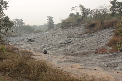
This quarry is a major landmark in the route. I assumed this was an inactive quarry. No, its an active one but thankfully the rate of extraction is kept low.
From here the path enters the jungle and also on the neighboring hill which happens to be Machigad.
Click on trek to Sri Ramlingeshwara Devastana part-2 to continue reading this article.


No comments:
Post a Comment