Oct 30, 2021

Nandi and Hanuman of Savandurga

Savandurga is first known for its size- one of the largest monoliths of Asia. Then its known for its fortifications which are spread over the two hills (Biligudda and Karigudda) and also on the sprawling rock bed at the base of the hill. The other noticeable manmade item on Savandurga is Nandi Mantapa standing at the summit of Karigudda. The four pillared and  crowned structure can be seen from the base of the hill itself. Here's one picture of the monolith shot from a kilometer away. At the tip of the peak is a speck. That speck is Nandi Mantapa.
sometime 1995
Once you start ascending the hill, it goes out of sight until you reach the top of Karigudda. The tip of Nandi Mantapa Shikhara is visible from a point close to the start of a narrow path passing between and under huge rocks. This is my cousin Ashwini standing with two boys we met during the climb some time early 2000s.
The following pictures were shot on Aug-17-2011. Deepak, Vijay (Deepak's colleague) and I had reached Savandurga at 6-30. It was rainy season, the hill was wet and shrouded in mist. This is the rear of the Mantapa. Nandi facing away, looking towards his Lord somewhere far away. During my first visit the Mantapa was in its original form, plain stone look. Someone decided to cover it with a thick layer of lime which wasn't necessary. The Shikhara is brick & mortar, a coating of lime helps preserve it. But lime has a damaging effect on stone. Hoping the people here realize it and remove the lime somehow.
Most of climbs are nonstop. We pause to catch our breath but never sit down until we reach this spot. The moment I reach the Nandi Mantapa, I climb onto it, touch Nandi and then take rest. This spot has its moods depending on the conditions... sunrise, sunny, cloudy, misty, windy. It feels most serene when its misty,. That's Deepak staring into the mist, listening to the sound of silence, as though in a trance.

Here's a closer view of Nandi sitting in his Mantapa. The architecture of the Mantapa is Vijayanagara. It's a well built structure to have stood there centuries absorbing the forces of Nature.. heat, cold, rainwater, mist and wind.
I would like share another picture of Nandi Mantapa, shot in Dec-2007 during my fifth overnight stay atop Savandurga. The Mantapa is seen in early morning light. Imagine the scene minus the flag pole and electric pole.
Every fort in the Indian subcontinent has a shrine dedicated to Lord Hanuman known for his perseverance, pragmatism, strength, sense of humor and selflessness, loyalty & humility. The idol could be small or big, but you'll find one shrine at least. Savandurga too has a shrine dedicated to our god of strength. The idol is sculpted on a rock, facing northerly direction. The idol is unknown many since it is off the main path. During rainy season the narrow path is slippery and hidden behind vegetation. With a little effort one can reach the shrine.
There's our lord in company with Sun and Moon. This is the pose in which Hanuman is usually seen. The lord's disciples have painted the image which is not really required. The natural look of stone is most beautiful.
Here's an older image of the lord, probably 2004, shot in dry weather.
To my knowledge these are the two shrines on Karigudda. I've heard there's a shrine dedicate to Ganesha on Biligudda which is visited once a year by the people of surrounding villages. Then there are temples dedicated to Veerabhadreshwara and Laxminarasimha at the base.
.........

Oct 27, 2021

inverse crescent

This picture was shared on a Whatsapp group, it caught my attention, it is a unique capture. The beauty of the picture is the inverse crescent created by the massive pipe. 

they r planng to fix d tunnel where LIGHT starts

The email which delivered the original picture came with the subject line "they r planng to fix d tunnel where LIGHT starts." What an amazing thought. This is a morphed version of  the age old saying "there's light at the end of the tunnel." Thanks to Anil Prasad for the picture & caption.

Coming to the pipe & truck. The pipe is almost twice as wide as the truck ...approximately 5m in diameter. It could be weighing a few tons. Transporting it not a easy task given the chances of the pipe rolling because of inclined road surface or a strong gust of wind or the harness giving away ...touch wood. Surely this task would be assigned to a highly experienced driver. The truck was seen plying near Dobbaspet, between Tumkur and Bengaluru.Hope the truck has reached the destination safely.
.........

Oct 23, 2021

floating with the clouds

This visit here was with Rajesh, my colleague in 2000s. We had explored Basavanadurga the previous afternoon and stayed overnight at Veerabhadreshwara Devastana. We woke up early and climbed Savandurga's Karigudda while the weather was pleasant.

This is one of the best scenes I saw at the summit i.e. neat to Basava Mantapa. These clouds moved in gradually engulfing the entire surrounding. It felt as though we were afloat in the sky. This dog which had accompanied us through out the ascent sat there watching the clouds. Probably it was wondering if it could hop over the clouds and find a bone somewhere :) The floating illusion lasted about 30 minutes.
.........

Oct 16, 2021

Basavanadurga, the lower fort of Savandurga

For those who've seen Savandurga, its a huge monolith. In fact the largest monolithic hill in Asia. The monstrous size of the rock is so dominant that the ruins of fort on the hill goes into the background. If you focus on the fortification aspect of the hill, one can be surprised. The fortifications are spread across a wide area and elevations. The fortifications are spread over the two hills and also over the sprawling rock-bed on the southern side of the peaks. The elevation of the rock-bed is hardly 15% of the main peaks. The rock-bed is quite uneven with a few naturally formed water ponds. Unlike the main hill exploring these ruins is not a strenuous activity.

My visit here was some time 2003 or 2004, a colleague Rajesh had accompanied me. We reached Savandurga Cross around 3-00 pm. About half a kilometer from Savandurga cross is a point where we parked my car and started the exploration y foot. The rock surface is like a ramp, steep at places, the ramp levels out into a sprawling area which is a mix of flat surfaces, slopes and shallow valleys. Spread over this area is a fort called as Basavana Durga.

This is a cleft in the ramp. Day would be a safe time to explore this area. At night, the steepness of surfaces cannot be judged properly hence it may not be safe.

Here's a screen-shot from Google Maps of the area. On the bottom left corner are the farm lands through which we walked to reach the rock. Following is the index of the points marked on the map-
A - Cleft in the rock
B - Gateway in rampart walls
C - Natural water pond
D - Rectangular enclosure
E - Entrance to the enclosure
F - Natural water pond
G - Ancient temple

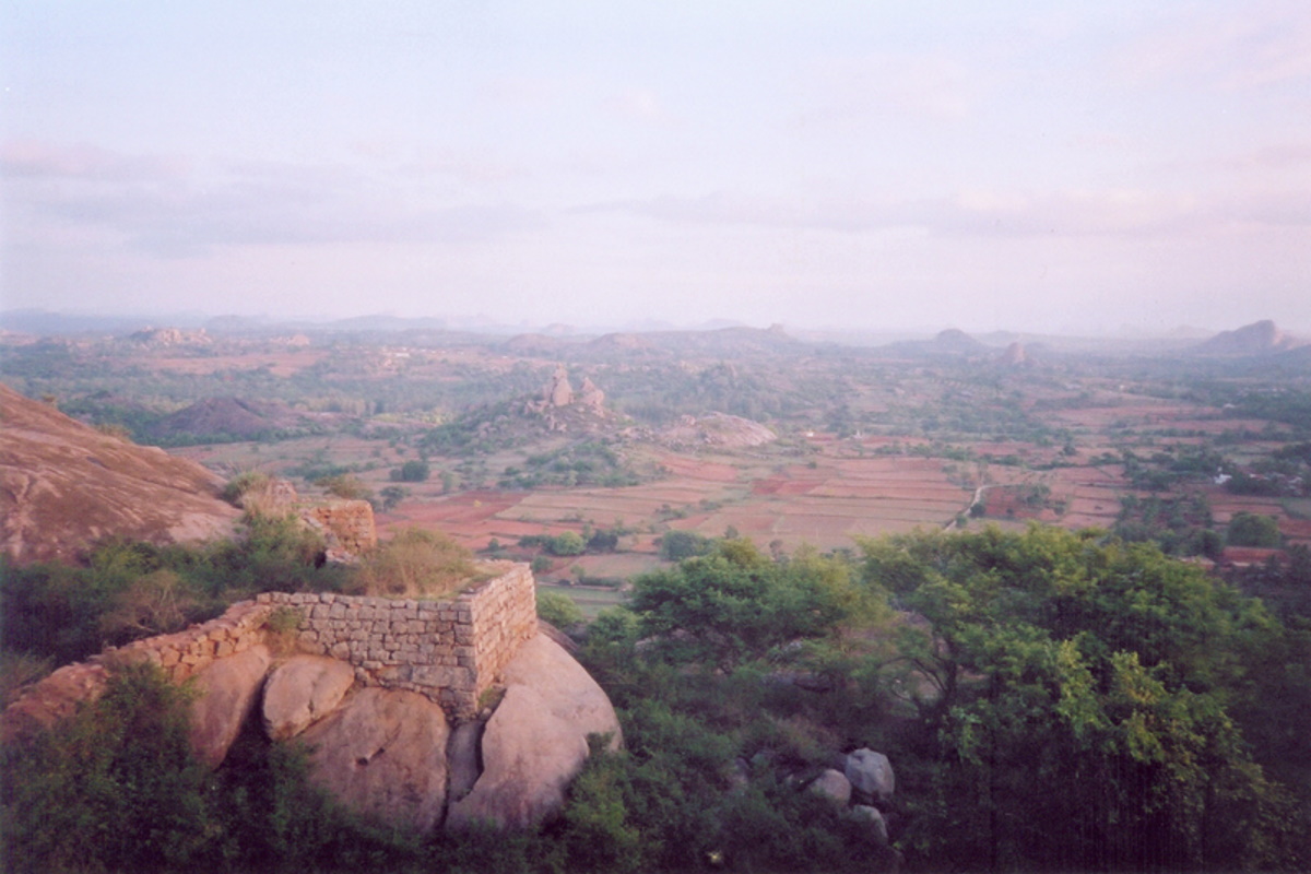
That's Savandurga hill in the background as seen from the plateau. In the midground is a line of rampart wall with bastions at regular intervals. The wall running from east to west is about 950 meters. Close to the eastern end of the wall is a gateway - marked B in the screenshot. On the right is a hillock with a walled enclosure.

This is the gateway in the wall. The fort builders have taken care not to expose the opening directly, a screen wall conceals the opening so that anyone entering has to slow down in the zigzag path. These walls seems to be built by the Palegar rulers, probably during Kempe Gowda's time. The condition of the walls are good.

Close to the gateway is a natural pond - marked as C on the screenshot. Rainwater from the hillock collects here. The rampart wall continues up the slope.

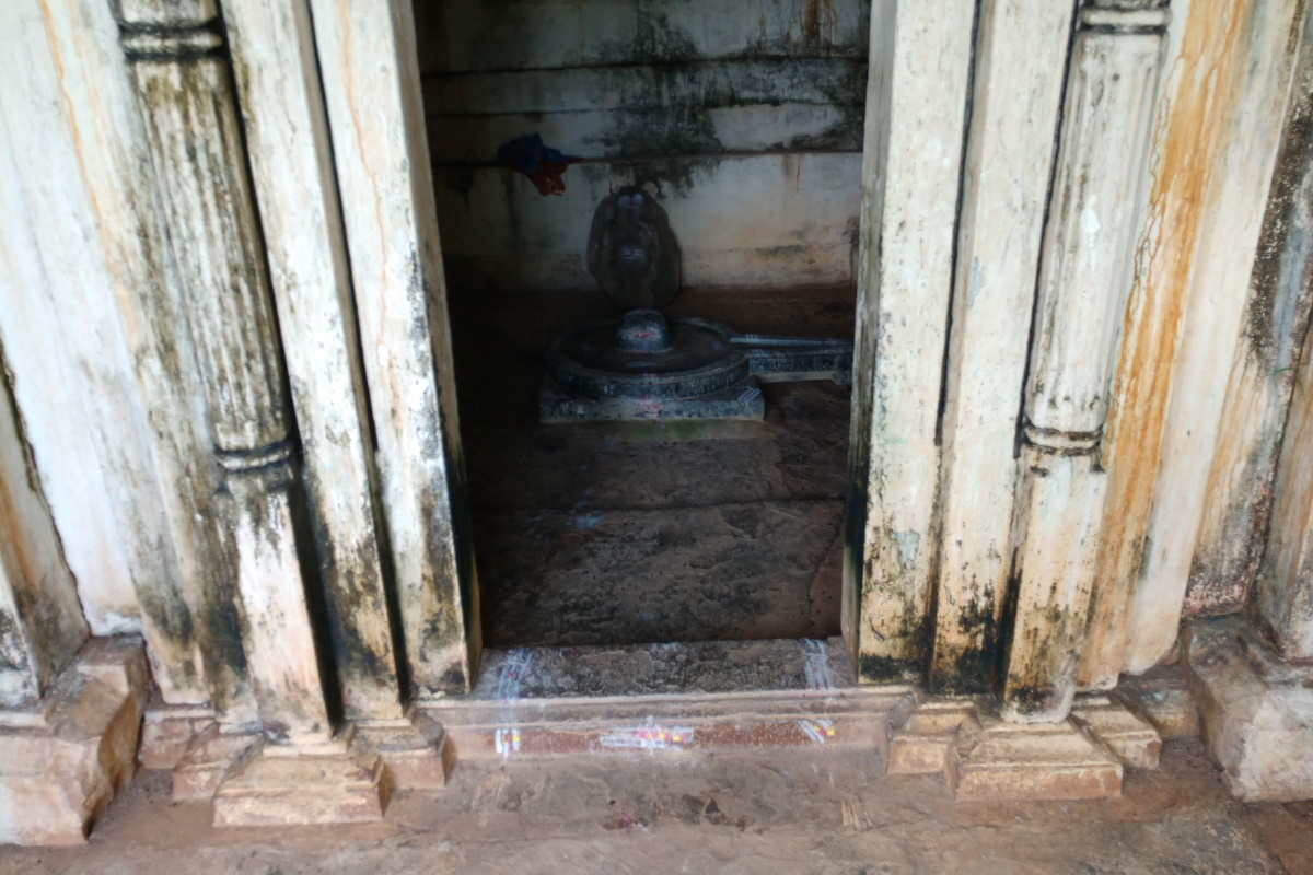
From the gateway, half a kilometer towards the left the temple can be seen - marked as G. As you see the temple is situated close to the main hill of Savandurga.

The temple is simple, has one Shikhara over its sanctum. The Shikhara is a brick & mortar creation. Going by the design of the Shikhara, it seems like Vijayanagara architecture. Since the Palegars were vassals of Vijayanagara kings, the same architecture was followed by them. In the early 2000s I had a aim-n-shoot Yashica. Every roll had 36 shots, so photography was rationed. I don't think I shot a closeup of the full temple.

This is Savandurga's Biligudda i.e. the white hill. The other peak which is called Karigudda i.e. black hill is concealed in this view.

This is the view of the hillock from the valley in front of the temple. Atop the hillock is the walled enclosure with four bastions and one entrance.

This is the north-western bastion. The walls are approximately 20' high. This enclosure is approximately 50 meters wide and 125 meters long. Within the enclosure is plain ground. Probably this was the arms and food grains depot.

Close to the enclosure entrance is this magnificent sculpture of a balustrade. Balustrades are fixed on either sides of steps of a temple or a mantapa. Looks like the construction work remained incomplete for some reason.

Close by was a broken piece of another balustrade. While the broken balustrade's surface is almost clear, the intact one is coated with a yellow layer - even though they are lying a few meters from each other.

Rajesh attempts to climb the wall. I think this is the south-eastern corner of the enclosure. I'm not sure if that's a niche or a escape passage.

This is not the wall of the enclosure but the kilometer long wall. According to local stories, this area was covered in a thick forest of bamboo. So this fort had a natural defense system in place.

Next to the enclosure is this natural pond (marked as F in the screenshot) measuring 90m x 14m at its longest and widest points. The pond seems to be 10' at its deepest point. We found clumps of elephant dung. Going by the dryness, it must be several weeks old. A caution if one is planning to camp here in the nights. Water ponds are normally visited by wild animals in the night, may not be a good idea to close to them.

The pond close to the gateway.... as seen from a bastion in the wall on the hillock. The wall is built on a slope which has quite a gradient. Also, notice the wall design, the lower half is dressed stones upon which sits a rammed earth wall. This type of walls can be seen at Chitradurga fort and many other forts.

The wall standing on the slope for at least four and half centuries. As far as I know, the rammed earth is cast on top of the stone wall using centering and scaffolding. Looking at this wall, I wonder how the engineers fixed the centering sheets. Truly amazing creation.

Another view of the wall and a bastion. I wish the bastion was free from vegetation, it would've been interesting to see the base of those walls.

The beautiful profile of Savandurga hill... five peaks. On the second peak from the right, is the Basava Mantapa. Inside the four pillared shelter is a statue of Nandi looking towards south. Our plan is to reach that Mantapa in the morning.

On the eastern side of the enclosure is a bastion positioned on the edge of a rock formation. Those days we had no Google Maps, so we didn't know the extent of the ruins without a guide's help. Having explored the area in Google Maps, I know how much is yet to be seen. Hopefully I'll go to Savandurga one more time just to explore the lower hills. 

The day was drawing towards its end. Sunsets are lovely here... viewing them from high ground and through clear air.

Rajesh and I went to Veerabhadra Swamy Devastana. The priest's house was in the temple's premises. He was kind enough to provide us food and shelter for the night. We woke up early and climbed the hill in cool weather. As always it was an awesome experience.

Here's a post dedicated to an overnight stay atop- Savandurga - overnight stay five.
.........

Oct 13, 2021

Savandurga

This image was shot sometime 1995 during my first solo trip to Savandurga. This view was seen from a spot a few kilometers away from Dodda Alada Mara (Big Banyan Tree), on the way to Manchenbele Dam. It was dry season, probably November or December.

.........

Oct 9, 2021

Uttarakumara Gudi, Tambur

This article is continuation of the previous article on Tambur Kere.

The main temple of Tambur village is Basavanna Gudi. The temple's chief deity is Shivalinga however due to the large Nandi idol the temple is known as Basavanna Devara Gudi. Then there are smaller temples who's history has been lost due to unthoughtful changes to the temple structures. The other historic temple of the village is on a mound on the northern outskirts. The temple is not really visible from the road because of the steepness of the mound. A few seconds ascent and the temple comes into view. The temple is small and taken over by vegetation. Villagers remove the overgrowth once the rains subside.

At the first glance, the temple looks like an ancient Greek structure. Probably because of the hidden Shikhara and side walls, the dominating pair of slim pillars create that effect. Anyway, the temple is compact, it has two sections- Ardhamantapa and Garbhagudi.

This is the rear of the temple. The walls are plain but the stepped Shikhara is slightly decorated. In fact there are many temple at Badami and Hampi with this type of Shikhara.

Here's a clearer view of the temple I found on Google Maps uploaded by a user named Shivakumar B. I couldn't find anyway to contact him hence took the liberty to post the image with due credit. The temple looks larger in this picture than in my photos. The architecture seems Chalukyan. It could be built around the same time as Basavanna Deva Gudi. 

Next to the temple entrance is this broken sculpture. The incomplete idol seems to be of a female character, its face has a peaceful expression. 

This is the Garbhagudi door frame work which consists of a pair of superbly sculpted columns, a Torana and door frame. Villagers have painted it lime trying to make it look nice but they don't realize that lime eats into the stone and weakens it eventually. Had the pillars been left alone, the details would be clearer. Now their real beauty is hidden.

The midsection i.e. the ribbed section of the pillar is a great piece of work. The base of the pillars is a standard design in Chalukyan temples. 

The temple's deity is Shivalinga. The other idol behind the deity is Ganesha. The Garbhagudi floor was littered with bat droppings. I feel weekly rituals is the norm here... probably every Monday, the temple floor is swept and washed before pooje is performed. Coming to the shrine's name, I'm wondering why its called Uttarakumara Gudi. To my knowledge, Uttarakumara is a boastful and cowardly prince in Mahabharatha. I'm not sure if this shrine has any connection to him.

This is the Garbhagudi ceiling. This too is a standard design in Chalukyan temples.

A view from inside the Ardhamantapa. Paddy and sugarcane fields as far as the eyes can see. The pillars are well made. Ancient builders never compromised on the quality irrespective of the temple size.

Full height pictures of the pillars. Besides the slim pillars, there are two stout rectangular section pillars supporting the walls and beams. 

The Ardhamantapa ceiling was low. A foot long nest of some insect... may be a wasp hive.

A cattle herd moving around asked me to check out another Shivalinga kept in the open but surrounded by low walls. The pedestal was superbly done... sharp edges and right angle corners. Even the Shivalinga was well sculpted. Even the cattle herd had no idea why the idol was in the open.

I thank the man and leave. This is the view of the path from the road to the temple. This is just to give an idea of the surroundings.

The heat was really get on now. Even a few minutes in sunlight was uncomfortable. I quickly get back into the car and start driving with all glasses down.

I think there are other less visited ancient temples in Dharwad district yet to be discovered. 
.........

Oct 2, 2021

Tambur Kere

This article is continuation of the previous post Tambur Basavanna Devastana.

Tambur Kere is about a kilometer from the village towards the south. This manmade waterbody can be called as a large pond. When its filled to the brim, the pond is 550m at its longest and 250m at its widest. The pond is fed by streams flowing down from the surrounding jungle and agricultural fields. A small check dam is where the pond overflows. During our visit the pond had overflowed a few weeks back. A stream of water had caused considerable erosion in its path. The pond seems to be shallow... probably due to accumulation of dirt on the bed. Anyway, the pond is a pretty sight.

The day was warm, sultry and humid, clouds were building up rapidly.

Along the northern shore of the pond are sugarcane fields. This is the tallest sugarcane I'd even seen. They were almost 15 feet high. Surely the farmers have worked hard, yet the credit for such a crop has to be attributed to rainwater. Along the southern shore is forest department plantation. The villagers had cautioned against entering the jungle. We had no intention of doing so, we weren't prepared for a jungle trek.

With the sultry weather, everything was still, the pond surface looked like a mirror. If not for the projecting grass shoots, it would've been a perfect mirror.

That shore along the jungle could be frequented by wildlife during nights. Wild animals like deer, bear, leopard, porcupine, fox, wild boar, and even elephants live in these jungles. Peacocks are abundant here, one can hear them cry early mornings.

The pond has hundreds of lotus plants. The cluster of lotus plants almost runs from shore to shore. This is a sight I don't remember seeing before. Every leaf had puddles of rainwater, probably it had rained in the night, The puddles looked like gems scattered over the leaves.

Normally lotus leaves are flat. Here we have a curled up leaf. I guess this leaf is drying, probably at the end of its life. An important characteristic of these leaves is they are waterproof. The puddles are really are adhering to the leaves, rather they are floating on them. These puddles must be feeling "so near yet so far." 

In this picture, besides the partly curled up leaf, there's a fully curled up one, as if its been rolled up from opposite sides. I guess that leaf's life is over.

The brown patch at the pond center are water plants or remains of water plants. I wonder if its remnants of lotus plants. I guess the pond has been leased to some fishing contractor.

A fallen tree carries on as it is. By the looks of the tree, it must be like for a few years.

Captured by Pushpa while I shot water lily leaves.

The fallen tree probably stood at the edge of the pond. A gust of wind must've pushed it into the lake. The path to the road passes over this mound.

As we walked back to the car, our eyes caught a few striped stones, or rather layered stones. The black layers seems to be rich in iron.

One last look at the southern shore. The tall tree is the landmark here.

The path over the mound is used by people and cattle. On the way a cow and its calf froze in their tracks. We were strangers and they were skeptical. As we neared them, they didn't have a choice but to move ahead and away from us :)

This is the view of the pond waters from the check dam. The dam is barely 15 feet long and 2 feet wide at the crest. Village women come here to wash clothes. Four of them were here chatting happily and working... typical village life.

Back to the road. By now the air was warm and thick with humidity. See the dark clouds forming. Chances of afternoon rain was high. We just wanted to get into the car, start driving and feel the cool air.

We passed through the village and heading out. On the outskirts, a lad on a bike waved at us to stop. When he came to know about my blog, he asked me to write about Tambur Basavanna temple. Then he told me about another ancient temple close to the last house of the village on the road. Yes, that would be interesting. Our next stop was half a minute away- Uttarakumara Gudi.
.........