


.........
Jan 26, 2023. It was a hectic day starting with a drive from Bengaluru to Tumkur. Met a friend at Tumkur, then I drove to Kadaba village to see the historic Kailasnatha Devastana. From Kadaba I went to Nagalapura to see two Hoysala temples- 1. Kedareshwara and 2. Chennakeshava. By the time I was done with Nagalpura temples, it was 4-45. The day was almost over and I had three places remaining on my list- Araluguppe, Turuvekere and Vignasante. I decided to call it a day and thought of spending the night at Tiptur. On reaching Turuvekere, I called Satish, my friend from Tiptur, to know a decent hotel for an overnight stay. As we spoke, Satish suggested me to check out Mallaghatta lake, about 7 km from Turuvekere. Satish said it was a huge lake with beautiful sights. I was fine with the idea and headed towards Mallaghatta Kere. Once the lake came into view, the road runs along its bank for couple of kilometers. I kept driving until I reached its check dam where a few cars were parked. I guessed that was a view point. A stone's throw from the check dam is Gangadareshwara Gudi. I parked my car close to the temple and stepped out to relish this marvelous sight. As Satish said, the lake is huge, its waters stretch as far as the horizon.

This is Gangadareshwara Gudi. Its gates were locked but the deity could be seen from outside.
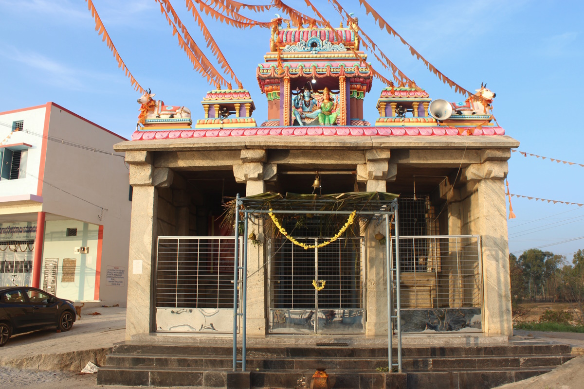
Another view of the temple.

This is the road bridge across the overflow stream. The lone date palm is an iconic landmark here. The stream makes its way through the mass of granite rocks towards the eucalyptus plantation and flows towards Turuvekere.

This is the picture of Mallaghatta Kere check dam. The lake was overflowing for several months and had stopped just a few days before my visit. Tumkur district has a huge number of waterbodies, each of them a part of a huge network which feed river Hemavati. Some of the major lakes of this region are Hindiskere, Nonavinakere, Mallaghatta Kere, Turuvekere, Nagalapura Kere, Myrasandra Kere, Sulekere, Kadaba Kere, Heraganahalli Kere and Dasanakere. As I know Nonavinakere overflow feeds Mallaghatta Kere which in turn feeds Turuvekere and so on. This network of capturing rainwater was created as early as IX Century and maintained by successive rulers. Thanks to the futuristic planning of our ancestors, today we are still reaping the benefits of their efforts.

While I checked the surroundings, Sun had moved closer to the horizon. The still waters of the lake was almost mirror like.

The colors changed as it got dimmer.

Another day comes to an end.

The time spent here was really worth. I washed my feet, hands and face in the lake waters, it was refreshing, and I was ready for the short drive to Tiptur.
This article is continuation of the previous post Tambur Basavanna Devastana.
Tambur Kere is about a kilometer from the village towards the south. This manmade waterbody can be called as a large pond. When its filled to the brim, the pond is 550m at its longest and 250m at its widest. The pond is fed by streams flowing down from the surrounding jungle and agricultural fields. A small check dam is where the pond overflows. During our visit the pond had overflowed a few weeks back. A stream of water had caused considerable erosion in its path. The pond seems to be shallow... probably due to accumulation of dirt on the bed. Anyway, the pond is a pretty sight.

The day was warm, sultry and humid, clouds were building up rapidly.

Along the northern shore of the pond are sugarcane fields. This is the tallest sugarcane I'd even seen. They were almost 15 feet high. Surely the farmers have worked hard, yet the credit for such a crop has to be attributed to rainwater. Along the southern shore is forest department plantation. The villagers had cautioned against entering the jungle. We had no intention of doing so, we weren't prepared for a jungle trek.

With the sultry weather, everything was still, the pond surface looked like a mirror. If not for the projecting grass shoots, it would've been a perfect mirror.

That shore along the jungle could be frequented by wildlife during nights. Wild animals like deer, bear, leopard, porcupine, fox, wild boar, and even elephants live in these jungles. Peacocks are abundant here, one can hear them cry early mornings.

The pond has hundreds of lotus plants. The cluster of lotus plants almost runs from shore to shore. This is a sight I don't remember seeing before. Every leaf had puddles of rainwater, probably it had rained in the night, The puddles looked like gems scattered over the leaves.

Normally lotus leaves are flat. Here we have a curled up leaf. I guess this leaf is drying, probably at the end of its life. An important characteristic of these leaves is they are waterproof. The puddles are really are adhering to the leaves, rather they are floating on them. These puddles must be feeling "so near yet so far."

In this picture, besides the partly curled up leaf, there's a fully curled up one, as if its been rolled up from opposite sides. I guess that leaf's life is over.

The brown patch at the pond center are water plants or remains of water plants. I wonder if its remnants of lotus plants. I guess the pond has been leased to some fishing contractor.

A fallen tree carries on as it is. By the looks of the tree, it must be like for a few years.

Captured by Pushpa while I shot water lily leaves.

The fallen tree probably stood at the edge of the pond. A gust of wind must've pushed it into the lake. The path to the road passes over this mound.

As we walked back to the car, our eyes caught a few striped stones, or rather layered stones. The black layers seems to be rich in iron.

One last look at the southern shore. The tall tree is the landmark here.

The path over the mound is used by people and cattle. On the way a cow and its calf froze in their tracks. We were strangers and they were skeptical. As we neared them, they didn't have a choice but to move ahead and away from us :)

This is the view of the pond waters from the check dam. The dam is barely 15 feet long and 2 feet wide at the crest. Village women come here to wash clothes. Four of them were here chatting happily and working... typical village life.

Back to the road. By now the air was warm and thick with humidity. See the dark clouds forming. Chances of afternoon rain was high. We just wanted to get into the car, start driving and feel the cool air.

We passed through the village and heading out. On the outskirts, a lad on a bike waved at us to stop. When he came to know about my blog, he asked me to write about Tambur Basavanna temple. Then he told me about another ancient temple close to the last house of the village on the road. Yes, that would be interesting. Our next stop was half a minute away- Uttarakumara Gudi.
.........Mandaragiri is one of the monoliths dotting the region between Tumkur and Dobbaspete. The hill, though not a very tall one, is visible from Bengaluru-Tumkur highway. I've seen the hill almost every journey on this road. Its visible even from the railway line. Yet, I hadn't visited it.
June 22, 2021
My journey from Dharwad started early. Destination was Bengaluru. First stop was at Revana Siddeshwara Devastana at Dodda Bathi hill. The second stop was to see the Pillow Lava rocks at the geological heritage site of Maradihalli between Chitradurga and Hiriyur. Few minutes after crossing Sira, I called a friend at Tumkur but there was no response. I wanted to pay a surprise visit but after trying to reach the friend in other ways did not work. As I approached Tumkur, I gave up on the plan and decided to go to Bangalore. After Kyatsandra, on the left hand side, Mandaragiri hill comes into view... let me see the hill today! Seconds later the arch of Mandaragiri was visible, that was the spot to leave the highway to go to the hill. The road cuts across a railway line, goes through a village, winds a bit for a kilometer and then goes through open land.

With hardly any people around, the place had a peaceful feeling. There were some huge boulders standing on open land, and on the other side of the road was a group of small buildings. One of the buildings was unique, shaped like an inverted funnel. Decided to check that out later. Then there was a toll gate. The gatekeeper charged ₹40 to enter the premises. I find a spot to park my car and take a long look at the stairway. Its a short climb, may be 10 minutes to the top.

At present there were five other people climbing up. The slope is not steep, so the steps are low, easy to climb.

A few seconds break. The view is interesting.

As expected the climb lasted less than 10 minutes. However people who started climbing ahead of me were still halfway up. The horizon is ragged.. plenty of hills scattered on the plains. On the left hand side of the horizon is a well shaped peak... that's granite hill called Shivagange.

I wasn't carrying the DSLRs, here's a not so bad picture from my Moto Z. As you see Shivagange is shaped like a Shivalinga. The monolithic rock hill looks like a sleeping bull from the other side.

Back to Mandaragiri, atop the hill is a walled enclosure with four or five ancient shrines. The simple ancient shrine is now undergoing expansion. A concrete platform has been constructed which sits a circular platform. At the center of the circular platform a sculpture is taking shape.

I took a peek into the scaffolding, the sculpture seems to be a tree with lot of branches. Well, we'll have to wait until the scaffolding is removed to know what would be standing there.

This is the entrance to the enclosure. I'm guessing the shrines are accessible to Jains alone, for carrying out their rituals or to make offerings. The enclosure is quite secure with chain-link fence on top of the wall.. may be its needed since this site is remote.

A modern building stands at one corner of the enclosure. Probably its an office or a hall for pilgrims to rest. May be there's a kitchen as well. A footpath runs along the wall to the other side of the hill. Would be interesting since there's a lake behind the hill.

A little pond on the side, definitely an ancient one to harvest rainwater. Notice the boulder with tiger painting? In the background are hills with wounds caused by quarrying activities. Granite business seriously affects out landscape and environment as well. Major changes in the terrain disrupts rainwater flow, probably cutting off supplies to ponds or lakes or even rivers.

This is the northern side of the enclosure. Probably there was another gate here which is being renovated with a Gopura. Since most temples face either north or east, this could be the main entrance of the enclosure.

Close to the pond is another boulder which seems like a teardrop from this side. It has a flat face on the left hand side, very convenient to paint pictures on it.

The boulder's other end. From here it looks like a skewed cone.

A finely sculpted pillar caught my attention. Its a very handsome piece of artwork. It could be a of some incomplete structure or it could be simple discarded for some reason. In the background, is a boulder, a mantapa, a rocky mound and waters of a lovely lake... a very interesting scene.

I turn a bit keeping the pillar in view. There's another on the right. Two mounds forming a cleft between them.. this place would be magical during rains, sunrises, sunsets and full moon nights.

I turn some more. The base of the pillar is designed to fit into a socket... ancient self aligning and locking designs. This could be made anytime from Hoysala's time to post Vijayanagara times. On the ground are sings of light quarrying activity, probably to reduce the slope of the hill to make it convenient for pilgrims to climb, especially in wet conditions.

Last of the series is a view of the enclosure and the boulder. Its because of our ancient shrines hills have survived modern times. Any hill without a shrine is an easy target for mining or quarry companies. Its my thought that many of our superstitions were made to protect Nature's creations like trees, or lakes or hills or even rivers and seas. However, in the name of science, every superstition was made to foolish or evil. One need to really think deeper while dealing with matters connected to ancient people.

This is the scene I loved most. A rainwater harvesting pond, the hills, Mydala Kere waters, and the jagged horizon formed by the hills of Devarayana Durga. I stood here for a minute captivated by the scene. An ideal place for a spiritual center.

I'll continue the article in Mandaaragiri part-2 where we see few more scene of the lake, a sculpture on a boulder, and a mantapa.
.........
February 2010
This particular trip was literally planned over months with a trial of discussions. Finally it was a seven member group- Yasmeen, Vidya, Shweta, Shilpa, Marina, Arshiya and me. We hired a Chevrolet Tavera for the trip. My first ride in Tavera. I just did not like the vehicle. Journey was not really comfortable with it's crammed seating and rolling ride. I'll never again hire this vehicle. Not a good start?
It was still dark when we picked Marina from Gokul Road, Hubli. We were moving towards Yellapur, all excited to see Lalguli Waterfalls, especially Vidya. We were glad to have left early but... few kilometers after Kalghatgi we saw a line of ore laden trucks parked on our left. It was light now. We seemed to be driving past an endless line of trucks. After about 3 kilometers the left lane was blocked. We drove on the right lane past between two parallel lines of trucks and finally we came to an halt. We were surrounded by trucks. We heard people saying they were stuck since 3AM and someone gave an expert opinion that this mess would take another 3 hours to clear.
I was praying silently, wishing to slip out of quickly. Yes, prayers answered. We drove past the damned ore transshipment center, the sole reason behind this jam. It seems this is a daily affair on this highway. Trucks from Bellary reach here early mornings queuing up to unload ore. Unloading would start at day-break. More and more trucks keep joining the line stretching up to 10 kilometers at times. This means mining businesses use national highways for their own needs.
Finally we were moving as we should be normally moving on a highway. About 10kms before Yellapur, we turned right- road to Haliyal. We asked for directions to Lalguli falls and we overshot the left turn by 6kms. However the road was good, running through thick jungle. We could see plenty of wild fowls. Anyway took a U-turn at a Forest Check Post. The road to Lalguli falls was narrow and in bad shape. We drove deeper into the jungle. On the way we stopped people and asked about water at the falls. No. This is the wrong time of the year. Anyway, we were hungry we stopped to have idlis cooked in jack fruit leaves.

Same info at Lalguli village. One of the locals described it would be a long trek to see nothing. We decided not to go.
Our next stop was Veena's place- Idagundi. The night before was Maha-Shivaratri and Veena was awake through the night. Veena looked tired but still she mustered energy to give us a tour of their family arecanut plantation. Veena had experimented with Vanilla plants and she explained the process of pollination. Back in the house Veena's mother had made avalakki and paanka.
 That's Ramlingeswara Gudi which is quite popular in Yellapur area. Veena's cousin Mahesh accompanied me to the temple. He told me stories connected with this temple. One day I need to sit with him and listen. I remember during my last visit, I heard the Kannada word for wedding reception- mitrabhojana.
Our next destination- Kavdikere. We asked Veena to join us but she declined.

We trekked the trial along the lake's 2.5km perimeter. We stopped by to eat water melon. It was delicious.

Naaz could identify an insect eating plant on the moist lake bed. It was pretty warm even though we were walking in partial shade. By the time we came back to the Tavera the gang was exhausted. I wonder how many cursed my for coming up with this idea. No appetite for lunch but we did have. We fed rice and kalinapalya to few cows. We moved on to Magod waterfall.


We rested a while here. For few minutes I felt a peaceful feeling coming over me by watching the water cascading down the rocks and birds flying freely above this deep gorge. These birds seemed supremely confident.
Our final destination of our day- Jeukalgudda. We made tea. It turned out pretty good and refreshing after a tiring day. We could not see the sun set but we saw it fading into the mist on the horizon. End of the day.

Does the sky look honey colored?
Jenukal = Jenu + Kal ~ Honey + Stone

We chatted most of the way back. I was busy watching the road and our cab driver. We dropped off Marina and we were back in Dharwad by 9-15PM. The outing was not really an ideal one but the moments would remain in our memories.
.........


