Jun 26, 2011

Aihole Fort and Meguthi Temple

My first visit to Aihole and Meguti Temple was February 1996, during the 13-day tour around Karnataka on Hero Honda Splendor. I had forgotten about the fort completely. That's our guide whose name I cannot recall and me.


It's only recently I rediscovered Aihole Fort.

April 3, 2011. We arrive at Aihole around noon and spend time at Durga temple, Ravna Phadi temple, two other temple complexes, have lunch at a local Khanavali and come to the fort.

View of the hill, two-story Buddhist temple, fort and Meguti temple from Ravanaphadi rock cut temple.


At the foot of the hill.


Half way up the hill.


I pass by the two-story Buddhist temple.


Meguti Temple as seen from the fort gateway.


Google Map screen shot of Aihole Fort.


A - Stairway
B - Two-story Buddhist temple
C - Fort gateway
D - Meguti temple
E - Desai Vade

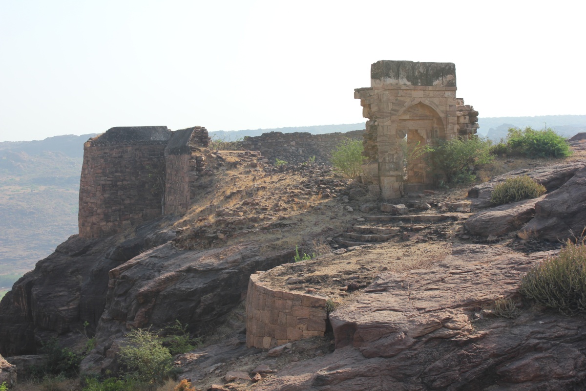
The fort walls are restored recently, stones packed with mud. The wall is not very high, at places its barely 10 feet. I went walking on the wall, clock-wise. I'm standing on South-East bastion looking towards the fort gateway.


and to left, the South-West bastion. The water-body in the background must be Malaprabha river.


Closer look at the bastion. The job seems well done... on the surface. But the walls are pretty fragile. I wonder if the walls can withstand a good rainy season. The mud might run off with water under a heavy shower.


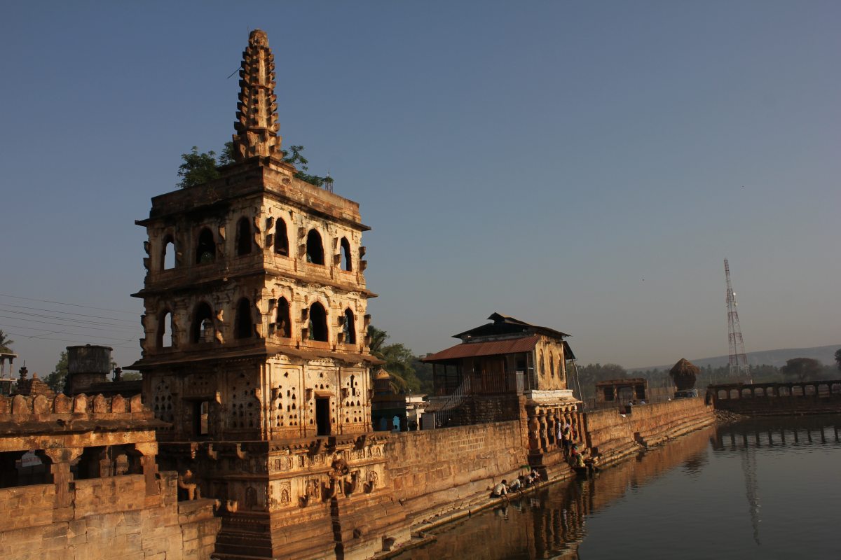
Rear side of Meguti temple. What a handsome structure it is!


The South-West bastion as seen from middle of the Western wall.


The North-West bastion.


As seen from the North-West corner.


The structure looks solid and neat. The architecture is purely functional.


Quoting two lines from Wikipedia- The temple which was possibly never completed gives important evidence of early development in dravidian style of architecture. The dated inscription found on the outer wall of the temple records the construction of the temple by Ravikeerthi, a scholar in the court of emperor Pulakeshi II.

The half-standing tower in the middle and the sloping roof caught my attention. The place has a different look... it's a Desai vaade. Later in the day we actually visited the vaade. The owners live in some city, the care-takers showed us around. The place was being renovated.


Ancient sculptures of two couples.


Is that Buddha in meditating position?


On the way down, I stop by the two-story Buddhist temple. The first floor had a rock-cut chamber, probably used for meditating.


Simply beautiful! I'm awe struck at the simple styling.


A signature in stone.


Praveen had come down quite some time back and befriended two brothers, locals living just where the steps start. They were chatting about agriculture and prices of jowar. One of the brothers has settled in Udupi and was on a vacation. The little girl in the middle is the Udupi brother's grand-daughter and the other two girls are her Aihole cousins.


Aihole Fort Coordinates: 16°1'2"N 75°53'2"E

.........

Jun 19, 2011

Naganatha Kolla

April 3, 2011

One of the restored temples in Badami region which most tourists do not notice or do not bother to visit. The temple is off Banashankari-Shivayogi Mandir road, its one kilometer inside a shallow valley in between ridges. The location is little secluded, that made me wonder; why such a location?

The approach road was under repairs, we (Praveen and Suresh mama was my company) had to park our cab pretty close to the main road and walk.

We were the only people here. First thoughts on seeing the temple: Looks quite simple and plain. Why did we bother to walk one kilometer on pebble scattered dirt path under the blazing Sun. Anyway, we are here, let's check it out.

A small board describes the temple..

Basavanna caught my attention. A good piece of work.

The interior is a contrast of the exterior. Columns and ceiling are packed with art. I just snapped a couple of images. Nagadeva just above Basavanna.

Lord Shiva & Parvati riding Nandi.

Lord Brahma on Lotus.

No idea who these characters are riding a ram ...it looks more like four men have floored the animal. The ram's horn stands out in the image.

Cannot identify these characters riding a leaping horse. Saddles were used back then.

The temple floor was littered with bat droppings and air was not very healthy. I decided to go out and check the exterior. Walls are plain but windows are decorated.

One round around the temple and back at the front, the figures on the columns caught my attention. Something different...

Couples in intimate positions.


Of six such couples, I found this most beautiful. The posture depicts love and closeness between them.

A closer look. Check out the curves, they look so natural. This is the most sexiest piece of stone-art I've ever seen. I was totally captivated by this image, spent a good ten minutes appreciating it.

Yes, the one kilometer walk on pebble scattered dirt path under the blazing Sun was worth the trouble. And the answer to the question why such a location: who ever got his temple made, wanted to keep it a secret ...not for everyone's eyes- that's my thought.

I'll make it a point to visit Naganatha temple again and spend time inside. I'm sure I missed lot of interesting art... we had to leave since the main topic for the day was Aihole.

The only video I shot here.


Naganatha temple Coordinates: 15°54'10"N 75°44'19"E

.........

Jun 12, 2011

Banashankari Temple Tank and Lamp-Tower

During my visit early 2000, the tank was dry, it's bed was in plain view. Many pilgrims would miss the customary bath. I guess North Karnataka was reeling under drought for the fourth year. The next visit, sometime 2009, the tank was full, a sight I enjoyed. I was here with Chetan and Dr.Kamat. We visited Banashakari Temple, had rotti & palya and moved on to Badami.

April 3, 2011.

This visit, Pushkarni was half full even during summer. On the left is the multi-level deepastamba, middle is the snana-ghatta ~ bathing place and to the right is Banashankari temple gateway.


The tank must be 80m x 80m. Three sides of the tank perimeter have stone shelters for pilgrims.


Long rows of sandstone pillars support thick slabs overhead. Built hundreds of years ago, thousand of travelers must have found this three-sided shelter a relaxing place.


The eastern perimeter. Every column, every beam in perfect alignment. Total quality control right from designing to execution.


Ports with steps to access water are provided at regular intervals. The distance between each bathing place is enough to give little privacy.


There's the imposing five story lamp-tower. Chetan and I had climbed up tower during my previous visit. The view from the top is little chaotic with modern construction around the temple, however the climb was adventurous, we got to see the inner beauty too. Every level has pockets (for oil) with little notches (for wicks). I wonder if they light up the tower. What a sight it would create after sunset, entire tower glowing with little lamps and the light reflecting in the water. I wish I could see it once.


As seen from street level. I marvel at the engineering precision and the artistic beauty in this structure. Its one great assembly of hundreds of stones sculpted to fit perfectly. And its been there standing for centuries. And the architecture; one can never get bored unlike modern day building designs.


We had step over the elephant's head to climb onto the first level. You can see two arms on either sides with pockets for oil & wick at the ends. The lamp on the right is damaged while the one on the left is intact.


Another lamp-tower, built on the wall around Shakhambari (another name of goddess Banashankari) temple.


Within the temple walls there are 3 or 4 smaller lamp-towers shaped like menhir. Over the last two years of travelling, during my visits to ancient temples in North Karnataka, I've seen 3 major designs in deepastambas: simple monolith design, tower with menhir at the top with a built-in stairway and the complex multi-level design. Banashankari temple boasts of all 3 types. The only other lamp-tower equal in height (or taller ) is the one at Mallya Temple on Bijapur-Gulburga Road.

The temple chariot stands idle through the year except for the annual fair.


Imagine the resources employed to carve, sculpt and move thousands of thousands of tonnes stones and build thousands of temples of matchless beauty. Temples, ponds, shelters are created for all to use, for the society, not for personal glory. Tombs and palaces of Muslim rulers are no doubt beautiful but they were made to glorify individuals. From what I've read, Muslim rulers have often employed prisoners and forced people into slavery to build their dream structures. Well, there are differences in cultures...

Do make it a point to visit Banashankari if & when you are at Badami. Its not just Badami Caves. Its not just Badami, Pattadkal and Aihole. It should be Banashankari, Badami, Mahakuta, Pattadkal and Aihole.

Banashankari Coordinates: 15°53'15"N 75°42'18"E

.........

Jun 5, 2011

Badami fort and Arali Theerta

Badami Fort is spread over the hills in two parts, North and South, with the Agasthya Teertha in between. I had explored the Northern fort two times, according to a source Tipu Sultan's treasury was housed here. I had seen Southern fort long time back... during my first visit, early 80s. I cannot remember much except climbing the crazily narrow, high and steep steps. During my second visit late 90s I was disappointed to see the doorway locked. Guides told that a tourist had a fatal accident on the steps. And I ended up seeing this view during four visits.


I was determined to go up and see the fort. There has to be another way, it's such a big hill. I checked Google Maps and found a way but decided to check with locals is if anyone could guide me up.

View of both Northern and Southern parts of Badami fort.


Closer look at North fort.


The South fort- my destination.


We had reached Badami Caves by 7-15. We inquired one of the locals about the way up and a guide. Fortunately the person was encouraging... said it's not difficult to reach up, you can go on your own but would be better to take someone who nows the way around. I opted for the latter option. Soon we were introduced to a lady who in turn found the guide- Avanesh. I was skeptical if I would get along with Avanesh, he had a frown and he had woken up after a late night celebrating India's victory in the World Cup Cricket. Never mind...

Avanesh lead and I followed... first couple minutes the path was filty. Then it was fine but I got stuck at a bend, a very tricky crossing. The part of the rock had neither proper foot hold nor hand hold. To add to my dilemma, rock was slippery and a fall will end 10 feet below on a bed of thorns- Peek-Jaali-Mullu. Actually this path is often used by locals regularly and Avanesh just went around the bend as though he walked on plain land. I made Avanesh demonstrate three times and I was successful the third time. I asked him if any more circus ahead. No. The path ahead was through a cleft in the rock hill, climb was steep, over mounds of stones, had to step carefully. We might have climbed less than 10 minutes, we reached the top and the fort was in view.


Masons who built forts like this one must have been real brave characters.


The first cave is right below this wall.


The lonely cannon. You can see it's nose from down below.


Way to the steps leading down to the caves. Note how steep and narrow the stairway is. I wanted to go closer but Peek-Jaali-Mullu blocked my path. In fact the entire fort is littered with thorns. If not for the villagers gathering them, the place would be out of bounds.


The walls are well preserved but nothing inside them is left standing. to the left you can ruins... of a small palace?


Looks like a doorway to a royal home.


This part of the fort is built on the edge of a sheer cliff, two or three bastions and walls.


We were done and ready to head down. I asked Avanesh if there's anything else to see. Do you want to see old images? Yes! I imagined seeing some pre-historic paintings. Again, Avanesh lead and I followed. The view from above was great. Sun was bright but the breeze cooled me. 500m further rocks had strange shapes like inverted ice-cream bowls.


During rainy season a stream would be flowing very close where we are now. The stream would dive down the hill and flow into Agastya Threertha. The place would be stunning during rainy season.


Probably the biggest ice-cream bowl.


We must have walked a kilometer to reach this little cave temple with a neat row of standing figures, an inscription in Devanagari script, a pond of it's own and a small room. I asked for the name, Avanesh told and I forgot to make a note of it... some Theertha. PS- this place is called Arali Theerta.


Part of the pond. Water was pretty clean but plastic a dozen bags floated in it.


Row of standing figures.


The largest figure. Is that Suryadeva? If you look below, it looks like a chariot drawn by seven horses.


The inscription in Devanagari.


The place is great, one can sit and mediate without anyone to disturb.

We had go back, Praveen and Suresh Mama did not want to join me in the climb, they were waiting at the car park. And we had to go to Aihole, I wanted to spend few hours this time... last time it was a rush, hardly saw anything. We head back towards the fort.

White building standing on the horizon are ruins of Badami Sugar Factory.


The climb down was not very difficult... only I had to choose firm stones to step on. Back at our tricky bend, I managed in one go. It was easier in this direction. I felt good. Finally I did see the fort. Thanks to Avanesh. We did get along fine :) There he is-


Later in the day, at Aihole, I learn about pre-historic rock paintings around Badami. I want to come back one day, get someone who's seen them and see them. Hope the day comes soon.

We head towards Banashankari.
.........