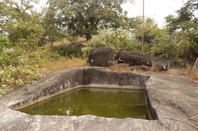
...continued from Fort Machigad part-1. In the first part of this article the parts covered are- reaching Machigad village, meeting my host Kalmeshwar, ascending Machigad hill, reaching the main entrance (Mahadwara), the remains of the inner doorway, saw Hanuman shrine and Mata Durga Mandir, spent a few minutes at the first Raamteerth view point and then came to this rock-cut water tank This water tank becomes a swimming pool for the village boys during summers. Of course the water tank is cleaned and maintained by village people so that they have water up here.
The vegetation is so thick that rampart walls are hidden at most places. This is one spot where a bit of a wall is exposed.

Now we are moving to the south western side of the fort. There's a large rock formation along the outer wall. Atop the rock formation is a turret. I think the turret (see inset) is the highest point of this fort. That's my host Kalmeshwar leading the way.

Kalmeshwar climbs up the boulders which is a natural defense line. This part can be very tricky during rains... very slippery surfaces.

To the left of where Kalmeshwar is standing is a gap in the rocks which has been blocked by a wall. The wall may look low from here but its high because its base is much below, out of sight from where I was.

This rock looks like a camel's hump. This spot is the second Raamteerth view point.

The hill seen in the background is Raamteerth hill. It gets its name because of the Ramlingeshwar Devastana there. The place is truly enchanting, especially early mornings and evenings.

Out there, there are three temples, two completed and one incomplete. Also, the temples stand right besides a water tank which is shaped like a large bowl in the rock, These temples were built during Goa Kadamba rule in the XII Century CE. I was there a few hours ago. To reach the temples, one needs to trek approximately 4 km through paddy fields and jungle.

Panning to the right, the neighboring hill comes into view. In fact, Machigad and Raamteerth are part of a group of hills which are closely connected to each other. There's a route from here to Raamteerth. People familiar with the route will be able to guide. May not be advisable for strangers to try any adventures here.

Below, there's another rock formation. It has a scary look. Below the huge rock is a cavern, a dark one. Kalmeshwar mentioned that cavern would be bears' home. Talking of wildlife, these hills are home to a variety of fauna like leopard, bears, porcupine, hare, wild cats, boars, snakes, wild fowls, peacocks, and many more. During my treks to Raamteerth I've seen long tail feather birds fly off suddenly. One of them had two-feet long white tail feathers.

We move on... our path went through a green tunnel. This would be a good place to rest but we kept moving.

Once out of the tunnel we come to this drop. This is one of the few open to sky spots on the outer wall. We had to climb down, to the ground next to the wall. The descent was about 15 feet but crazy. I stuffed my camera into the bag and then climbed down carefully.

Atop that rock formation is the turret, the highest point of Machigad. Had we come earlier, I might have tried climbing up there.

That boulder is like a water drop. A minute ago I were next to that boulder. Lot of crevices between these boulders. One needs to be really careful not to fall and get stuck between those rocks.

This wall is built of rough stones, probably left over pieces. The builders, very skilled hands, have done a superb job. This crude looking wall could be standing for the past 500 to 800 years, or more.

This space is a great sentry point for watching over the western plains & hills. Any movement could be spotted easily from up here. This view is in the general direction of Anandgada fort near Nanadgad which I has visited in Feb 2014. The similarities between Anandgad and Machigad are- both situated on hills and surrounded by jungle. Anandgada is harder to reach because the dirt road which passes over few hills is approximately 8 km. I think most forts in the western ghats are on hills & inside jungles.

This happens to be my favorite picture of all the pictures shot at Machigad. The jagged but elegant curve of the wall and then the curve of the stone. At the base of this wall is a hole. I think its has been provided to drain out rainwater.

We walk along the wall and descend a little again. There was a doorway like opening in the wall. I asked Kalmeshwar if it was a secret passage for escape. No, its just a little chamber. May be a rain shelter.

I was expecting we would continue along in the same direction but our path was blocked by thorny bushes. So we had to turn back, retrace our way until Raamteerth view point. We'll continue the exploration in the following post- Fort Machigad part-3.


No comments:
Post a Comment