October 5, 2013
After Belgaum and Kakati forts, Honnurgad was the third fort of the day. I still had three more on my itinerary- Vallabhgad, Samangad and Gokak forts.
 |
| Hunnur fort as seen from 1 km east |
The summit is a large bed of laterite rock. Fort builders have hacked out portions of the hill to create a vertical face and built a wall on the top. Builders have wisely utilized natural formations to their advantage.
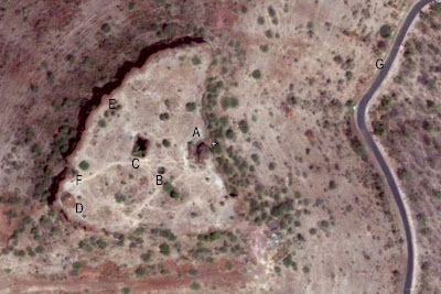
Here's the Google satellite view of the fort; its a triangle with curved sides. On the east is state highway number 134 and on the west is Hidkal reservoir (out of sight). Few spots of importance have been marked-
A - Mahadwara ~ main entrance
B - water tank
C - deep well
D - Nishan Burj ~ flag bastion
E - bastion
F - small gateway
I approach the fort from south and take the narrow footpath along the eastern edge hoping to find an entrance. A cleft in the rock wall with a curving path.. this should be the fort's entrance.
Yes, it is. This is typical Maratha architecture. This curved entrance will conceal the gateway completely when seen from a distance. Laterite hacked out to form this passage would have been used to build walls at the top.
Sentry chambers at the end of the passage.
This chamber is spacious enough for one man. In the wall is a nest for placing a lamp.
This is the eastern side of the fort. back then walls would be free from vegetation.
Part of the wall has collapsed. That's Hidkal reservoir in the background.
Lower part of the hill and the guest house.
Builder of this fort had planned storage/supply of water. There's one small water tank and a deep well, close to each other. This pit here is the well. It is roughly 30' x 30' and 60' deep. Sadly the well is dry and the bottom is littered with dry leaves. A flight of steps descends to half the depth.
This is the western wall, looking towards north..
and looking towards south. The mound on the edge is a bastion.
It's the only bastion and it has to be a flag bastion. In the foreground is a cleft.. this is a smaller entrance descending to the base of the fort wall. This passage is narrower and steeper than the main entrance.
I exit the fort through the smaller passage and climb down little to get this view of Honnurgad. It does look daunting to anyone planning to sneak into the fort.
I could not find any useful information about this fort. Hence what ever I've shared here is guess work based on experience.
Hunnurgad coordinates: 16°9'33"N 74°36'47"E
.........


No comments:
Post a Comment