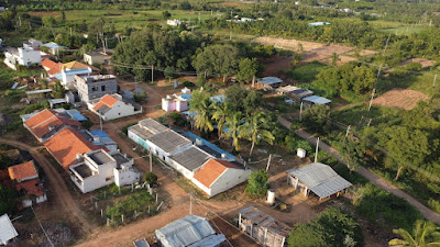
Sept 2024. Bhogasandra is another home. This visit I wanted to see the place like never before. That's where my DJI Mini 2 comes handy. I launched it from Sridhar's farm and sent it towards the village flying around 40 meters above ground level.
This is Bhogasandra's main junction. The straight line road goes towards Hagalavadi, the slightly curved road to the right leads to Sagasandra.
Pulling back a bit, the village Aralikatte comes into view. It's a Ficus with long curvy branches. Under it a lot of activity happens. The most important being peeling raw betel followed by cooking it. The tree looks pretty aged, hope it lives for many years to come. Talking about Aralikatte, it's an ancient custom which is fading now.
Pulling back again, more houses come into view. Most families of this village are related, it's almost like one big family.
Pulling back more. The mobile tower comes into view, covering the entire village, more or less.
Turning around 150° Bhogasandra Kere comes into view. It's a manmade pond. Part of the road connecting Bhogasandra to the neighboring village Bommarasanahalli runs parallel to the lake 's embankment. On the shore is Siddalingeshwara Devastana which was renovated about two years ago. The white line on the horizon is the aqueduct of Yetthinahole Drinking Water Project.
Now, DJI Mini 2 is hovering over Aralikatte.
Srishar's farm is in the greenery on the top-right of this picture.
The little house sits in Sridhar's farm. Notice the bamboo cluster?
Turning to the west. About a kilometer from here is forest land. In fact a small stream is a marker between farmlands and forest land.
DJI Mini 2 has a flight time of 12 to 13 minutes. So I had get it back and replace the drained battery with a fully charged one and start a new flight. This time I sent it beyond Bhogasandra towards our farmer friend Basavrju's plantation. At the middle of this picture next to the little pond is Basavaraju's betel plantation. I wanted to see a little further but the navigation screen froze with a black n white. The drone and remote controller had lost touch, no communication between the two. It was a tense few minutes when the drone homed in. The 'return to home' feature saved my Mini 2. Back at home I discussed this issue with brother and found the cause. Trees were a barrier between the drone and RC. Basically, Sridhar's farm is a good 10 to 15 meters below the village ground level. With the drone at 30 meters high and 500 meters away, the trees got into the way. While flying longer distances, it's better to maintain higher altitude. We err. Then we learn.
Here's the bamboo cluster. The shoots were swaying gently in the wind. What a beautiful sight that was.
That's Bhogasandra Kere.
Overhead shots of neighboring fields.
A geometric pattern of a well prepared field.
That's Basavraj on his Bajaj Pulsar. Raju and I had ridden that bike to the edge of the forest to see a shrine called Bhutappana Gudi.
This is Sridhar's farm. Another farmer, Siddaramanna is ploughing the aisles. This is one way to control weeds. Unfortunately, two sides of this plantation are vacant and neglected lands covered with all kinds of vegetation which is a big source of weed seeds. Those seeds get thrown into this farmland and thrive.
Raju noticed a peacock. I followed it from a safe height. Judging by it's movements, the peacock was confused... where's that buzzing sound coming from. Not once it looked up but kept moving around,
Sunset seen from an height of 25 meters above the farmhouse.
Lastly a view of us- Srishar, his son, son's friend and I.
Do check out our short visit to Bhutappana Gudi.
.........


