It was a long time wish to see Jaladurga. I'd been to Sindhudurg the island fort in Arabian Sea, but I also wanted to see a river island fort.
December 25, 2012
That's the bridge across the right fork of river Krishna as seen from Lingsugur taluq, Raichur district. This bridge is at the western tip of the island, close to Jaladurga village. The other bridge is downstream close to the eastern tip of the island. Tourists wanting to reach Jaladurga fort have to take this bridge. The dark mound on the horizon is Jaladurga fort ruins.
 Close up of fort ruins. The fort ruins can be seen from the base of the hill going right up to the summit. In fact this the highest point of the fort as well as the island.

Here's a rough schematic of the group of island formed by river Krishna. In fact river Krishna defines the district borders of Raichur and Yadir. Jaladurga occupies a the western tip of the island. Jala + Durga = water + fort. Perhaps we can call it Dweepadurga too. Dweepa + Durga = island + fort. About 4 kms downstream is another island with a small fort on it.
 At Jaladurga village we stopped to make inquiries. We got introduced to Amarappa Hadpad an elderly man who volunteered to show us the fort. The fort is about 1½ kms from the village, vehicles almost till the fort gate. We went through two gateways which means we passed two layers of fort walls. We parked the cab near Sangameshwara Matha, vehicles cant go any further. The monastery temple seemed ancient but we did not go in. We had to walk about ¼ km to reach this gateway.
 Gateway as seen from inside. That's Ravi looking at something to his right and in the passage is Mohan mama. Our guide Amarappa had gone ahead and waiting for us to catch up. Malatesh was lagging behind making videos.
 A short climb to the summit. There's a gateway at the end of the wall.
 We pass through the gateway to see another layer of wall!! To our right is a narrow passage.
 I guess the passage is made narrow for security purpose. I pas through it, turn right and climb the wall to get a good view of the ravine below.
 That's the left fork of river Krishna. Jaladurga falls in Yadgiri district. Mohan mama was really impressed by this place, he kept telling we must come back to see when the river is full. Yes, that would be a sight to see. I asked Amrappa is knew about the other island fort downstream. Yes, he knew but he did not know the name.
 The summit is not a small area but well utilized by the engineers. these are some of the ruins, perhaps officers' living quarters. End of the path is a small temple and the house of the temple priest. Just one little house at the top of the hill ..what a place to have a house :-)
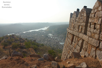
 We are looking towards the west, point where river Krishna splits. Upstream is Narayanpur dam. To the right is the only turret in this direction.
 That's our guide Amarappa Hadpad and Mohan mama.
 This turret sits on the edge of the hill overlooking the ravine. Folks mentioned that death sentences were carried out on here. We are standing over the rampart walls. To the right, the white structure concealed behind trees is the priest's house.
 This is the tomb of a Hindu saint, I cannot recall the name. Note the structure design is Islamic. In fact it looks like a mosque but it is a temple.
 Right next to the temple is a deep pit, its an open well, a dry one. Beyond the well are ruins.
 On the southern edge is this high rise structure. No doubt it is a tower built to provide unrestricted view of the fort and the island. From here I could see a number of streams joining river Krishna, of course most were dry. I really wish to come back here during August or September.
 View of the turret and the temple.
 Since the fort ruins are spread way down till the river, it would be a daunting task to explore the ruins fully, especially at the end of a hectic day. We trekked back to the cab. I was eager to look down into the ravine, I walked right to the edge of the hill. An amazing sight it was. See the water carved rocks in the riverbed. Those shafts are caused by whirlpools. Amarappa told us those shafts are huge, he gave us a measure in farmer's language. Those shafts can hold 200 quintal sacks or more. In layman terms those shafts might be 10' diameter x 20' deep. A little further downstream we could see three men bathing and washing clothes- so there's a way down. This reminds me of Mekedatu near Kanakapura.

 Just outside the gateway we stopped to explore the surroundings. Only Malatesh and I went exploring while Ravi got busy with his evening ritual of cleaning the front wind-shield followed by lighting incense. Mama and Amrappa were chatting away about agriculture and rains.
About 100m away from the road we found a gateway. There was a sculpture of Lord Hanuman leaning on a tree (see inset). One day I want to come back and spend a night on this island and explore the fort ruins top to bottom.
 Back at the cab, Ravi's evening ritual (symbolic cleaning of car & lighting incense) was in progress, I decided to walk towards the village and asked the gang to catch up. This is a part of the the outer walls with square bastions. Surely this fort was an important one. Some sources say that the fort was built by Adil Shahi sultans but I feel a fort did exist much before Adil Shahi rule. Next to the road, on the right hand side I saw a small structure (see inset) which is clearly a Islamic tomb. It might be a tomb of some officer serving Adil Shahi army.
 I kept walking and reached the village too but no sign of my gang. I tried calling them mobile signal was too weak. Well, I waited at the village chatting with folks. After 5 mins the cab arrives. Someone in the group had imagined I had gone exploring the ruins ..terrific! Anyway, had regrouped; we had tea at Amrappa's tea-shop and thanked him. We noted his postal address to send his pictures and said bye to Jaladurga.
Jaladurga fort coordinates: 16°15′09″N 76°25′10.3″E
.........
December 25, 2012
That's the bridge across the right fork of river Krishna as seen from Lingsugur taluq, Raichur district. This bridge is at the western tip of the island, close to Jaladurga village. The other bridge is downstream close to the eastern tip of the island. Tourists wanting to reach Jaladurga fort have to take this bridge. The dark mound on the horizon is Jaladurga fort ruins.


Here's a rough schematic of the group of island formed by river Krishna. In fact river Krishna defines the district borders of Raichur and Yadir. Jaladurga occupies a the western tip of the island. Jala + Durga = water + fort. Perhaps we can call it Dweepadurga too. Dweepa + Durga = island + fort. About 4 kms downstream is another island with a small fort on it.


View of the one of the gateways, as seen from inside.

About 100m away from the road we found a gateway. There was a sculpture of Lord Hanuman leaning on a tree (see inset). One day I want to come back and spend a night on this island and explore the fort ruins top to bottom.


Jaladurga fort coordinates: 16°15′09″N 76°25′10.3″E
.........


