Showing posts with label Chikballapur district. Show all posts

Jan 25, 2014

Fort Makalidurga

Makalidurga was on my mind for almost 3 years. The fort is situated north of Doddaballapur town, on the southern tip of Makali hills. Its a hill range 8 kilometers in length with multiple peaks. The hill is a mix of dirt and rocks, covered by woods. Bangalore - Hyderabad railway line runs parallel to the range.

October 16, 2013
Vivek and I left Bangalore early morning in a cab. Sky was heavy with dark clouds, between Yelahanka and Doddaballapur it rained, what started as a light shower became a heavy shower and it stopped abruptly. We went around Doddaballpur and took Hindupur road. Country side was green and fresh, it had rained the previous night. At Ghatisubramanya cross we stopped for breakfast, hot thatte idli and tea. As we drove further the sky was still cloudy and Makali hills came into view; it was covered in a thick veil of mist. We went past Makali Railway Station and located the dirt road leading to a Hanuman temple at the base of Makali hills, its situated very close to the railway tracks. For few seconds there was a gap in the misty screen and through it I could see the hill top.. towering high and seemed unreachable. With that glimpse of the hill top I knew the climb would not be an easy one.

We asked our cabby Siddaraju to wait for us, we should be back in 3 or 4 hours. It was barely 7-30 AM when we hit the trial, it was cold and damp. We found the temple and a small house, few dogs started barking. I was hoping to find someone so that we get proper directions but the only other creatures we saw were few chicken. Folks must still be sleeping.. who would want to leave their warm beds in such weather. We saw a path going up behind the temple, we followed it. A minute later we were at a fork.. right or left? We decided to go right, we followed the path which was getting steeper, wilder and wetter.. let's 'keep climbing' was our mantra for the time being.

Half an hour later, we were lost, no trial in view and mist would not go. Our trousers were wet with dew and to add to our misery it started raining! Luckily we had umbrellas, which prevented us from being completely drenched. The rain lasted some 10 minutes. The tall wet grass just got wetter and Vivek said he feels as though he's walking in water. We checked our position in Vivek's Samsung Galaxy; we were barely 100 meters north of the fort on the map but those 100 meters in reality would be some 300 meters steep climb. We took a real steep and narrow path hoping to reach the fort but we hit a hurdle. We could have climbed up the hurdle but climbing down that hurdle would be too risky. We trace back the way down and took another path, here we found a trial of different sort - fallen grass - it was like some creature has walked though the grass, moving uphill. Good we found something to follow :)

We tried to check our position but mobile signal was too weak. We kept following the trial of fallen grass.. another vertical hurdle in our path. This time we decided to go up, no matter what. The 15 feet was really tough we got over and voila there was a small wall. Ash, we are close. Through the mist we could see the outline of the walls.

Here grass was even more taller and denser. We had to feel every step before placing our foot. 10 minutes later the fort wall within reach. We did it! The climb was one helluva challenge. Vivek is looking for an entrance.. I was skeptical of finding a gateway here.

A short distance away, we found a crumbling wall, we clambered up the heap of stones and gained entry to the fort. This spot has been marked in line diagram of the fort's plan. This is the northern part of the fort.

Here's the rough plan of Makalidurga, no particular shape to it. There's an outer fort and an inner fort.

The base to fort route we took is not the regular one, it a round about route. On the way we definitely had cut across the regular path without even realizing it :( 3 hours climb, it was 10-30 AM.

We took left and followed the path on the wall. That's one of the bastions.

We reach a corner, northern most corner of Makalidurga. That domed structure (marked B in plan) must have been a sentry post, looks like it was built during Tipu Sultan's rule. We inspected the structure from outside, it was used as a camp few days ago, was littered with plastic bottles and paper. The wall turned right here.

Looks like raw material for this wall was sourced from this hill itself. Perhaps we walked through ancient quarries during the ascent.

Small gap in the misty screen gives a glimpse of foot hills. Looks like guards here had tough time carrying out their duty while mist and fog played around the hills.

I let Vivek lead the way to the fort's center. Those walls ahead are marked C in the plan. This fort is said to have history going back to the times of Vijayanagara. After the fall of Hampi, the fort would have come under other rulers before Tipu took control.


One of many ponds, water has turned green because of lack of maintenance.

the eastern wall

Kote Devastana ~ fort temple dedicated to Shiva. Architecture seems like Vijayanagara. The deities are damaged. Looks like folks from surrounding villages perform rituals during important festivals. Close to the temple is a 6' tall rough cut granite pillar.

We go exploring the southern tip of the fort but tall grass and hunger forces us to cut short the plans.

looking towards the temple

That bastion at the farthest point would be the southern most tip.

Past noon mist clears off. Our cab parked in shade partly visible. A small group of people alighted from the white WagonR.. looks like there are here to climb. Glimpse of the railway track at the bottom-right corner of the picture.

From the fort we looked down the slopes and planned a route, we decided to leave the well tread path at one point and turn right thinking that would be a short cut to the base... the railway crossing. However, I abandoned the plan and instead followed the well tread path.. looks like this is a cattle route. Vivek mentioned few times that we were heading opposite direction but I told him that we it might turn right somewhere..

The path descended to the plains but our attempt to search a short cut put is trouble, we ran into a area full of thorny bushes.. those curved needle like thorns tore into my skin through fabric too.. menacing little thorns they were. Sun was bright, we were warm, re ran out of water and our tummies were growling. Aagh our plight was pitiable. Luckily we found a man grazing cattle who told us we were on the other side of the hill. He pointed at a dirt path and asked us to follow it until we reached a village.. I think the village name was Basavanahalli. From there we'll have to go to Thondebhavi and hit Hindupur road. Now, the solution to our problem would be to call Siddaraju and ask him to drive down to Basavanahalli.

We hoped for some clean water as we walked and lo, we found this boy in his fields. He was a good host; let us rest in his hut's shade and offered water. Our friend Laxman, told us its not 'Makalidurga' as most people say, the correct spelling is 'Maaklidurga'. He then he took us to his fields where his three sisters were harvesting groundnuts. Laxman handed us a bunch each.. that would appease our tummies for time being. Laxman gave us directions, we thanked him and bid bye.

Fifteen minutes later we in the car driving back towards Doddaballpur via Thondebavi village. It was 2-30 PM. For lunch I asked Siddaraju to go find a mess where buses do not stop. On the state highway we stopped for a minute to capture this view of Maakli Gudda and Kote.

Maaklidurga perched atop Maakli Gudda

We found a mess on the bypass road next to a petrol/diesel bunk; it was 4 table eatery offering home made lunch. We relished the meal- chapati, palya, anna, saru, hapla and mosaru. Aah, felt great. Back in the cab, we sank into the seats while Siddaraju took us towards Devanahalli.

.........

Feb 27, 2013

Nandidurga ~ Nandi hills & fort

Nandi Hills was our favorite getaway during student days. It was easy to reach and climate at the hill top would be pleasant any time of the year. All visits to the hill are memorable but one visit's weather is unforgettable. it was with engineering college friends during a monsoon, the entire hill would be shrouded in mist from time to time as though it was playing hide n seek. The ambiance was just great! As popularity of Nandi Hills grew, the place got crowded; weekdays was fine but weekends the hill was more crowded than a vegetable market. Post engineering I visited Nandi Betta just two times and then avoided it altogether. Years later I decided to pay a visit just to see the fort walls.

August 14, 2012. I started the day with Varlakonda fort, then Sir M V memorial at Muddenhalli and Bhoga-Yoga Nandeshwara Devastana at Nandi Halli. This picture was taken while cruising towards Varlakonda on NH7 with Sudhakar at the wheel.

Tipu drop cliff as seen from a spot on ghat roads just before the valley between Brahmagiri and Nandi Betta.

Kite's eye view of Nandi Durga. Spots I visited are marked in numbers, see index below the image.

  1. Fort entrance - outer
  2. Fort entrance - inner
  3. Anthar Gange and Nursery
  4. Arkavati Ugamastana
  5. Tipu Drop
  6. Yoga Nandishwara Swamy Devastana
  7. Nallikai Basavanna
  8. Brahmasharam
  9. Palar Ugamastala
  10. Gateway
  11. Tipu Sultan Summer House
  12. Cubbon House

This is the main entry point to the Nandi Durga, this is the only approach for vehicles. The fort has three more entry points; one in the north-western corner while the other one is in the north-eastern corner and the fourth one must be a secret passage some where in the south-western part.

Nandi Durga's history goes back to Chola times, later it was part of Vijayanagara empire, then it was a strong hold for Tipu Sultan's army and finally in the hands of British government. Of course, Nandi Betta is now in Karnataka Rajya.

This is the inner gateway, its quite narrow, designed for security reasons.

I get off the cab and ask Sudhakar to take his cab right to top and wait for me there. I wanted to walk the entire perimeter of the fort. So I start my walk from this ancient stepped well. A signage close by calls this Antara Gange but I'm not sure of this is also called as Amrutha Sagar. This is a favorite spot for movie makers, especially song scenes. In and around this well are a bunch of red-face monkeys, at least one was a rouge type, he blocked our path with a nasty growl baring his fangs. Good I was not carrying any food in my backpack.

I walk on the tar road which runs along the fort wall for a short distance, there are couple of bastions from where you get a good view of the walls.

During my first visit I remember seeing the birthplace of river Arkavati. Back those days there was no board indicating the spot but there was water in the pit. Now there's a board - Arkavati Ugamastana -but the pit is dry :-( Besides Arkavati, Nandi Betta is birthplace for two more rivers Palar and Pennar.

Nandi Betta has two neighboring hills- Channagiri and Brahmagiri on its north and south respectively. This is Brahmagiri.

With an uphill trek through light woods I reach Tipu drop. A bunch of college boys were partying close by and another group were busy snapping away brave poses dangerously close to the edge. It is said that during Tipu rule, criminals' death sentences would be carried out here- they would be dropped off this sheer vertical cliff. this part of the hill doesn't need walls- the cliff is can't be scaled.

With Tipu drop behind me, I am looking at Yoganandeshwara temple's rear entrance. In the inset is the front gateway.

Now I'm very close to Mayura Hotel. A large platform has been installed here, you get a good view of the plains below. This is the T-junction; left to Muddenhalli, straight to Devanahalli and right to Doddaballapura.

To continue walking along the fort I had to climb down a bit. A strange sight greets you at the trial; a canon with its mouth buried in dirt.

That's Nallikyai Basavanna. Nallikayi is the Kannada word for gooseberry. As you see the mantapa is in ruins. I wish concerned government officials would repair this structure instead of spending on unwanted cement and steel structures on this hill.

This Basavaana is said to be 1300 years old i.e. of Chola period and this hill was known by the name Ananda Giri.  It is believed that this hill is named after this Nandi, the other name for Basavanna.
On this hill are several caves, this are few but sadly the caves seemed to be modified with stone and cement walls. This spot is called as Brahmashram.

This was one of my favorite walks on Nandi Betta.

This is Palar Ugamastala. Just like Arkavati Ugamastala, I see another dry pit :-(

Little further up is the north-eastern corner of the fort. A narrow gateway in the wall opens out to steep face.

I step out and go down a dangerously narrow and steep footpath. I could feel the momentum build up rapidly and it took some effort to control my speed.. shoes were skidding and crunching pebbles on the hard-dry dirt track. The path goes along the northern wall and probably connects with the gateway at the north-western corner.

Back inside the fort, I walk along the wall. This stretch is littered with several modern buildings.. this guest house, that guest house ..utter rubbish! People concerned with these constructions are just converting this hill into another town. A little further, the path goes downhill, into the woods. This stretch is a favorite for romancing couples.. I happen to see one pair.. they must have cursed me for intruding their private moment.

Another shocking thing was to see a row of 3 or 4 single room cottages built in the midst of greenery. The surroundings was littered with construction waste to the extent of blocking the path. I had to do circus to get across the hurdle. Further down is this ancient structure which seems like a sentry house. Vandals have destroyed its walls. I just wonder why it is difficult for people to just leave things as they are.

I pass by the stepped well and reach Tipu's lodge. The brick and mortar structure is built on the fort wall itself with a gateway below. Tipu lodge is not open to public, that's one way to protect the monument from vandals.

The gateway opens to a flight of granite steps which leads right down to the base of the hill, in the valley between Nandi Betta and Channagiri. People coming by foot from Sultanpet take this route. A short distance from this lodge is Gavi Veerbhadra Swamy temple.

The lodge has a small courtyard, ine one corner are three hero-stones. Two stones have Lord Shiva on them; one in the form for Ling and other in human form. These could be of Chola times.

Having walked the entire perimeter I must have walked 2.5 kms of ups and downs. I decide to head back the top. I take the shortest route to Nehru Nilaya. This being a VIP guest house has a well maintained garden consisting of several species of flowers, croutons and even cactus.

Two cannons from Hyder-Tipu times. They look real solid.

I find the cab and Sudhakar resting inside. After a 3 km non-stop trek I had lost lot of fluids. Water felt refreshing, in fact it had cooled considerably. Done with the tour we start our descent and stop for a quick shot of Tipu drop. It's hard to survive that fall. Moreover, during those days this spot below might have been free of vegetation so that executioners know the fate of the person thrown down.

Our next destination was Kundana fort, a small fort on a rocky hillock south of Nandi Betta.

.........

Feb 23, 2013

Bhoga-Yoga Nandishwara temple, Nandi Halli

August 14, 2012
Muddenhalli to Nandihalli is a short drive. Cab driver Sudhakar suggested me to see the large Nandi about 4kms from Nandi Halli first and then see Bhoganandishwara Devastana. The Nandi stand alone in the valley between Nandi Betta and Channa Giri, right next to the road connecting Muddenhalli and Doddaballapur. The Nandi is almost the same size as the Nandi of Basavana Gudi in Bengaluru. Even though I had visited Nandi Betta several times somehow we had missed this temple completely.

It was between 11 and noon when we arrived here. No crowd, it was peaceful. A small group of locals were discussing arrangements for Independence Day celebrations.

Transcript of signage at the temple complex entrance: The temple is perhaps the finest and the most ornate of the Dravidian temples in Karnataka. This is a twin temple side by side. The north one id dedicated to Bhoganandishwara and the south shrine to Arunachaleshwara. Each consists of a Ggarbhagriha, a sukanasi and a navaranga. They have two pierced windows opposite to each other in both the sukanasi and the navaranga. The four pillars of the navaranga of the Bhoganandishwara shrine are carved with fine small figures on all sides. The ceiling over them, about 7 feet square has astadikpalakas with Shiva and Parvati in the central panel. In front of the navaranga entrance is the Nandi mantapa. The outer walls of the north and south shrines have pilasters, turrets and pierced windows with a few figures here and there. The base has a frieze of elephants, yaalis and lions intercepted eith each other.Both shrines have fine sikharas built of stone which are mostly similar in design.

Between the two shrines is a small intervening shrine dedicated to Umamaheshwara. In front of this is a Kalyana Mantapa built of black stone very interestingly carved with creepers and birds. The temple is known for the sculpture of Herambha Ganapati, kept in navaranga of Bhoganandishwara shrine. The prakara has two Devi shrines, Vasanta Mantapa, Tulabharamantapa and a square stepped Shringi Thirtha pond. There is a Kalyana mantapa and a huge tank in the north, enclosed by a cloister wall. The prakara has two mahadwaras. The whole area measures 370' x 250'. Copper plates found at Chikballapur states that the temple was built by Ratnavali consort of the Bana King Vidhyadhara and records a grant to it in 810 AD.

Going back in time; the temple had good arrangements for travelers to stop and rest here. As you see here- a fresh water well and ample travelers' shelter along the outer walls of the complex.

Close to the temple entrance is a raised platform called as Mahanavami Dibba. Unused wheels of the temple chariot.

Inscriptions of names and images of important people who has visited the temple during its hey days.

More shelters within the inner walls. That's Nandi Betta in the background.

The temple is truly wonderful. These columns are on the outer side of the sabha-mantapa.

These columns are closer to the Garbhagriha.

The twin Garbhagrihas are built on a raised platform. Columns on the platform are richly decorated with images of various gods, flora and fauna.

Outside it was hot but in the shade of the temple mantapa it was cool and pleasant.

These columns seem to be in Vijayanagara architecture.

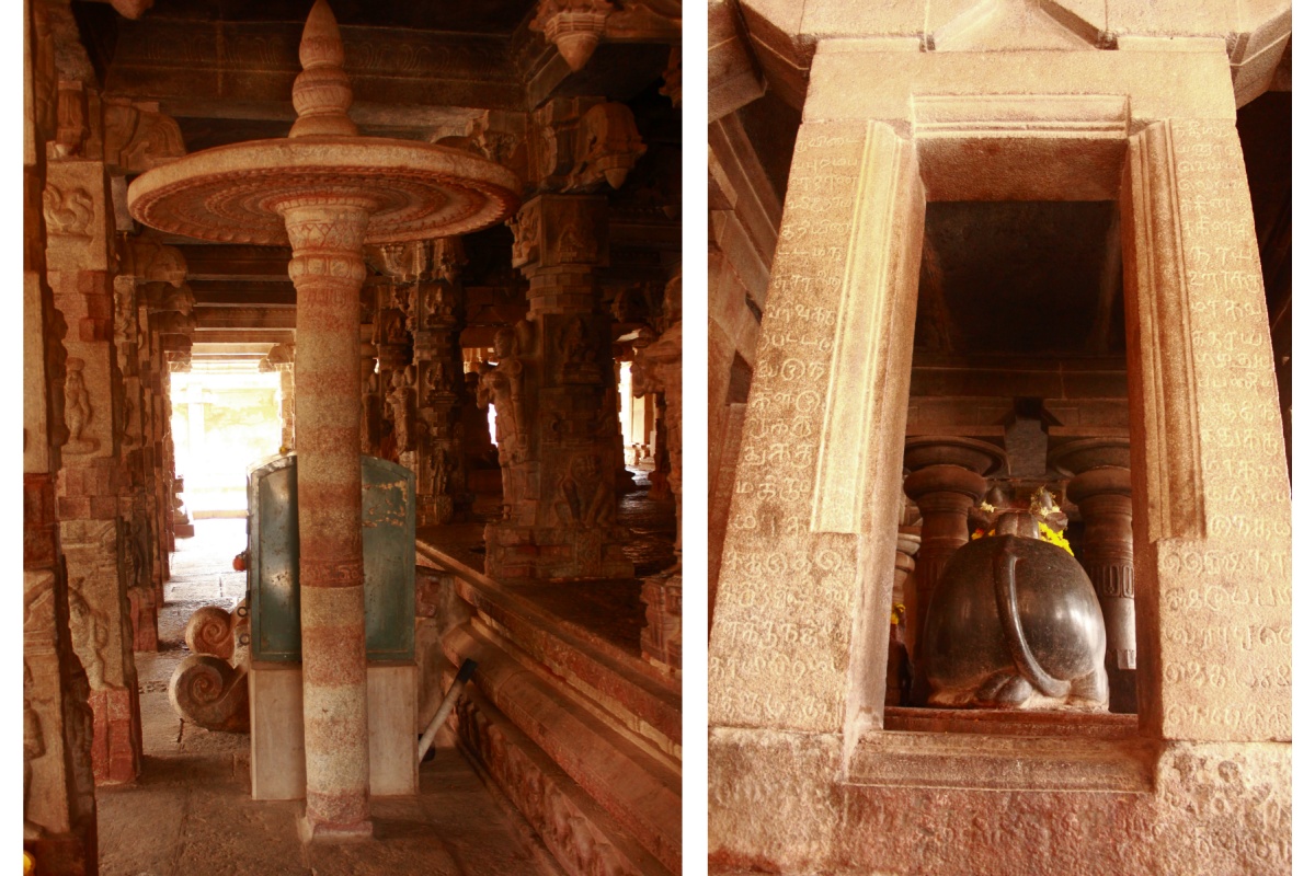
There's one object which is unique here- a stone umbrella! This is the first time I ever saw an umbrella made of stone. Within this mantapa are several inscriptions in Tamil.

This statue of Ravanausra is attention grabbing. Ravana in his true form; ten heads and ten pairs of arms.

The Garbhagriha drain, looks like the character here is yawning. Anyway, the details in the sculpture are amazing; wavy and curly hair, the bangles and fingers are well formed.

A granite slab with Telugu inscription. Window grill made of nine Ganas.

Fashionable attired women.

Man beating a drum, fingers stand out in the sculpture. The seated man seems to be making a clay pot.

A plump woman and a slender woman. The latter seems to be holding a fish in her hand.

Anjaniputra Hanuman. The man holding an umbrella seems to be appreciating something.

To the north of the main temple a gateway opens to a small enclosure in which are two Mantapas; Vasanta Mantapa and Tulabara Mantapa.

One more gateway to the north of the enclosure connects to a stepped well called as Pinakini Kolla. There are few larges fishes in this well. Besides few visitors there were half a dozen monkeys of various sizes. I guess the monkeys were hungry. One of the visitors threw in some popcorn like stuff for the fishes and two grownup monkeys were curiously watching the fishes gulp down food. It was interesting to watch the monkeys watch the fishes.. missed shooting the scene :-(

I must have spent over an hour looking around the sculptures on the temple walls, truly a marvelous temple. To see more about the temple do read a post on this temple by Rohini Kamath.
Back at the car, I woke up Sudhakar from his deep sleep, and we headed towards Nandi Durga on Nandi Betta.

.........