February 23, 2013
It was past 4-30 PM when we arrived at Shantagiri village, with a steep slope and no path in sight the hill looked unfriendly. The climb wont be easy and this is a type of village whose folks are not quite friendly. So, I was half prepared not to find a guide. Anyway, a old man told us to take our cab as far as the water tank. Thank to his suggestion, that water tank was ¼ way up. The remaining ¾ did not look far but the slope was pushing us backwards. To add to our problems, soil was loose and pebbles came loose under our feet. Malatesh took the lead, I was happy to be following :-)
This how the fort is in plan. Its perched at the hill top, at a corner. The strategic location gave a commanding view of the surrounding plains and a part of hill itself. The fort's important surviving parts are 3 bastions and one well. While two of the bastions are circular and third one, the main bastion is square in plan. Of the two northern walls, left and right are about 85 meters and 117 meters long respectively.
Malatesh taking a short break and studying the view of Shantagiri village from the fort entrance.
Close to the entrance is a 3' high platform, perhaps this is the foundation of another tower. In the back ground is the western bastion. The walls are quite damaged.
We start with the western bastion.. its a turret actually. Shooting slots have been made all around. Close to the base of the structure, in the rampart wall is a narrow passage linking the inside of the fort to the moat pit on the outside. We did not spend much time here, the place had a spooky feel.
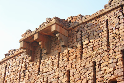
The square bastion is much taller than the bastion. At the base is a narrow door and at the top is a protrusion of a balcony. I suspect the structure was at least 8 feet taller, the upper wall has collapsed completely.
The passage is so narrow that only a slim person can enter it, that too side ways. We peeped inside, it wasn't bright but we could make out a heap of stones and remains of a stairway. Its a handsome structure. None of the neighboring forts- Belur, Wakkandurga, Kelur - has such a solid structure.
A closer view of the balcony and the plinth.
View of the fort and the moat. Notice the moat wall is lined with dressed blocks.
Rampart wall connecting central tower and the eastern bastion. Incomplete moat... the plan was to build a deep and wide moat.
Builders had designed a moat only when they were sure of availability of water. So back then water was plentiful, even on hill tops!
Ruins of a home or an office.
Now we have something interesting; a short canal connecting the moat and water tank. The rampart wall is to me back and the tank is out of view.
Here's the water tank measuring approximately 20' x 20' and 9' deep. The canal connection is on the left. It has a 3' wide platform around it and a enclosure wall with . The walls lined with black dressed blocks. At one corner is a short slight of steps to climb down into the tank when water level is low.
After seeing this water tank, I felt some of the constructions could be of Shivaji's time.
It was time to leave. We rest a while and plan our downhill route.
The climb down was quicker than expected. We still had Kodathgeri fort on our itinerary but it was too late. We decide to head back home...
.........


2 comments:
Hi , that a very interesting place. Can you highlight the history of the fort or the rulers who ruled the place?
MS, thanks for reading. Most of the small forts' historical information is lost. Even local people haven't been helpful. However, these forts were Chatrapati Shivaji and his successors. It is said that Maratha military had a signalling system using fire. Messages were communicated from fort to fort, thereby the message was sent over long distances without anyone actually traveling.
Post a Comment