Jul 26, 2014

Khasa Matha, Gurmitkal

The day which began with Buddha hill of Shahapur will come to an end at Khasa Matha of Gurmitkal, a Lingayath monastery. Buddha and Basaveshwara were both social reformers but of different time periods... more than thousand years between them. A book with the title "Buddha and Basava" written by Sri Kumara Swamiji of Tapovan, Dharwad has compared Buddha's and Basaveshwara's contribution to social development.

November 28, 2013
On the way back from Chandriki to Gurmitkal stopped at Khasa Matha. Generally I do not visit monasteries unless I'm asked to.. today my hosts Harisha and Papanna Alegar insisted on visiting this peaceful place. The Matha has a long history, it was established about 600 years back by Murugarajendra Mahaswami. The present seer of Khasa Matha is Sri Shantaveera Swami.

The Matha's main entrance has a richly decorated wooden door frame. At the lintel is a pair of leaping horses.

The gateway also has a balcony above the doorway. Probably that balcony is used by Swamiji to address disciples during special occasions. The balcony columns on the front is a unique work of sculpture fixed into it. It is a monolith sculpture; a 5" diameter cylindrical shaft about 3' in length with 3 grilled cages; each of the grilled cages holds a stone ball. However, only one of the shafts survives today.


Check out this video to see the unique sculpture. This boy, a resident of Khasa Matha shows the ball movement in the cage.


grilled cage and enclosed ball
Moments before sunset.. shades of gold and pink light up the cloudy sky. The matha had a peaceful ambience.. a group of kids sitting on the floor in a circle reading their school books.. matha resident boys running about doing their chores, preparing for evening pooja. Oh what a place!

A saffron flag flutters in the gentle breeze.  On the left is the gateway passage and on the right is shrine.. tomb of the founder Swamiji.

There's another courtyard which is much smaller. In the center is a stone cauldron, about 3' diameter and 2' high. Its hollow inside. The dent on outer surface gives it a special touch.. as though it fell down and got deformed. Probably thi cauldron was used to store water or oil originally, now its just a show-piece gracing the smaller courtyard.

Swamiji was yet to come out to for the evening. In the mean time I freshened up at the bathroom.. the cool water was refreshing. We waited few minutes in the open hall next adjoining the smaller courtyard before Swamiji showed up. This is Poojya Shri. Shantaveera Swamiji the present head of Khasa Matha of Gurmitkal.

Papanna being a regular visitor to this Matha introduced me to Swamiji and then I told about myself and how I happened to be sitting here.. thanks to Papanna. We spoke about the forts and weather among other things. One of the topics discussed was Kakalwar Samsthana. At the end of the discussion Swamiji presents Papanna a picture of Raja Lakshmanappa.

I told Swamiji about my plan to reach Shahabad tonight and requested to grant us leave. Swamiji and Papanna asked me to stay back for the night however since my plan was set and so was my cab's return to Dharwad, I had to leave.

The audience has grown with three other visitors, they were here to seek Swamiji's advice on something important. During this visit I did not get an opportunity to ask about Matha's history. Anyway, the moment I stepped in, I had a strong feeling my relationship with this Matha is going to be long one.. there will be more visits.
.........

Jul 19, 2014

Chandriki fort

Gurmitkal and Chandriki forts were discovered while exploring Yadgir district on Wikimpia. Both names are unique, very different from all known place names.

November 28, 2013
About couple of hours ago at Gurmitkal fort I met two locals- Harish and his uncle. They were friendly and knew some history of their place. Its because of them I got to see few spots in Gurmitkal which would have been missed otherwise. They along with another friend, Papanna Alegar agreed to accompany me to Chandriki. Just outside Gurmitkal is a Lingayath monastery called Khasa Matha. Papanna Alegar said we'll stop there but I insisted we see the fort first.

Between Gurmitkal and Chandriki there was a light shower, it ended as abruptly as it started. The road went up and down graceful slopes and soon we entered Chandriki village. The lanes were really tight, we could drive till a school. The fort was a short walk from there. Again we were walking through paddy fields, harvesting was over few weeks back. As the fort came into view, it was another surprise - another mud wall fort. Looks like forts in this region are of this design.

Chandriki fort covers a larger area than Gurmitkal fort, probably double the size. This fort might have a dozen bastions. Very close to the fort is a small lake.

A small gateway in the southern wall. We could enter from here because of thorny bushes.

According to Papanna, Chandriki belonged to Raja Lakshmanappa's kingdom which comprised of 184 villages. The Raja ruled from Kakalwar, about 6 kms northwest of Gurmitkal. It is said that Raja Lakshmanappa ruled independently, he did not pay taxes to Nizam.

That's our gang- a local boy, Mama, Papanna Alegar and Harish. In the background is the fort entrance. To enter the fort one has to take a curved path, a security measure to slow down enemies in case of a frontal attack.

This isn't the actual entrance. The wall on our right (a semi-circle in plan)is the there to conceal the fort's main entrance - perhaps, its ok to call it a curtain wall or a shield. The space enclosed between the fort and the shield is a place to trap enemy forces.

Different levels of the wall can be identified here- 6 levels are seen here. Builders have even made gun holes (see inset).

Close to the entrance is a small temple built into the rampart wall. I dont remember seeing any deity inside however close by was a little sculpture..


..of Lord Hanuman. Looks more like a running baby Hanuman.

That's the main gate of Chandriki fort. Looks like even this fort was taken over by Nizam's forces.

Within the fort is a stepped well, grand like other wells we saw in Gurmitkal. In fact we saw another well on the outskirts of Chandriki village. This particular well could be 400 years old. May God protect this region, may the water level remain this way always.

So much of planning and work have been done for water - and they have survived until now.

A mantap or a royal shelter. Over the well's water was a weaver bird nest (see inset).

We make our way to the fort's temple, its a big temple. The temples are high and have a fort like quality. This was no ordinary temple, looks like treasure was stored here for safe-keeping. This is the main entrance with a big arch.

The second gateway with a smaller arch.

The temple's mukhamantapa ~ verandah. Notice the detailed panel above the lintel.

In the Garbhagudi was this simple looking Shivalinga, lit by setting sunlight. Normally you see east facing temples but here at Chandriki we have a west facing temple. One other such temple is at Siddanakolla near Badami.

A large Basavanna in the Mukhamantapa. Within the temple walls was a pair of oxen taking a break after a day's work, they were feeding on hay. Those ox were just like the Basavanna here.

Isn't the stone ox similar to the flesh and blood ox, especially the head?

Again nothing much remains within the fort. With light fading we decided to leave. Back at the fort's entrance.I wonder if earth for constructing these walls was sourced locally.

Nearby in the field was a half buried ancient sculpture.

Back to the cab, we drove towards Gurmitkal. Papanna Alegar insusted we stop at Khasa Matha and meet Swamiji. Yes, Sir.

A week later when I was back home Papanna Alegar had called me to tell about the desecration of Shiva Linga at Chandriki fort. They said the miscreants had dug up the Garbhagudi floor in search of buried treasure and in the process Shiva Linga and its pedestal was disturbed and damaged. They said the news was reported in media and people were on looking out for those miscreants. This had to happen just after my visit! In their point of view- a stranger visited our temple and this happened. Is that stranger involved? Anyway, I'm in touch with my friends on phone and sent them pictures. I believe that incident has not colored my friends' minds.

Chandriki fort coordinates:  16°51'51"N   77°26'45"E
.........

Jul 12, 2014

Gurmitkal fort

November 28, 2013
First half of Nov 28th was spent at Sannati-Kanaganahalli archaeological site. For the second half Gurmitkal and Chandriki forts were on the itinerary. We reached Yadgir around 1-45 PM, located a Lingayath Khanawali where we had lunch and then immediately left to Gurmitkal, about 45 kilometres away. The tree lined state highway was excellent, about 20 kms, the terrain changed. The road was twisty, climbing gradually, the hills were climbing were covered in carpets of green grass - I had not expected this. At one point, I noticed a fort like wall lining a slope next to the road. Soon we reached Gurmitkal, we asked our way to the fort, crawling through narrow streets of Gurmitkal. Suresh parked close to the fort's main entrance. Opposite the main entrance  was a temple and a nursery. The orange colored structure is the temple and on the left is the entrance.

A curved path leads to the gateway arch.

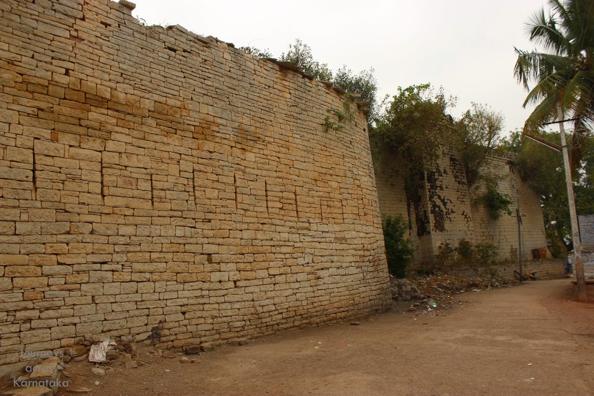
The fort's first sight surprised me. Its very different from the forts seen until yesterday. Rampart walls are made of stone and earth; the lower portion is stone wall, like a foundation and the upper portion is packed earth. Isn't it awe inspiring that these 800 to 600 years old walls are still standing. The builders have even made merlons. This is amazing.

Fort entrance as seen from inside. The gateway structure is made of black dressed blocks.

Lets take a closer look at the wall. Cross-section of the wall can be seen at this collapsed portion. The wall is tapered, wide at the bottom and marrow at the top. On the inside, earth is heaped against the wall - this is done to increase the mass which in turn increases the impact strength of the wall.. in case enemies pound the wall with cannon fire. The heaped earth also provides a platform for soldiers. I think these walls were plastered regularly back then. At present, due to lack of maintenance, the walls are corroding. See how earth has eroded from the merlons (see inset).

The fort has one well. What was once a grand structure is now neglected completely. Water level was barely 10' below ground level. Close to the well is a house, I asked the occupant if he could show me around. He agreed, I can't remember his name.. he was a Muslim.

He lead me through a foot path which went around the fort. Jaali Gida had covered most of the area, there was little we could explore. That ancient structure must have been a part of a palace within the fort.

This is probably the northern wall.

Another view of the ancient structure, it is occupied, probably another Muslim family. This region was part Nizam's kingdom, hence many forts close to Karnataka-Andhra border are occupied by families serving the Nizam.

Part of western wall- rampart wall and a crumbling bastion.

There wasn't much to see here, I came back to the fort entrance. In the temple were two men, I asked what else was there in this fort and town of historical importance. Harish, the younger of the two asked me if I had seen Ramteerth Bhavi. No, can you show take me there. Yes, let's walk, its half kilometer away. In two minutes we were out of the town and walking in paddy fields.

Where the fields ended was a stream across our path. Water at this time of the year is less, we could jump over rocks and cross the stream without wetting our feet.

Close to the stream is a single floor building enclosing a well within its walls. Around the perimeter is a long hall which could be used for performing rituals or to beat summer heat.

Architecture is similar to structures in Bijapur, Gulbarga, Bidar or Golconda. I wonder if this originally was a place of worship later converted by Muslim rulers into a summer retreat.

I had noticed something.. weather is much cooler. I felt Gurmitkal area was 5 degrees cooler than Yadgir. Also noticed the water levels in wells are high, presence of water could be a reason for cooler weather.

That's Harish. The other person, not in sight is his close relative. Harish and his Mama ~ maternal uncle conversed in Telugu. I think Mama did not speak Kannada. This well is surrounded by paddy fields.

We walk back to the town. Harish insisted on introducing his family friend, Papanna Alegar. Together they wanted to show me few other spots of historical importance like the seven wells of Gurmitkal and a cannon. I told them about my plans to visit Chandriki fort, they knew and agreed to accompany me to Chandriki. As we drove through the town we first stopped at Nijasharana Ambigara Choudayya Vrutta ~ a junction named after a XII century Lingayath named Choudayya, a contemporary of Basaveshwara. At the memorial is a canon found at Gurmitkal fort.

According to Papanna, Gurmitkal was part of Raja Lakshmanappa's kingdom which comprised of 184 villages. The king ruled from Kakalwar, about 6 kms northwest of Gurmitkal. It is said that Raja Lakshmanappa ruled independently, he did not pay taxes Nizam. The king had six brothers and one sister. Gurmitkal town has seven wells, one for each of the brothers and a temple dedicate to the sister Yellamma. This is one of the wells- notice how high the water level is.

Close to the well are columns sans arches. This was one of the gateways on the outer wall of Gurmitkal fort.

Harish told me about another popular spot close by- a waterfall. Mama called it Dabdaba. They insisted on driving down to the waterfall. Since time was a constraint, I chose Chandriki fort, about 6 kms away.

I'd never imaged this place would be hilly, have flowing streams in November, have such cool weather, and waterfall to top it all. I fell in love with Gurmitkal. I want to come back here, stay a day or two, visit Kakalwar and explore the surrounding area.

Thanks to Papanna Alegar and Harish.

Gurmitkal fort coordinates: 16°52'10"N   77°23'37"E
.........

Jul 5, 2014

Shahbad fort

November 29, 2013
We reached Shahabad town outskirts around 8-45 PM, I was hoping to find a hotel but somehow the looks of the town was not encouraging. We missed a left turn to the town and ended up going around the town (I have no words to describe the condition of the road), with some difficulty we reached the town, it was close to 9-30. The town looked as though it was bombed, we could see just ruins every where. I spotted a khanawali, decided to have a meal before it closed. Then I checked out Indian Hotel, the place was chaos, a wedding party had camped there and the wedding hall was part of the hotel building. Forget it. Close by was another one - Karnataka Hotel, the building was dark, no light inside or outside. We drove back to the main road, saw the police station.. thought policemen should help get some accommodation. No such luck, I was asked to drive to Gulbarga - that was the best thing I could do. It was around 12-30 when we checked into a hotel in Gulbarga.

November 30, 2013
Morning we left the hotel by 5-45. First we visited Malkhed fort, drove back to Gulbarga and then to Maratur. Rather than going back to Gulbarga-Shahabad road, we took the inside road linking Martur and Shahbad. We saw number of stone quarries - sources of the famous Shahbad stones. As we entered old Shahbad town, I inquired about the fort, it was easy to find. There we are- facing Shahbad fort main entrance. This spot is know as Ashoka Chowk ~ Ashoka Square, named after emperor Ashoka.
Somehow the village atmosphere wasn't good, people weren't smiling, I could sense hostility. One of the men asked me where I was from. Dharwad. The man responded back "so the case has been moved to Dharwad court, is it?" I was wondering what on earth is this man talking about. Few seconds later I got it; these people thought I was a policeman and I was here to investigate some case. I told the group that I was a tourist, forts are my interest and left..

The very look of the ruins is an indication that the inside can be even more filthy. I decided to go around the fort.

As you see, this fort is another example of Shahbad stone construction. When this ancient structure is compared with any of the recently constructed houses, there's not much of difference. Basically limestones blocks are stacked carefully to form walls. Coming back to this fort, a row of gun slits can be seen in the walls. Shahbad stone technology had evolved long time back.

On this street, one of the families was friendly, I was inquiring if they knew historical facts. Answer was no. Suddenly a drunk man sprung into the scene, he started yelling at me, waving his arms wildly.. who are you? why are you shooting pictures? who gave you permission? I was shocked for  moment but remained calm and let him yell. A minute later I told him my interest is historical monuments, I'm here to see the fort. He threatened that he can have me abducted! I smiled and told him its not easy. I continued shooting. Few minutes later he cooled off and also people around asked him not to behave badly with a visitor. I really did not know how many were trustworthy here.

Upper level of a bastion. Tapering three layered supports hold the overhang.. functionality and aesthetics are hand in hand.

 This is the western wall and bastion.. this side is pretty well preserved.

The fort is oddly shaped in plan, looks like it was expanded on a adhoc basis.

My tipsy friend accompanied me till this corner and asked me to be careful. I thanked for his valuable advice and asked him to quit drinking. This is the rear of the fort, a square bastion occupies the south-eastern corner of this fort.

The rear exit. This fort, once a grand dwelling, a power centre, today is a filthy dump used like a public toilet by half the town.

The eastern wall and a badly crumbling bastion.

 However the bastion top has somehow survived. The overhang is supports are similar to the bastion on the opposite side.

I come back to the front of the fort. A small portion of the fort area is utilized by a primay school - Saraswati Vidya Mandir.

I come back to Ashoka Chowk, Suresh the cab driver was napping, as usual. across the street is this ancient temple with a heavy touch of colours. Local boys wiling away time.

A couple of kilometers from here (on Maratur-Shahbad road) was this limestone quarry. It was amazing to see perfect layers of sheets, as though someone had buried a stack of them.
A couple was at work, they were dislodging a block. Suresh, who was already over by looking at houses was toppled after looking at this quarry. He inquired price for a truckload, he was thinking of business idea.. buy stones here and sell them at Dharwad.

Yesterday I was at the archaeological site of Sannati, looking at the ruins of an Ashoka era Stupa. The Stupa's parts were made of limestone i.e. Shahbad stone. The history of limestone blocks for construction technology is more than 2200 years old. Besides Shahabd fort, Malkhed fort and Maratur fort are also built of limestone blocks.

Close to Shahbad are two shrines- Sharanabasaweshwara temple and Ramanadevi temple.

Shahbad fort coordinates: 17°8'27"N   76°55'50"E
.........