Showing posts with label Bellary district. Show all posts

Sep 12, 2020

what to see in Ballari district (prior to bifurcation)

There are several stories around the name Ballari. The first story attributes Ballari to Balleshwara which is derived from the word Balla, meaning a dome shaped measuring cup. The story is that a devout merchant community which halted here could not find a Shiva Linga. An upturned balla, symbolic of Linga, was used for the ritual. The shrine remained and a temple was built for it. The temple still exists and remains popular attracting huge crowds during Maha Shivaratri. The other story attributes the name to the story of Lord Indra slaying a demon named Balla. After slaying the demon, Indra was called by the name Balla-ari which means the slayer of Balla. These are the two folklore behind Ballari's name. However, historians say that Ballari might have been derived from Kannada words Vallari and Vallapuri mentioned in an inscription belonging to Talakadu Ganga dynasty.

During the British rule, Bellary district was part of Madras Presidency. The district covered a large area including the present day Kurnool and Anantapur districts. In 1957, Madras state was divided on linguistic basis. Areas with significant Kannada speaking population were transferred to Mysore State (which later became Karnataka state) and areas with Telugu speaking population were transferred to Anatapur and Kurnool districts. When Bellary district was formed it had eight taluqas, and in 1997 Harapanahalli taluq was transferred to Davangere district.

Ballari is part of Bayaluseeme (flat land) but with plenty of hill ranges and rock formations which is more or less similar to Chitradurga district. River Tungabhadra flows along Ballari district's western and northern border which is shared with Haveri, Gadag, Koppal and Raichur districts. Ballari district is known for its iron ore deposits, steel plants and power generation plants. Hampi and Ballari fort are popular tourist destinations. Besides the main stream tourist spots, within the boundaries of Ballari district are a large number of pre-historic sites, prehistoric ash-mounds, two rock edits of Samrat Ashoka's period and several smaller forts. Bellary has the distinction of having the biggest Neolithic tools manufacturing center at Sangankallu and hundreds of prehistoric petroglyphs at Kappagallu. For one with interest in prehistory, this district offers great adventure and exploration.

Anantasayanagudi, Bellary fort
Charkratheerta, Shilpavana at Hampi Kannada University

Hampi Virupaksha temple street, Elephant stables
Stepped tank near Mahanavami Dibba, Lotus Mahal in Zenana enclosure

Shri Ujjaini Saddharma Peetha, Ashokan edict of Nittur
Ashokan edict of Udegola, Tekkalakote fort 

Prehistoric anthropomorphic statue of Kumati, Megalithic tomb of Kumati
Prehistoric grinding stone at Sangankallu, Petroglyphs at Sangankallu

Jogikal fort, Narihalla at Sandur
Rock shelter with prehistoric paintings at Gudekote, Ash-mound of Kudatini

Here is a list of places to see in Ballari district.
  1. Ballari fort - one of the largest hill forts of Karnataka. The formidable fort is situated on a massive monolithic hill called Ballari Gudda at the center of the city. The original fort was constructed during Hanumappa Nayaka's rule and later expanded by Hyder Ali. The builders have integrated natural boulders into the line of defense. The walls are 15 to 20 feet high and 12 to 18 feet thick. Turrets have been strategically placed in the outer walls. At the summit is the core of the fort large enough to house several hundred people. The fort also has number of rainwater collection tanks, both natural and man-made. The fort's gateways have winding paths passing through them designed to confuse enemy forces. To the fort completely, one will need a full day.
  2. Tungabhadra dam, Hospete - As the name indicated this is a dam across river Tungabhadra, situated on the western side of Hospete city. The dam is built of granite blocks bound with Surki Mortar (a combination of mud and limestone). The construction began in 1947 and completed in 1958. The dam is 2449 meters wide and 50 meters at the deepest point. Below the dam is a well maintained garden with musical fountain. The dam garden is open to public during certain hours.
  3. Anantasayana Gudi - This village is named after its colossal temple of the same name. The temple of massive dimensions has a single Garbhagudi with three doors - which is unusual in Hindu temples. The Garbhagudi, designed to house a huge reclining idol of Ranganatha, has a huge vault dome. However, this temple has no deity. Anantasayana Gudi is situated 10 km from Hampi and 3 kms from Hospete.
  4. Muhammadan Tombs of Kadirampuram - There are two structures built in Bahamani architecture. One can consider this a small necropolis. Kadirampura is situated on Hampi-Hospete road, 3.5 km southwest of Hampi and 9.5 km from Hospete.
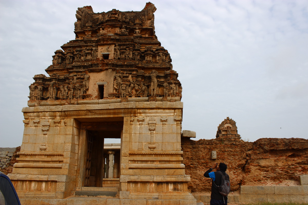
  5. Hampi - Hampi was the place where Vijayanagara Samrajya was born and served as its capital. The ancient capital, now a village of ruins, is situated on the left bank of river Tungabhadra. The name Hampae has been derived from Halae-Kannada word 'Pampaa' which means great. Hampi is a sprawling collection of standalone temples & temple complexes, water tanks & canals, mantapas, fortification structures, military barracks, royal enclosures, stables, market places, memorials, water structures, and natural hills & rock formations. There's a saying in Kannada which goes like this- those with good eye-sight must see Kanakagiri, those who can walk must see Hampi. Its true, to really see the monuments of Hampi, one must walk and be willing to spend a week.
  6. Kamalapura - Being in the immediate neighborhood of Hampi, Kamalapur too is a historic town. This place was the residence of Anegundi king. In the south-eastern part of the town are ruins of a fort and a watch tower. Close by is an ancient well which is believed to be sacred to Brahma. Kamalapur is also home for Hampi Archaeological Museum. Just outside the north-eastern corner of the town is Pattabhirama temple complex which was built during Vijayanagara rule. Kamalapur is about 5 km south of Hampi and 12 km northeast of Hospet.
  7. Kannada University - Kannada University, also called as Hampi Kannada University or Hampi University is a research-oriented university founded in 1991. The aim of this university is to develop Kannada language and to promote literature, traditions, culture, and folklore of Karnataka. The campus has a peaceful, garden like ambiance. In the main building is a museum of ancient artifacts. Set in the natural rock formations is Shilpavana, the garden of stone sculptures which are present day creations by the faculty and staff of this university. Kannada University is situated 12 km south of Hampi.
  8. Kampli - This fortified river town has been an important place right from Chalukyan times. Situated on the right bank of Tungabhadra, it was one of the capitals of Chalukya kingdom in mid XI Century, a stronghold of the Anegundi kings and an outpost of Vijayanagara. The fort is built of the dark colored stone available in the riverbed. Kampli's warrior king  Kampli Raya and his son Gandugali Kumara Rama died fighting the invading Muslim forces. Kampli is noted for wood-carving, manufacture of toys and coracle making. On the outskirts of the town is an ancient shrine dedicated to Pampapathi. Kampli is situated 33 km northeast of Hospete and 22 km from Kamalapura.
  9. Daroji Bear Sanctuary - This sanctuary spread over 80 sq km is dedicated to the preservation of the endangered sloth bears. Being an endemic species, the rough terrain of Daroji is a natural home to sloth bears. The sanctuary is open to public during day times and entry is chargeable. Daroji sanctuary is situated 50 km north-west of Ballari and 20 km south-east of Hampi.
  10. Shrimad Ujjini Sadharma Simhasana Mahasamsthana - Ujjaini is one of the Panchapeethas along with Baalehonnur, Kashi, Kedar and Srishaila. Marulasiddeshwara (also known as Maralusidda), a contemporary of Basaveshwara, is the founder of Shrimad Ujjaini Sadharma Simhasana Mahasamsthana. The temple within this Matha complex is believed to be his Aikyasthala. Maralusidda had worked with Basaveshwara for the good of the society during the Kalyana revolution in XII Century. Ujjaini is about 63 kms Northeast of Davangere and 26 kms from Jagaluru.
  11. Bairidevara Kote - An ancient hill top fort with a temple dedicated to Bairideva. The rocky outcrop sticks out from its surrounding plain land. Bairideva hill is about 4 kms north of Ujjini.
  12. Palayyana Kote - An ancient hill top fort which might have served as a residence for Palegaras who watched over the surrounding plains. Palayyanakote is about 12 km northeast of Ujjini.
  13. Jogikallu fort - This is a small fort built on a rocky outcrop. Within the fortification is a group of temples. The fort is small, has four or five bastions. The name Jogikallu is comprised of two Kannada words Jogi + Kallu. Jogi somewhat means Yogi and Kallu is stone. Halae Jogikallu is situated 36 km northeast of Ujjini and 12 kms from Kudligi. 
  14. Halaekote ruins - The word Halaekote means old fort. This village is situated in the plains between two hills with scattered rock formations. On the hills are ruins of fort walls, it looks like the fort construction was abandoned much before completion. The village has number of temples dedicated to Veerebhadreshwara, including one temple on the northern hill. Halekota is 6 kms south of Siruguppa.
  15. Kenchanagudda - This village is situated on the right bank of Tungabhadra. Here are ruins of fortifictions, one on the hillock and other close to the base of the hillock. The fort on the was residence of a local chief named Kenchan Gowda. An inscription dated 1708 CE at Gangadhara Devastana here gives the genealogy of Kenchan Gowda. There's another inscription in the cave of a holy-man named Siddha Mallayya. Also, in this place is a Brindavana of a disciple of Raghavendra Swami. Kenchanagudda is situated 7 kms west of Siruguppa.
  16. Sandur - Sandur was the capital of the Sandur State, a small principality, ruled by the Ghorpades. The town is reachable through three passes, Bhimanagandi near Taranagar, Obalagandi towards Yeshawantanagar, and Venkatagiri pass. The name of the town is derived from combining two Kannada words: sandi (narrow gap) + uru (town) = Sandur. It is also said to have been called as Skandapuri after Kumaraswamy (Skanda) shrine. Sandur is well known for its picturesque landscape, an ancient palace, ancient shrines. There's a saying which goes like this: "See Sandur in September" i.e. just as the rainy season ends, when the hills are green and streams are flowing. A popular Kannada cinema "Manasa Sarovara" was shot in this beautiful land. Sandur is a great destination for treks in the mountains and boating in Nari Halla. Sandur is situated 52 km west of Ballari.
  17. Sandur fort - Sandur fort - This fort situated on plain land is square in plan. It has a zigzag entrance and bastions. Going by the architecture of this fort, it seems to be originally built by a Hindu king. Later it was taken over by Hyder Ali and some modifications were done. This fort is called as Krishnanagar fort. The fort is situated on the northern side of present day town.
  18. Shiv Vilas Palace - This was the palace of Gorphade family now a heritage hotel.
  19. Krauncha Giri - This place is known for two ancient temples dedicated to Parvati and her son Karthikeya. Legend says this is the first shrine of Karthikeya in south India. Parvati temple, built in Badami Chalukya architecture, is unique in design and form. The Shikhara is very different compared to other temples of the same period. As to Karthikeya temple, currently called Kumaraswamy Devastana was constructed during the rule of the Rashtrakutas between VII and X Century. Krauncha Giri is situated 11 km south of Sandur.
  20. Gandi Narasimhaswamy Devastana - This is an ancient shrine situated on the edge of a hill. Besides the shrine, the place is a picturesque spot. Close to the temple, a stream flows which cuts through a massive rock formation. This spot was one of the locations of "Manasa Sarovara" cinema. Gandi Narasimhaswamy temple is situated 4.5 km on Sandur-Yeshwantnagar road.
  21. Ramanadurga - This hill fort is said to be built by the warrior prince Kampli Kumara Rama. Within the fort is a shrine dedicated to Ramadeva. It is said that Kumara Rama was kept hidden for some time for his own safety. The other interesting thing is the Trigonometrical Station here, which is at a height of 3256 feet from the sea-level. The hill is such that on all its sides, the ground falls sharply, thus giving excellent views. Ramanadurga is about 16 km from Sandur and 20 km from Hospete.
  22. Hulikuntaraya Devastana, Bommaghatta - This is an ancient temple dedicated to Hulikuntiraya (another name for Anjaneya). Within the temple premises is an ancient stepped well. It is said that Sri Vadiraja Theerta (1480 – 1600 CE) had performed pooja here. Bommaghatta is situated about 27 kms south of Sandur.
  23. Prehistoric Ash Mound of Kudathini - This is an important Neolithic site. The ash-mound measuring 700 feet x 150 feet (at its widest) is said to be several thousand years old. Archaeologists have found pottery shreds of large vessels by excavating this mound. Also, burnt & unburnt animal bones have been found in this mound. Kudatini is situated west of 26 km east of Ballari and 28 km northeast of Sandur.
  24. Sangankallu Neolothic hill complex - This can be called as the largest Neolithic site of Karnataka. On this group of hills was the Neolithic tools manufacturing center. Stones was quarried and tools like axe, spearheads and grinding stones were made by ancient people. Even to this day one can get to see axe-head, spear-head and heaps of chips as a result of manufacturing activity. For one visiting this hill, its suggested to engage a guide from Sangankallu village. This Neolithic complex is 10 km northeast of Ballari. 
  25. Petroglyphs of Kappagallu - On the northeastern face of the Neolithic complex is Dolerite dyke, a heap of dark colored stone. On these stones are hundreds of petroglyph (image made by scratching the surface) believed to be made ancient people. The images depict bulls, birds, serpents, tiger, humans, and formations of human group dances. Anyone trying to explore this part of the hill must be accompanied with a local person and physically fit to endure the clambering over jagged rocks. 
  26. Prehistoric Ash Mound of Kappagallu - Close to the base of the hill in the vicinity of the Dolerite dyke is light-grey colored mound which is actually prehistoric ash. This is one of the few ash-mounds remaining in Karnataka.
  27. Beerappa rock shelter - To the northeast of the his rock-formation is an ancient shrine. Even to this day local people perform rituals here. Once can find several red-colored paintings on these rocks. There is a possible connection to the Neolithic hill complex. 
  28. Kurugodu fort - Kurugodu was under Palayagar Hanumappa Nayaka, the builder of Ballari fort. Devappa Nayaka, a descendant of Hanumappa Nayaka, built this fort on the rock strewn hillock in 1701-02 CE. Within the fort is a shrine dedicated to Lord Hanuman hence the name Hanumantana Gudda. Hyder Ali captured this fort in 1775 and reinforced it. The fort seems to be in ruins but rituals take place in Hanuman temple.  
  29. Dodda Basaveshwara Devastana, Kurugodu - This is a historical village where inscriptions dating back to the VII Century CE i.e. Badami Chalukyan times, have been found. During Kalyana Chalukya time, Kurugodu was the chief town of Ballakunde-300 and later this was an important centre during the Western Chalukya rule. However the place lost importance during Hoysala rule. Kurugodu is known for Dodda Basaveshwara Devastana. The main deity being a large Nandi which is about l2 feet tall. Kurugodu is situated 28 kms north-west of Ballari.
  30. Sangameshwara Devastana, Halae-Kurugodu - This beautiful temple dedicated to Sangameshwara is situated at the base of a boulders-heap on the western side of Kurugudo. This place is called as Halae-Kurugodu meaning old Kurugodu. Probably the town existed here originally and later shifted to the present location. Besides the temple there's a large idol of Ganesha. Local people call it Dodda Ganesha. About 350 meters east of Someshwara Devastana is another ancient temple called Siddeshwara Devastana.
  31. Varavina Malleshwara Devasthana - This place is like a miniature version of Hampi sans river. The scattered ruins, the architecture and the presence of a Frangipani tree was very much Vijayanagara style. It is said that this place was known as Devara Kallu once upon a time. Varavina Malleshwara Devastana is situated next to rocky hillocks 4 km east of Tekkalakote.
  32. Nadivi fort - This is one of the river forts on the right bank of Tungbhdra. The fort must have been an outpost during Vijyanagara times. The fort was approachable by boats only when water level in the river was high because of a large rock formation in the river bed. Within the fort is a shrine dedicated to Ramlingeshwara. Nadivi is 10 km southwest of Tekkalakote.
  33. Tekkalakote fort - In plan this fort is square-shaped, the walls are approximately 20 feet high and has four bastions, one every corner. The fort's entrance is on its north side. Also there's a small side entrance. The fort seems to be constructed during Vijayanagara times and ruled by  Hanumappa Nayaka's descendants before it came into Muslim rulers' control. There are several other places of interest around Tekkalekote such as Hudeda Gudda (a prehistoric site), Emperor Ashoka's two minor rock edicts at Udegola and Nittur, and Varavina Malleshwara shrine. Tekkalakote is placed 46 km north of Ballari city.
  34. Hudeda Gudda - This hill is one of the largest pre-historic sites in Karntaka. The hill is covered with rocky outcrops, several of them are natural shelters fit for human dwelling. In these rock-shelters, prehistoric art depicting bulls and human beings performing group dance have been found. During the excavations of 1964 by Shri M S Nagaraja Rao, artifacts belonging to the new Stone Age period dating back to 1700 BC -1000 BC were found here. Polished stone axes, weapons made of flint stone, gold ornaments, copper, beads, pottery shreds, clay utensils, cysts and bones were among the findings. Hudeda Gudda is situated 2.5 km southwest of Tekkalakota fort.
  35. Ashokan edict of Nittur - This is one of the nine rock edicts of Samrat Ashoka in Karnataka. The site is protected, under the care of ASI. Ashokan inscription of Nittur is about 6.5 km west of Tekkalakote and 4.5 km north of Udegola.
  36. Ashokan edict of Udegola - This is one of the nine rock edicts of Samrat Ashoka in Karnataka. There are two sub-sites- #1 and #2 which are 150 meters apart. The site is also protected, under the care of ASI. Ashokan inscription of Udegola is about 10 km west of Tekkalakote.
  37. Kogali - Today a small village was earlier a chief town of a sub-division called Kogali-500 under Nolambavadi-32000. It was also once an important Jaina centre. Here is a Jaina Basti with a lifesize idol of a Teerthankara. Also inscriptions belonging to the Chalukya, Hoysala and Vijayanagara periods were found here. Kogali is situated 21 km southwest of Hagaribommanahalli.
  38. Viranadurga - The name Virana + Durga means brave one's fort. This is a small fort situated on a ragged granite hill. The fort is accessible only from north and impregnable on other sides. It is said that Tipu Sultan's attack on this fort was a failed attempt. Viranadurga is about 6 kms south of Kudligi and a kilometer km west of Moraba.
  39. Jaramali fort - Also spelled as Jermali, is a small village next to a rock hill. The hill is approximately 800 feet high and a landmark in this area. Atop the hill is a fort in ruins. It is said the fort was residence of a Palayagar family. Jarmali is about 14 km south-west of Kudligi.
  40. Gudekote - After the fall of Vijayanagara kingdom, among the several Palayapattus (principalities headed by Palayagara chief) came into being. Gudekota was one Palayapattu, subordinate to Bilechodu Palayagar dynasty of Chitradurga. Gudekote thrived until its take over by Hyder Ali in the year 1777 CE i.e. two years prior to the fall of Chitradurga. This village is situated between three rock-strewn hills, which are like protective barriers. On the north-western hill is a fort dating back to Vijayanagara times. Close to the entrance of the fort is a rock-shelter with ancient paintings. Within the fort are two water tanks and a brick-mortar structure. The village has remains of several small temples and a royal looking brick-mortar structure. The village has a water tank named as Bommalinganakere. Gudekote is situated at a distance of 32 kms east of Kudligi.
  41. Prehistoric paintings near Gudekote - A kilometer away from the town on Gudekote-Rampura road, where the road turns sharply is a huge boulder with a concave face. There's a small red-colored painting on the rock which is definitely prehistoric. Also, in the vicinity are many natural rock shelters which could possibly have paintings in them.
  42. Antropomorphic statues of Kumati - This is a peculiar pair of standing statues made of granite slabs. The statues are approximately 9' and 11' tall, 20' apart. Local people associate these statues to two accursed Rakshas turned into stone. Also, on the other side of Kumathi village is a prehistoric megalithic tomb. Kumathi is situated 75 km southeast of Ballari and 23 km south of Gudekote. 
  43. Amaradevaragudda - This village's name is derived from the hillock there. On the hillock is a ruined fort. Also, this place is known for a huge Banyan tree. Amaradevaragudda (A D Gudda on Google maps) is about 3½ kms east of Kudligi.
  44. Kottureshwara Devastana, Kotturu - This temple is dedicated to a Lingayath Guru of XVI Century CE, named Kottureshwara. The temple is a popular pilgrim center for Lingayaths of central Karnataka. The temple's annual fair attracts thousands of people. In facts people walk from their homes, covering great distances bare-footed. Kotturu is 103 km east of Ballari, close to Ballari-Davangere district border.
  45. Huvinahadagali - The name Huvinahadagali can be split into 'Huvina + Hadagali' together it means boat made of flower. The story goes back to Vijayanagara times when this place was known to flourish in the trade of flowers. This village has several Chalukyan temples namely Kalleshwara, Chennakeshava and Suryanarayana. Also there are temples dedicated to Hanuman and Panduranga. Though most temples are in poor state, the delicate sculptures are worth seeing. The fort of Huvinahadagali was demolished in 1866. Huvinahadagali is situated 140 kms west of Ballari and 43 km north-east of Kotturu.
  46. Suryanarayana Devastana, Magala - This is a Chalukyan Trikutachala temple dedicated to Venugopalaswami. The south-facing temple is grand in terms of ornamentation of door jambs, chandliers in the ceiling and pillars. This temple is considered as the finest of Chalukyan temples of Ballari district. Magala is situated 18 kms west of Hadagalli close to Tungabhadra.
  47. Kalleshwara Devastana, Hirehadagali - This is a Chalukyan dwikuta temple constructed by Demarasa, the prime minister of Western Chalukya empire during the reign of Someshvara I (1042–1068 CE). The temple is highly ornate and one of the finest examples of Chalukyan architecture. Also there is an idol of Nandi inside a separate mantapa. Hirehadagalli is situated 17 km south-west of Huvinahadagali.
  48. Bettada Mallikarjuna Devastana - This shrine is on the slopes of the chief peak of Mallappana-Gudda range of hills. Closr to the summit is a natural cave, about 30 feet deep. The hilltop offers a magnificeint view, especially when rainfall is good, the slopes are alive with vegetation. Bettada Mallappa is situated  16 kms south of Huvinahadagalli.
  49. Mylara Lingeshwara Devastana - Mylara was a form taken by Shiva to slay the troublesome demons Mallasura and his brother Manikasura. The battle lasts for 14 days. Shiva with the help of Goaravas capture the demons and finally Shiva slays them with his bow. The temple attracts thousands of people during its annual cattle fair. Mylara is situated 23 kms southwest of Hirehadagali.
  50. Mallikarjuna Devastana, Kuruvatti - This is an ancient shrine on the hank of the Tungabhadra, dedicated to Basavanna (Nandi). Built in Chalukyam architecture, the east-facing temple has the features of that period such as ornate pillars, door jamb, etc. The temple seems to have undergone changes during Hoysala and Vijayanagara times. Nandi is placed in a separate Mantapa. On the outskirts of this village is Thontadaryya Matha. Kurvatti is situated 25 kms southwest of Hire Hadagali.
  51. Ranganatha Swamy Gudi, Holalu -  The temple is noted for its deity, a dark-colored idol of Anantashayana (Vishnu reclining on serpent). The idol is approximately 12 feet long and 2 feet high and made of dark green chlorite schist. A legend connects this idol to the colossal shrine at Anantashayanagudi (near Hospete) which has no deity in the Garbhagudi. Holalu is about 32 km southwest of Huvinahadagali.
  52. Ambali - This village is known for its ancient Kalleshwara Devastana, a Chalukyan temple built in black-stone somewhat similar to Bagali Kalleshwara Devastana. Two inscriptions were found here dated 1081-82 and 1105-06 CE which is VI and XIII years of Western Chalukya king Vikramaditya VI. A third inscription belonging to the same dynasty was discovered which is dated 1143-44 CE i.e. during the reign of Jagadekamalla II. Ambali is situated 112 kms south of Bellary and 12 kms north-west of Kotturu.
Info sources:
  1. Ballari state website
  2. Google Maps
  3. Wikimapia.org
  4. Wikipedia
  5. Other online sources
You may also want to learn about other districts of Karnataka-
.........

Jul 11, 2020

what to see in Hampae

Once a capital city of one of the celebrated kingdoms in South India, Hampae was said to be the second largest city in the world when Vijayanagara kingdom was at its zenith. Hamape existed much before Vijayanagara, its history goes back to Hindu legends and prehistoric times. Situated in a hilly and rocky terrain with a river flowing in the valleys, this place was inhabited during Stone-Age. Rock paintings have been discovered in the caves and natural shelters on both sides of the river. Hampae was a pilgrim center known as Pampakshetra derived from Pampa, another name of the goddess Parvati. The name Pampasketra is mentioned in the Hindu legend Ramayana. As per the legend, Rama and Lakshmana meet Hanuman and Sugreeva at Pampaskhetra during their search for Sita. The river flowing close to the shrine was called Papmpa.

Hampae was once part of the Maurya kingdom, the claim which is based on the evidence of Ashokan edicts (around 200 BC) found in the vicinity. Also the ancient Virupaksha Devastana here has connections to Adi Shankaracharya the VIII Century philosopher. The name Pampapura is mentioned in Badami Chalukyan inscriptions dated between VI and VIII Centry CE. Then comes the  Hoysala who built temples for Durga, Hampadevi and Shiva according to an inscription of 1199 CE. Hampae was called as Virupakshapattana, Vijaya Virupakshapura in honour of Virupaksha Devastana. Hoysala reign ended early XIV Century after its defeat by the armies of Alauddin Khalji. Hampae also had connections with Jaina Dharma. In the XIV Century CE two Jain shrines Hemkut-Chakrakut existed.

In 1336 CE, Hakka and Bukka under the guidance of Vidyaranya (head of Sringeri Sharada Pihta) founded Vijayanagara kingdom from Kampili. The kingdom ruled by one successful king after another grew into an empire. The magnificent structures of Vijayanagara were built by some of the best artisans of that time. The city boasted a canal system which was fed by Tungabhadra (Pampa) river. The empire's most renowned king is Krishnadevraya during whose time (1509 - 1529 CE) the five neighboring Muslim kingdoms were kept under check. In 1565 CE, during the rule of Aliya Rama Raya, the five kingdoms launched an united attack Vijayanagara. The battle of Talikota dealt the final blow, Vijayanagara army was routed. The defeated armies couldn't do much to stop the Muslim armies who plundered the kingdom, particularly Hampi which was reduced to ruins and eventually deserted. Few decades later, an Italian merchant named Cesare Federici visited the ruins and described it as "the citie of Bezeneger is not altogether destroyed, yet the houses stand still, but emptie, and there is dwelling in them nothing, as is reported, but Tygres and other wild beasts." The glorious Hampae had become Haal-Hampae (haal means ruined in Kannada). Haal-Hampae was forgotten for the next three centuries!

In 1865, British explorer Alexander Greenlaw visited Haal-Hampae and photographed structures that were standing. The collection of photographs were kept private and finally made public only in 1980. It looks like Hampae became Hampi on European tongues. Probably towards the end of XIX Century Archaeological Survey of India took interest in the site and took steps to protect and preserve the ruins. In 1986 Hampi was declared a World Heritage Site.

Today, Hampi is a sprawling collection of standalone temples & temple complexes, water tanks & canals, mantapas, fortification structures & gateways, military barracks, royal enclosures, stables, market places, memorials, water structures, and natural hills & rock formations spread over an area of 41 square kilometers. There's a saying in Kannada which goes like this: one with good eye-sight must see Kanakagiri, and those who can walk must see Hampi. Its true, to really see the monuments of Hampi, one must walk a lot, and be willing to spend a week here.

Stone chariot | Nandi in river Tungabhadra
gateway on Hemakuta | Lotus Mahal

Lakshmi Narasimha | Chandrashekar Devastana
temple on Hemakuta | stepped well

temple near Varaha Devastana | Matunga Betta
hunting scenes at Maha Navami Dibba | Markhandeya, Shiva and Yama

A list of monuments of Hampi one could see and feel:
  1. Sasivekalu Ganesha - the eight feet tall idol of Ganesh situated next to Henakuta hill. The gateway to Hemakuta hill is approachable from Sasivekalu Ganesha enclosure.
  2. Kadlekalu Ganesha - this fifteen feet tall idol of Ganesha is said to be one of the biggest in India. This shrine is five minutes walk from Sasivekalu Ganesha. 
  3. Gateway to Hemakuta Gudda - This is a two-storey Mantapa on the highest point of Hemakuta hill. A flight of steps within the Sasivekalu Ganesha enclosure leads to the gateway. From this point one can see almost all the temples situated on this hill.
  4. Shrines on Hemakuta Gudda - The hills gives a great view on the northern and western sides. People flock here in the evenings for a view of the sunset. There are a dozen shrines on Hemakuta hill. Kadalekalu Ganesha, Sasivekalu Ganesha, Moola Virupaksha, Anjaneya, Gayatri Peeta to name a few. Also there are open shrines of Linga and Rama-Anjaneya carved on the hill itself.
  5. Virupaksha Devastana - this is the oldest and the most important temple of Hampi. Situated between Hemakuta hill and Tungabhadra, the temple complex has a Pushkarni and two Gopuras, facing and east. The eastern Gopura is a colossal structure of 160 feet while the northern Gopura is roughly 80 feet. One of the star attractions of this complex is the pinhole camera effect from an opening in the Gopura, inverted shadow can be seen on one of the walls inside the complex.
  6. Manmatha Honda, shrines and bathing ghat - Manmatha Honda is the Pushkarni (stepped water tank) of Virupaksha temple. Besides the tank is bathing ghat which descends into Tungabhadra river. There are a number of shrines scattered around tank. 
  7. Kottur Swami Matha - This monastery must be the branch of Basaveshwara monastery in Kotturu, a popular pilgrim center of central Karnataka.
  8. Hampi Bazaar - The street in front of Virupaksha Devastana which is ¾ kilometre long was the main Bazaar of ancient Hampi. At the end of the street is a monolith idol of Nandi. The stone structures flanking the street were the shops of bygone times. Present day Hampi has a small market which is more like a hippy market.  
  9. Nandi Mantapa - This is the eastern end of Hampi Bazaar. The Nandi idol is approximately 11 feet tall and it is sheltered in a 20 feet tall Mantapa. Besides the Mantapa are two paths, one leads to Chakratheerta and the other leads to Matugna Betta and Achyuthraya Devastana.
  10. Matunga Gudda and Veerabhadra Devastana - This is the tallest hill of Hampi. A rough path goes up the hill to Veerabhadra temple at the summit. From this hill one can see Hampi in one go. After descending the hill, tourists can either head towards Achyutaraya Devastana or towards Krishna Devastana and Bazaar. 
  11. Paalu Venkateshwara Devastana - This temple is little off Matunga Betta-Krishna temple path, situated amidst banana plantations. The temple's deity seems to be carved on a boulder which seems to its natural position.
  12. Saraswati Devastana 1 - This temple is in a ruinous state but worth seeing it since the trek on this path is interesting. This is situated approximately 900 meters west of Venkateshwara Devastana and 300m south of Krishna Devastana.
  13. Krishna Devastana and Bazaar - Krishna temple is said to be built in 1513 AD after the conquest of Udayagiri (present day Odisha). The temple's chief deity was Balakrishna. Adjoining the temple is Krishna Bazaar, one of the ancient markets. There's a large Pushkarni next to the market. The path connecting Matunga Betta and Krishna Bazaar is an interesting one, it passes by banana plantation where one can see the ancient canals systems still in use. At the beginning of the path is Durga shrine. 
  14. Badavi Linga - This monolith Shivalinga measuring 3 meters in height is the largest in Hampi. The temple is partly below ground and a canal passes through it, hence the Linga is always standing in water. The temple roof is partly open to allow sunlight and cross ventilation.
  15. Sri Lakshmi Narasimha - This is one of the best works of sculpture in Hampi. The 6.7 meters tall idol of sitting Narasimha was completed in 1528 CE i.e. during Krishnadevaraya's reign. The idol was badly damaged when Hampi was ransacked by enemy armies. Despite the damages, the idol is worth a visit. The best time to see this idol is early morning when the sun is facing the idol.
  16. Chandikeswara Devastana - This shrine is dedicated to Vishnu even though the name indicated Shiva. This temple is known for its pillared hall which is visible from the road itself. Just behind this temple is a 700 pillared hall which is worth a visit.
  17. Anjaneya Devastana - This is a small temple dedicated to Anajaneya. The idol is carved over a monolith block.
  18. Uddana Veerabhadra Devastana - This is a small temple but religiously important shrine associated to Veerabhadra. The deity of this temple is a 3.6 meter tall monolithic idol of Uddana Veerabhadra. The temple's Deepa-Stambha is a noteworthy monument. Also a Sati stone is an important relic from this shrine.
  19. Akka-Tangi Kallugalu (Sister Stones) - This is a natural formation of two massive boulders leaning on each other forming an inverted V shaped arch. The stones seem to be embracing each other hence the name. One of the stones broke and collapsed in 2011, yet tourists stop by for a quick look.
  20. Prasanna Virupaksha Devastana - This temple was built in the early years of Vijayanagara. Somehow the temple was hidden buried in ground for nearly 400 years before its discover in 1980. The temple complex is below the surrounding land and usually filled with water. Only during the dry months, the temple courtyard is dry but the sanctum is always filled with water.
  21.  Watch tower - this is an interesting building situated next to the ruins of Vira Harihara palace. The stone-mortar construction has somehow survived the ravages of time and pretty well preserved. One of the best ways to see this part of Hampi is to climb on to the platform and get an elevated 360° view.
  22. Palace of Vira Harihara - like all other palaces ruins in Vijayanagara, only the foundation and base platform remains. The base has three levels and connected with balustraded steps. This palace enclosure is called as Dainik enclosure.
  23. Mohammaden quarters and mosque - These are part of Vira Harihara palace complex. The mosque is a stone and mortar structure. Its columns and arches are well preserved, it has a pleasant look.
  24. Band tower - This is an artistic looking octagonal structure comprising of two floors, graceful arches and a pyramidal stepped crown. Though its called as band stand, archaeologists say its a watch tower.
  25. Mint - A group of buildings behind the mosque has been identified as Vijayanagara mint.
  26. Noblemen's Quarters - Seemingly this was a locality of noblemen's residences. This group of ruins is situated opposite the watch tower and Veera Harihara palace. 
  27. Mylara Lingeshwara shrine - this is an open shrine situated on a rocky outcrop close to noblemen's quarters. The deity is carved on a boulder which seems to be at its natural position. 
  28. Granaries - These are two circular walls 40 feet in diameter are said to the remains of granaries. Ancient granaries usually were circular and come shaped, like the two remaining at Badami fort. There should many more granaries hidden all over Hampi.
  29. Hazra Rama Devastana - This is a highly ornate temple dedicated to Vishnu in his aspects as Rama. The temple's four pillars in the main hall are magnificent creations. The is s ornate that its enclosure's walls are also covered with layers of images depicting elephants, horses, human armies and military forces, festival processions and other characters. Opposite this temple is Paan-Supari Bazaar and in the vicinity is Zenana Enclosure.
  30. Mahadeva Devastana - This is a small temple dedicated to Lord Shiva. The temple is well preserved and has a small idol of Nandi. This shrine is situated 170 meters north of the granaries.
  31. Archaeological Museum - A collection of artifacts from Hampi.
  32. Zenana enclosure - This is a high walled enclosure of irregular shape in plan. The monuments within this space are the royal treasury, ruins of a palace, a water tank, Lotus Mahal and ornate watch towers similar to the 'Band Stand' standing at the enclosure's corners. The Lotus Mahal is one of the most attractive stone and mortar structure of Hampi.
  33. Elephant stables - In the immediate neighborhood of Zenana enclosure is the big building with multiple domes and huge arches built specifically to house the royal elephants and their caretakers. There are individual stables interconnected with man-sized passages. Adjoining the stables are the Guards quarters.
  34. Guards quarter - This building was strategically located to provide security for Zenana enclosure and royal treasury. The single storey structure built is built on a high platform. Inside it has a courtyard and a long open hall.
  35. Tenali Rama pavilion - This pavilion is situated on a rocky outcrop, 250 meters northwest of Guard's quarter. The structure is quite plain in looks. However, this being associated to a legendary character, the building evokes curiosity.
  36. Ganesha Devastana - This seems to be a temple whose deity is carved on a boulder. The shrine is situated 350 meters north of Tenali Rama pavilion.
  37. Veerabhadra Devastana - The deity of this temple is a beautiful image of four armed Veerabhadreshwara, probably 7 feet tall. The shrine itself is situated on a rocky outcrop. The temples are small but neat assembly of blocks. Reaching this location will need some effort since it is isolated. 600m southeast of here is Sriganrada Hebbagilu.
  38. Sringarada Hebbagilu - The name means decorated gateway. This is one of the gateways to the core of Hampi where the royal and noble resided. Such a gateway had to be ornate, befitting to welcome the noble. 420 meters west of  here is elephant stables and on the way are two monuments- Vishnu and Parshwanatha temples.
  39. Vishnu temple -  Once a grand temple is ruins today. The stone structure is more or less intact but the brick & mortar construction is crumbling. 
  40. Parshwanatha Devastana - The temple's doorway has a small Jaina image. The temple doesn;t seem to have any deity at present.
  41. Ranga Devastana - Also called as the Madhwa Devastana, this temple has been restored in recent times. A large idol of Hamuman is kept in the Sabha Mantapa of this temple. As per an inscription found here this temple was built in 1545 CE.
  42. Yellamma Devastana - One of the temples where rituals performed to this day. It is said that Vijayanagara kings worshiped the much feared Yellamma and hence this shrine received royal patronage. Besides this temple is a poorly kept Pushkarni.
  43. Paan-Supari Bazaar - Right opposite Hazara Rama Devastana is this group of temples and Mantapa. The name Pan Supari Bazaar was found in an inscription of Devaraya II (1424 - 1426 CE) which confirms this was a market place for betel nut, leaves and other ingredients required for the preparation of paan. So, there could be a possible link between the present day betel tree plantation and the ancient ones. 
  44. Monolithic stone trough - Of all the monuments here, this is one marvelous piece. The trough made of single block is approximately 42 feet long, 2 feet wide and 1½ feet deep. It can hold around 2000 liters. The trough was meant for horses and bullocks which did the hard work of transporting their masters.
  45. Krishnadevaraya palace ruins - The ruins between the secret underground chamber and Pushkarni (stepped tank) said to be the remains of Krishnadevaraya's palace. Like most other buildings, this palace had a stone & mortar base while the super structure was wooden. 
  46. Durbar hall - This was the hall where the king used to hear grievances and give audience to subjects. The hall was a two storeyed structure, the base was stone & mortar and the super structure was made of wooden beans, columns and planks. The palace was burnt down when Vijayanagara was ransacked.
  47. Stone pillars and turned discs - These are close to the northwestern entrance of the royal enclosure, between the road and wall. Going by the circular marks on the flat stone, it seems to be a stone turning device like a milling machine.
  48. Monolith doors - Close to the northeastern entrance of the royal enclosure is a pair of ornate  monolith doors, they are mirror images of each other and designed to fit into one door frame but for some reason remained unused. 
  49. Mahanavami Dibba - This is a 24 feet high three tiered pyramidal platform used for important ceremonies of the royal family. This is situated at the north eastern corner of the royal enclosure.
  50. Stepped tank and Public bath - Within the royal enclosure, the stepped tank is the most eye pleasing monument. This tank was hidden for few centuries before its discovery in 1980. Stone aqueducts supplied water to this tank. It is said that this tank was used for Theppotsaava. A stones throw is another water tank which is said to be the public bath.
  51. King's secret chamber - This underground structure is said to be a place for secret discussions or a safe vault for valuables or confidential documents. The monuments walls have survived but the roof is missing.
  52. Water pavilion - An octagonal shaped structure with arched openings situated right besides Hampi-Kamalapur road on the left-hand side half a kilometer before the Queen's bath house. As the label says this seems to be a water house made for public utility.
  53. Bhojanashala - At this is a 2 feet wide stone lined canal flanked by stones slabs with seven circular pits. The central circle is one foot in diameter and flanked by three pits of 3 inches diameter. These are stone plates just like the steel lunch plates available today. This is said to be common dining area for the soldiers serving in the nearby royal enclosure. Probably a chapra (shelter of woven coconut leaves held up by wooden poles) was setup back then. This spot is diagonally opposite the water pavilion, very close to the main road.
  54. Queen's bath house - This is a building with one small entrance, a central pool, an aisle around the pool with rooms on the sides. The ceiling over the aisle has a number of ornate domes. On the exterior, a canal runs around the perimeter which acted like a moat and also supplied water to the pool inside.
  55. Chandrashekhar Devastana - A temple dedicated to Shiva close to the Queen's bath and Octagonal water pavilion. The temple is quite big, has a pillared Mukhamantapa and lot of open space between it and the compound walls. The entrance to this enclosure is through a large gateway with a Gopura.
  56. Octagonal water pavilion - This is an octagon shaped open hall with a central pool. The aisle around the pool has a roof supported by granite pillars while the pool itself is open to the sky. This pool was probably meant for men. Besides this monument are ruins of two residences and another temple dedicated to Saraswati.
  57. Saraswati Devastana 2 - A northwest facing temple with three entrances situated on a rocky mound opposite the Octagonal water pavilion. The temple is simple but an elegant looking structure.
  58. Archaeological Museum, Kamalapur - One must visit this museum to see the scale model of Hampi's topography with the monuments located in it. Then there are three other sections- 1. sculptures of Hampi, 2. brass inscriptions, coins, tools, arms and other objects from the Vijayanagara years and 4. prehistoric pottery, hero stones and Sati stones. The museum is open between 10 AM and 5 PM and remains closed on Fridays.
  59. Pattabhirama Devastana and Lokapavani - This is one of the largest and well preserved temples of VIjayanagara. The temple is not ornate as such but the massive Yali pillars are worth seeing. Within the temple walls are shrines dedicated to Garuda and Devi. The temple's Pushkarni called Lokapavani is situated 200 meters away, on the road leading to the domed gateway. 
  60. Domed gateway - This is the only well preserved gateway to the royal enclosure. Also this is unique since the architecture is Islamic. The gateway comprises of four massive columns supporting the dome above. The columns are connected by graceful arches. This is situated 600 meters north of Pattabhirama temple. The other gateway in the vicinity is Bhima's gateway.
  61. Bheemana Hebbagilu - Compared to other gateways, this is a rather primitive looking structure. The arch is formed by a stack of rough cut granite slabs. One of the walls here has an image of Draupadi watching Bheema and Duryodhana engaged in a fight. This gateway is situated off Kamalapur-Kampli road, the approach road is right next to Ganagitti temple.
  62. Ganagitti Devastana - A fairly simple looking Jain temple situated next to Kamalapur-Kampli road.
  63. Malayavanta Gudda - This is one of the most beautiful places of Hampi. On this rocky hill are temples dedicated to Prasanna Virupaksha, Malayavanta Rabhunataha and Veeranjaneya. The temple complex is enclosed in stones walls and has a gateway with a Gopura. The shrine is well preserved. Also, there's a series of Shivalingas and Nandis carved on the rock itself. This elevated place is a favorite to watch sunrises and sunsets. This hill is situated 2.8 kms on Kamalapur-Kampli road.
  64. Talarigatte gate - a gateway to the inner core on the eastern side. This is situated on the road which goes to Vittala Devastana complex.
  65. Gejjala Mantapa - This is a gorgeous looking pillared hall with a crown of brick & mortar. It is open on all four sides. The structure has fourteen pillars and a central platform. Usually this type of Mantapas were used for special occasions like wedding, naming, anniversary or birthday celebrations. This is situated next to the foot path leading to Vittala Devastana.
  66. Kudure Gombe Mantapa - A pillared hall with six highly ornate prancing horse columns and curved canopy dominating the facade. This hall is open on its northern side and has walls on the other three sides. This is situated a minute's walk from Gejjala Mantapa.
  67. Vittala Bazaar and Lokapavani - One of the ancient market places of Hampi. The name is derived from the proximity to Vittala Devastana. Close to the market place is a Pushkarni, stepped water tanks for public use.
  68. Shiva Devastana and Mantapa - At the end of Vittala Bazaar street is a temple which of considerable size enclosed in walls and has a gateway with a Gopura. Besides the temple is a standalone Mantapa.
  69. Vittala Devastana - This temple complex is known for its size, beauty and features. Within the enclosure is the famed stone chariot, Kalyana Mantapa, the main temple's Maha Mantapa, Hanuman shrine and Devi shrine. The enclosure has two gateways, both have Gopura but partly collapsed. Also inside the complex is a Frangipani tree which creates a special feel to the courtyard. The Maha Mantapa's most notable feature is its musical pillars. When the pillars produce different tunes when tapped with fingers. However, tourists are not allowed inside the Maha Mantapa after part of the roof collapsed.
  70. Nammalvar Devastana - To the south of Vittala complex is this temple dedicated to Nammalvar, one of the twelve Alwar saints of Tamil Nadu who are known for their affiliation to the Vaishnava tradition.
  71. Inscribed Vishnu Devastana - This is a small temple which gets its name from the inscriptions found on its outer walls. It is said that this temple was originally dedicated to Tirumangai Alvar, the last of the twelve Alvar saints.
  72. King's balance, two storey gateway and temples in its vicinity - The Kannada word for this is monument is Arasana Tulabara ~ king's balance. A weighing balance was suspended from the beam. During special occasions like a birthday or wedding anniversary, the royal family members would donate food grains or wealth in the form of gold or silver equal to their body weight. In the vicinity of the balance is the two storey Mantapa which happens to be the other entrance for the groups of temples here.
  73. Vysaraya Matha - This group of temples within a tight enclosure is said to be the monastery of the renowned Madhwa saint Vysaraja or Vyasatheerta. Since there's a temple of Narasimha, this is also called as Narasimha Devastana. This is situated on a rocky slope close to the King;s balance.
  74. Purandara Dasara Mantapa - The riverside pillared hall is named after the Kannada poet-ascetic Purandaradasa, a contemporary of Vysatheerta, because he spent his final years in this Mantapa. In comparison to other Mantapas, this one is made of heavy columns and beams so that it can withstand the force of flowing water.
  75. Ancient bridge - Ruins of the bridge are visible from Prandaradasa Mantapa. The bridge cuts across a rocky island in Tungabhadra. One can see pillars standing close to the banks. The pillars in between are missing but the holes where the columns stood are visible.
  76. Hanumantha Devastana and Raghunanda Theertamoola - 
  77. Sugreeva's cave - A group of natural boulders leaning on each other forming a cavern is believed to be Sugreeva's residence. This spot is close to Vysatheerta Matha. The heavily foot path passing by connects Vittala temple complex and Achyuthraya temple via Varaha temple and courtesan street.
  78. Anantasayana Shrine - This is an image of reclining Vishnu carved on a boulder in the boulder-heap close to Chakratheerta. Close to this are riverside Mantapas and other shrines as well. 
  79. Kotilinga rock shrine -  This is an open air shrine of a large number of Shivalinga carved on a boulder close to Chakratheerta.
  80. Chandramouleshwara Devastana - This temple is situated on the deserted Rishimukha island. This monument is seldom visited by tourists because of the remote location.
  81. Nava Brindavana - This too is situated on an island between Hampi and Anegondi. As the name indicates, this is an enclosure where the nine Madhwa saints' tombs are. When the river is almost dry, this island can be reached by foot, else a boat ride is the only option.
  82. Varaha Devastana - This Saivate shrine is known as Varaha temple because of the Varaha emblem at the eastern entrance. This temple stands at the junction of three paths- 1. path going to Kodandarama Devastana, 2. courtesan street and 3. path going towards Vittala temple complex. 
  83. Kondanda Rama Devastana - This is the temple facing Chakratheerta. The temple deities are idols of Lakshmana, Rama and Sita carved on a huge boulder. The temple's facade consists of huge simple looking columns. This temple marks the place where Rama crowned Sugreeva as the king of Kishkinda.
  84. Yantroddhara Hanuman Devastana - This shrine is neatly tucked into the rock formations close to Kodandarama. The deity of this temple is an image of sitting Hanuman at the centre of a Hexagram inside a circle. The image carries a deep meaning, its legend is connected to Madhwacharya. This shrine is considered highly sacred and powerful. 
  85. Chakratheerta - Place where Tungabhadra takes a ninety degree turn and flows northwards. At the bend the river is wide and a large pool is formed. Usually this spot has water throughout the year. Tourists take coracle ride for fun or to crossover to Rishimukha island. Considered as a sacred spot, there are a number of shrines around Chakratheerta. 
  86. Courtesan street and Pushkarni - this is yet another market places of Hampi. The 350 meters long street is flanked by pillared halls, it starts at Varaha temple and ends at Achyutraya temple. At the middle, on the western side is a Pushkarni with a Mantapa at the center.
  87. Achyutraya Devastana - This north-facing temple complex is situated at the foot of Matanga hillIt was  known as Tiruvengalanatha Devastana according to inscriptions. This temple was built by Krishnadevaraya's younger brother Achutaraya, hence the name but the temple is dedicated to Venkateshwara.
Besides the above spots, there are monuments just outside Hampi i.e. between Hampi and Hosapete:
  1. Mohamadden tombs at Kadirampura: This is a group of tombs built in Bahamani style. One of the most notable structures is a tomb without a dome but it's circular at the lintel level.
  2. Agasi Bagilu and Kuparama Vatika: About half-way between Hampi and Hosapete are the two ancient gateways of Malapanagudi village which was a place of importance. People traveling to Hampi passed through this village and its gateways. Close the eastern gateway is an ancient stepped well named Kuparama Vatika. The well, unlike other wells is not circular, its octagonal.
  3. Anantashayana Gudi: This north facing temple dedicated to sleeping Vishnu is the largest temple of Vijayanagara empire. Largest in terms of the temple's dimensions, especially the dimensions of the sanctum. The dome over the sanctum is the most noticeable part, it can be compared to the largest unsupported domes like Gol Gumbaz and Taj Mahal. However, Ananatasayana Gudi, built more than a century earlier than the other two is one of the least visited monuments of Vijayanagara.

In my opinion, for one to see all the places listed here, it would require a complete week at Hampi, touring daily from sunrise to sunset. To keep things efficient a group of three or four works well. Larger the group, things tend to slow down. Riding around bicycles or bikes will be lot more fun and convenient than a car. However, there's a tendency to hit a saturation point by intense touring. Maybe one can make two or three trip with a few months inbetween.

.........

Jul 4, 2020

Chandrashekhara Devastana, Hampi

This is the first temple one gets to see if Hampi tour is started from Kamalapur side. The temple stands in open space. The temple is enclosed in a quadrangle with a gateway with a Gopura on the eastern side. The enclosure itself has enough open space around it. As you see the temple is well preserved, no signs of major restoration work, so this must be the original condition. The temple has four sections- Mukhamantapa, Sabhamantapa, one east-facing Garbhagriha and one south-facing Garbhgriha. Since there are two sanctums, this is a Dwikutachala. The Mukhamantapa is a 24-pillar open hall.

Side view of the Mukhamantapa. Structural build quality is good, simple aesthetics, functional aspect was the priority for this temple builder. Except four pillars, the other twenty pillars are devoid of images of animals, birds, humans and imaginary creatures normally seen in Vijayanagara temples and Mantapas.

We'll continue looking at the southern side of the temple. The Sabhamantapa has two doors, the main one being the eastern and the one seen here is the side entrance. I have no idea what deities occupied the Garbhagriha here. However, going by the name, this was a Shiva temple, so most likely a Linga was present. The other deity must be Parvati. With two doors for this temple, people would've entered through the main door, had darshan of the deities and exited through the side door. The other aspect is cross ventilation, since there are no other openings like ventilators or windows.

The rear portion. So far all the walls seen are plain but follows the temple building norms i.e. the different layers in the walls. In this picture, we get a glimpse of the enclosure wall. That's typical Vijayanagara style.. brick core sandwiched in granite blocks and capped with granite slabs. The temple Shikhara, a brick and mortar pyramid, is almost intact, the plaster is missing though.

On the south-western corner of the enclosure is a four-pillared mantapa built on a platform. This is an incomplete structure. The platform corner stone has a shallow square pit - that's where a column would've been positioned. So this would have been a eight or twelve pillared mantapa. Probably a Kalyana Mantapa.
A close look at the damaged wall. This could've happened naturally or some treasure hunters might have pried it open.

The south-facing Garbhagriha exterior and Shikhara. Even the gutter protrusion looks intact. Actually this is a fine looking structure. Neat and tidy, no frills. The Mukhamantapa height is ideal for people to sit on it without having to enter the hall.

A view of the hall. The central four pillars have images on their faces. On the pillars and wall surfaces is remnant of white paint, could be lime, not sure if its recent or ancient. There are red lines on the white layer. Most likely this is ancient paint.

The main entrance has decoration. The heavy columns flanking the vestibule has floral murals. The door frame is three staged and has a pair of Dwarapalas. The columns in the foreground are also ornate, the front faces carry images of a sage and a well built man who could be a warrior. For some reason the door threshold is broken, not really a common occurrence.

Finally we come to the temple Mahadwara and 3-level Gopura. Talking about Gopuras, wondering when the practice started. Looking back to Chalukyan times, they did not build Gopuras, they were Shikhara experts. Same with Kadambas. The practice seem to have started either by Hoysalas or Vijayanagara.

The last picture here was shot in Aug-2017. Pushpa and I stopped to see Anegundi and Hampi on the way from Hyderabad to Dharwad. The exterior wall is also damaged, looks like treasure hunters' work again.

Behind the temple is the Queen's bath house and two minutes walks to the right of this temple, are two monuments- Sarswati Devastana and Octagonal water pavilion. Behind the pavilion are ruins of ancient residences, possibly of noblemen since this space is immediate neighborhood of the royal enclosure.
.........

Jun 6, 2020

Stepped tank and Public bath, Hampi

Hampi is said to be the second largest city in the world when Vijayanagara was at its zenith. The city was known for its markets which means the city population was considerable. Hampi was designed to cater to such demands with its advanced canal systems, large & small water tanks including troughs for animals. Here's a list of prominent Pushkarni-

  1. Manmatha Pushkarni next to Virupaksha Devastana
  2. Pushkarni of the courtesan street
  3. Vittala Devastana Pushkarni 
  4. Krishna Bazaar Pushkarni 
  5. Pattabhirama Devastana Pushkarni 
  6. Pushkarni near Mahanavami Dibba (stepped tank inside the royal enclosure)
  7. Paan-Supari Bazar Pushkarni (small stepped tank)
  8. Yellamma Devastana Pushkarni (small tank)
Apart from the Pushkarnis, there are bath houses and water pavilions such as-
  1. Queen's bath house
  2. Octagonal water pavilion
  3. Public bath in the royal enclosure

Of all the Pushkarnis, the stepped tank in the royal enclosure is the most attractive one. The square tank with its pyramidal steps is indeed a sight to behold. This tank was discovered in mid 1980s. Prior to the discover, the tank was completely buried. Wondering if the tank was filled up deliberately before the Muslim invasion of 1565.

The previous picture was shot in Dec-2013 and the second picture was shot in July-2017. I would like the readers to see both states- empty and filled. In plan the tanks is a square measuring approximately 64' x 64', it has five tiers, each tier connected to the next tier by pyramidal steps. The first tier has 9 sets of steps on each side, the subsequent tiers have 7, 5,3 and 1. The total number sets comes to 100.

The same view with water. The dark stone makes the water appear dark and reflects the sky like a mirror. Try to imagine the tank when water is filled to the brim. This tank being close to Mahanavami Dibba was specially made for religious events. It is said that Teppotsava was held in this tank. That would be possible when the water level is right up to first tier. When its half filled, imagine this sight- a dark night, no moon, oil lamps on the pyramidal steps.. 1, 3, 5, 7 and 9 lamps.. that would be 25 lamps per pyramid.. 74 pyramids.. totally 1850 oil lamps glowing together. What a glorious sight that would be!

The central steps are slightly wider than the others. When the water level is low or empty, anyone wishing to climb down can take the central steps. During rainy season, one needs to be super careful here.

There's more this stepped tank. If you look carefully, there are Kannada letters and numerals etched on the blocks. I would like to quote a paragraph from The Talkative Man about this structure: Each stone used for the construction has numerals, symbols and Kannada letters on it. For example letters u, da, tu and pa represent north (uttara), south (dakshina), east (turpu), and west (paschima). In five stages there are 36 steps and each step has been assigned a Kannada letter beginning from tna upto jna and ti. In addition to these numerals and Kannada letters some symbols also have been used, according to the four directions. Another interesting feature is the mark of measurement through symbols. Thus the stepped tank (pushkarini) is not only beautiful and elegant but also supplies the technical methodology adopted by the architects to transplant it from the workshop to the spot of the tank. Clever technique by ancient builders.

The aqueduct which supplies water to this tank and also another tank in the vicinity which is said to be a public bath. A short branch of the aqueduct slopes towards the tank, that's where falls into the tank. I guess the tank had a run off to prevent spill over.

Right besides the aqueduct is an open well or it could be a small tank. The pillars flanking the well are notched at the top. Ends of an wooden shaft would fit into the notches, a pulley would be fixed on the shaft to draw out water.

A peek into the aqueduct. Made of granite, each block is 9 to 12 feet long and raised on granite columns The joints were sealed with mortar to prevent leakage. There must've been a maintenance team to monitor the function of the waterways.

Stone's throw from the stepped tank is rectangular water tank called as the Public Bath. The royal enclosure had palaces and audience halls. Also in the neighborhood is the noblemen's quarters. So the idea of having a bath here is convenient for the population of these two enclosures. The floor of the tank is plastered with mortar. So this served as a swimming pool as well. At the far end of this tank is a four pillared mantapa on a platform.

The mantapa must be for performing rituals like Linga poojae or Sandhya Vandane. A steep flight of steps descends into the tank. Also next to it is an arrangement to draw water using rope.

Before closing this post, I would like to mention a water trough between the audience hall and Hazara Rama Devastana. The trough is approximately 42 feet long and 2 feet wide. I guess it was meant for horses.

There could be many more monuments hidden in the ground waiting to be discovered.

..........